Itineraris Parcs
10K+
Downloads

Everyone
info


About this app
Itineraris Parcs is a free application that helps to plan the signposted itineraries of the 12 natural spaces of the Diputació de Barcelona. There are 210 tracks and 830 points of interest.
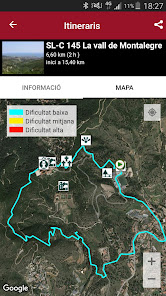
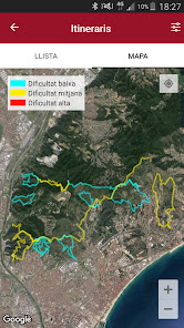
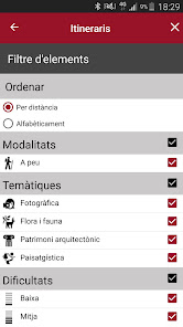
A menu system provides access to information on the itineraries and points of interest of each park, both in map or list format and with an augmented reality viewer. This information is sorted by proximity.
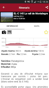
Each itinerary has a complete file that includes the map, the topographic profile, the distance, description, type of itinerary and difficulty; as well as related multimedia items and nearby points of interest. For the latter options, the user must keep the GPS sensor of the mobile phone activated.
The user can create their favorites list and share them via social media, email or WhatsApp.
The signposted itineraries of the Barcelona Provincial Council's Network of Natural Parks are routes planned in the territory, marked with information panels and starting points, which pass through places in natural spaces with relevant elements of the natural, historical and cultural heritage.
A menu system provides access to information on the itineraries and points of interest of each park, both in map or list format and with an augmented reality viewer. This information is sorted by proximity.
Each itinerary has a complete file that includes the map, the topographic profile, the distance, description, type of itinerary and difficulty; as well as related multimedia items and nearby points of interest. For the latter options, the user must keep the GPS sensor of the mobile phone activated.
The user can create their favorites list and share them via social media, email or WhatsApp.
The signposted itineraries of the Barcelona Provincial Council's Network of Natural Parks are routes planned in the territory, marked with information panels and starting points, which pass through places in natural spaces with relevant elements of the natural, historical and cultural heritage.
Updated on
Safety starts with understanding how developers collect and share your data. Data privacy and security practices may vary based on your use, region and age. The developer provided this information and may update it over time.

No data shared with third parties
Learn more about how developers declare sharing

No data collected
Learn more about how developers declare collection

Data is encrypted in transit

Data can’t be deleted
What's new
- Arreglat un problema al filtre per parc
App support
About the developer
Diputació de Barcelona
roselloco@diba.cat
Rambla de Catalunya, 126
08008 Barcelona
Spain
+34 626 35 20 88