
AgroforMap
5K+
Downloads

Everyone
info


About this app
Application features:
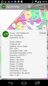
- The data of each field, each planting within reach of a click on the screen;
- Quick consultations on the situation of each plantation: performance, applications, management executed, previous crop, plantation mode, planting date, soil, etc. (Variables are unique to each client);
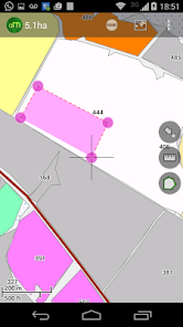
- Function for calculation of areas and measures distances;
- Function "My position" allowing the user to accompany the device location;
- Photos, screenshots, maps multi schemes, recording routes;
- Easy and quick handling of the application allows the user to practical experience;
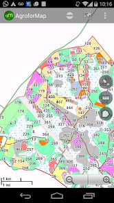
- Enables offline access to all maps and customer database;
- Without the need to have the field maps and spreadsheets, application activities and optimizes operator time;
- Your company with much more speed and agility in agroforestry.
- The data of each field, each planting within reach of a click on the screen;
- Quick consultations on the situation of each plantation: performance, applications, management executed, previous crop, plantation mode, planting date, soil, etc. (Variables are unique to each client);
- Function for calculation of areas and measures distances;
- Function "My position" allowing the user to accompany the device location;
- Photos, screenshots, maps multi schemes, recording routes;
- Easy and quick handling of the application allows the user to practical experience;
- Enables offline access to all maps and customer database;
- Without the need to have the field maps and spreadsheets, application activities and optimizes operator time;
- Your company with much more speed and agility in agroforestry.
Updated on
Safety starts with understanding how developers collect and share your data. Data privacy and security practices may vary based on your use, region and age. The developer provided this information and may update it over time.

No data shared with third parties
Learn more about how developers declare sharing

No data collected
Learn more about how developers declare collection
What's new
Minor bugs fixed
App support
About the developer
Ramiro Baez
ibccartografia@gmail.com
Av. Polonia 1344
N3301 Posadas
Misiones
Argentina