

即時路況影像 (台灣路況即時影像、測速照相偵測以及天氣查詢)
Contains adsIn-app purchases

4.8star
2.77K reviews
100K+
Downloads

Everyone
info


About this app
Real-time Traffic Images - Live Traffic Images, Speed Camera Detection, Police Radio Traffic Information, Basic Weather Information, and Night Market Maps
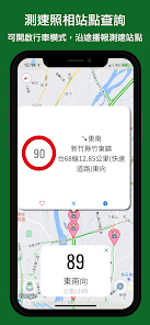
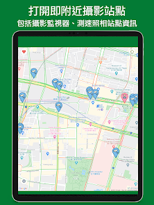
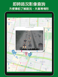
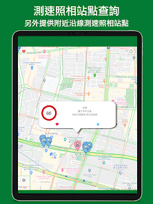
Tap on your location to instantly map nearby cameras, police radio traffic information, and speed camera stations, giving you a quick overview of traffic conditions. The map is zoomable, eliminating the need for a small thumbnail image. You can quickly view traffic conditions, nearby tourist attractions (including a separate night market map), and basic weather information. A speed camera mode is also available, which displays speed camera stations and cameras along the way.
Key Features:
- Open and Run: Tap on your location to instantly map nearby live CCTV images and speed camera station information. The nearest 50 stations are always displayed, and the display dynamically updates based on your location as you move your map.
- Navigation Speed Camera Mode: Navigate to a specific destination and receive navigation information, along with speed camera stations and cameras along the way. You can also use it as a floating window (picture-in-picture) for simultaneous use with other navigation and map apps. - Radio Station Playback: The Speed Camera mode page provides a list of multiple radio stations for simultaneous playback, including the national Police Radio network and local Police Radio stations.
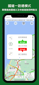
- Highway One-Stop Mode: Incorporating the existing "Highway One-Stop" app, this mode displays real-time highway traffic conditions (including real-time highway traffic conditions) and expressway traffic conditions and images.
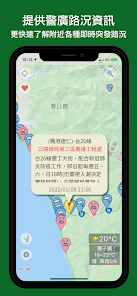
- Police Radio Information: Provides dynamic traffic information for Police Radio stations.
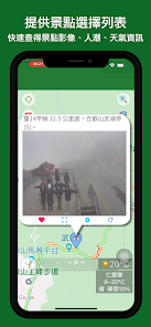
- Tourism Information: Provides information on attractions, events, restaurants, B&Bs, and more from the Tourism Bureau.
- Taiwan Night Market Map: The scenic area now displays the location of nearby night markets, including basic information such as opening days. If there are any omissions or changes, please email us to request revisions. Thank you.
- Place Name Information: Provides geographical information such as streets, settlements, public facilities, and physical geography.
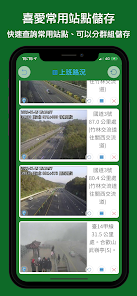
- Section Speed Measurement: In addition to speed camera stations, this mode also provides the option to display section speed measurement data (including technology enforcement, noise, illegal parking, etc.). - Favorite Points: Save frequently visited stops for quick access.
- Comprehensive Data: Includes CCTV cameras for county and city roads, provincial highways, national expressways, and other locations, as well as speed camera locations across Taiwan.
- County and City List: Quickly navigate to a specific county or city to view nearby footage.
- Popular Attractions: Compiles image lists of various attractions provided by various counties and cities.
- Enter Location: Integrates stop name data from the "Next Bus" app to quickly navigate to footage near bus stops.
- Live Weather Forecast: View daily and weekly regional forecasts, receive push notifications for air quality changes, and receive morning and evening weather forecasts.
Other Details:
- Live traffic conditions now support full-screen zooming for live footage.
- Favorite Stops list displays live footage.
Data sources include:
- Traffic surveillance camera data from various counties and cities
- Traffic surveillance camera data from the Highway Bureau of the Ministry of Transportation and Communications
- Traffic surveillance camera data from the Highway Administration of the Ministry of Transportation and Communications
- Speed enforcement point data from the National Police Administration of the Ministry of the Interior
- Real-time traffic information from the National Police Administration of the Ministry of the Interior
- Taiwan place name data from the Bureau of Lands of the Ministry of the Interior
- Tourism Information Database of the Tourism Bureau of the Ministry of Transportation and Communications
- Fixed high-noise vehicle detection camera system data from the Environmental Protection Administration of the Ministry of the Interior
- Climate data from the Central Weather Bureau of the Ministry of Transportation and Communications
Broadcast stations include:
- Police Broadcasting Station (national and local networks): https://www.pbs.npa.gov.tw/
Tap on your location to instantly map nearby cameras, police radio traffic information, and speed camera stations, giving you a quick overview of traffic conditions. The map is zoomable, eliminating the need for a small thumbnail image. You can quickly view traffic conditions, nearby tourist attractions (including a separate night market map), and basic weather information. A speed camera mode is also available, which displays speed camera stations and cameras along the way.
Key Features:
- Open and Run: Tap on your location to instantly map nearby live CCTV images and speed camera station information. The nearest 50 stations are always displayed, and the display dynamically updates based on your location as you move your map.
- Navigation Speed Camera Mode: Navigate to a specific destination and receive navigation information, along with speed camera stations and cameras along the way. You can also use it as a floating window (picture-in-picture) for simultaneous use with other navigation and map apps. - Radio Station Playback: The Speed Camera mode page provides a list of multiple radio stations for simultaneous playback, including the national Police Radio network and local Police Radio stations.
- Highway One-Stop Mode: Incorporating the existing "Highway One-Stop" app, this mode displays real-time highway traffic conditions (including real-time highway traffic conditions) and expressway traffic conditions and images.
- Police Radio Information: Provides dynamic traffic information for Police Radio stations.
- Tourism Information: Provides information on attractions, events, restaurants, B&Bs, and more from the Tourism Bureau.
- Taiwan Night Market Map: The scenic area now displays the location of nearby night markets, including basic information such as opening days. If there are any omissions or changes, please email us to request revisions. Thank you.
- Place Name Information: Provides geographical information such as streets, settlements, public facilities, and physical geography.
- Section Speed Measurement: In addition to speed camera stations, this mode also provides the option to display section speed measurement data (including technology enforcement, noise, illegal parking, etc.). - Favorite Points: Save frequently visited stops for quick access.
- Comprehensive Data: Includes CCTV cameras for county and city roads, provincial highways, national expressways, and other locations, as well as speed camera locations across Taiwan.
- County and City List: Quickly navigate to a specific county or city to view nearby footage.
- Popular Attractions: Compiles image lists of various attractions provided by various counties and cities.
- Enter Location: Integrates stop name data from the "Next Bus" app to quickly navigate to footage near bus stops.
- Live Weather Forecast: View daily and weekly regional forecasts, receive push notifications for air quality changes, and receive morning and evening weather forecasts.
Other Details:
- Live traffic conditions now support full-screen zooming for live footage.
- Favorite Stops list displays live footage.
Data sources include:
- Traffic surveillance camera data from various counties and cities
- Traffic surveillance camera data from the Highway Bureau of the Ministry of Transportation and Communications
- Traffic surveillance camera data from the Highway Administration of the Ministry of Transportation and Communications
- Speed enforcement point data from the National Police Administration of the Ministry of the Interior
- Real-time traffic information from the National Police Administration of the Ministry of the Interior
- Taiwan place name data from the Bureau of Lands of the Ministry of the Interior
- Tourism Information Database of the Tourism Bureau of the Ministry of Transportation and Communications
- Fixed high-noise vehicle detection camera system data from the Environmental Protection Administration of the Ministry of the Interior
- Climate data from the Central Weather Bureau of the Ministry of Transportation and Communications
Broadcast stations include:
- Police Broadcasting Station (national and local networks): https://www.pbs.npa.gov.tw/
Updated on
Safety starts with understanding how developers collect and share your data. Data privacy and security practices may vary based on your use, region and age. The developer provided this information and may update it over time.

No data shared with third parties
Learn more about how developers declare sharing

This app may collect these data types
Location, App activity and 2 others

Data is encrypted in transit

Data can’t be deleted
What's new
1. 改善影像沒有立即載入的問題
2. 改善加油站圖標點沒固定的問題
2. 改善加油站圖標點沒固定的問題
App support
About the developer
獨巍資訊應用有限公司
feedback@doitwell.app
三民路111號4樓之3
芎林鄉
新竹縣, Taiwan 307604
+886 916 291 640


