Pegelstände Niedersachsen
10K+
Downloads

Everyone
info
About this app
Note: the high water level of the state of Lower Saxony, for which responsibility lies with the NLWKN and a variety of levels of the Federal Waterways Administration, located in Lower Saxony are shown exclusively (see also http://www.pegelonline.nlwkn.niedersachsen.de). Level data from other states are not displayed.
Have you ever been affected by flooding or even flood?
You can now use the official app of the water levels NLWKN (Lower Saxony State Office for Water Management, Coastal and Conservation) on the road and information at home about the current level of Lower Saxony waters.
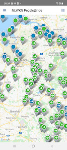
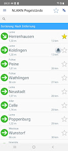
Find monitoring stations on rivers near you with the integrated environment looking and innovative card list, add them to favorites and maintain at all times an overview.
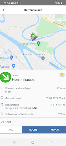
The trend calculation and display of the current reporting levels help you in time to induce action if your belongings was endangered by rising waters.
The loving design and ease of use make this app the number one reference in water levels apps.
features:
● Current water levels in Lower Saxony Rivers
● push notifications
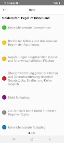
● trend calculations (for example, the level has increased or decreased?)
● Managing favorites
● Proximity search
● overview map with integrated trend and alarm level display
● detailed daily, weekly, monthly overview of the level curve in a clear graphic
Do you have questions or suggestions regarding the NLWKN Pegelapp?
Contact us at: pressestelle@nlwkn-dir.niedersachsen.de
Please note:
When opening the application (also from the background) must have an Internet connection so that the current data can be loaded.
The timeliness of the data depends on the database of the NLWKN, there can therefore be no guarantee that the data is complete and correct.
Have you ever been affected by flooding or even flood?
You can now use the official app of the water levels NLWKN (Lower Saxony State Office for Water Management, Coastal and Conservation) on the road and information at home about the current level of Lower Saxony waters.
Find monitoring stations on rivers near you with the integrated environment looking and innovative card list, add them to favorites and maintain at all times an overview.
The trend calculation and display of the current reporting levels help you in time to induce action if your belongings was endangered by rising waters.
The loving design and ease of use make this app the number one reference in water levels apps.
features:
● Current water levels in Lower Saxony Rivers
● push notifications
● trend calculations (for example, the level has increased or decreased?)
● Managing favorites
● Proximity search
● overview map with integrated trend and alarm level display
● detailed daily, weekly, monthly overview of the level curve in a clear graphic
Do you have questions or suggestions regarding the NLWKN Pegelapp?
Contact us at: pressestelle@nlwkn-dir.niedersachsen.de
Please note:
When opening the application (also from the background) must have an Internet connection so that the current data can be loaded.
The timeliness of the data depends on the database of the NLWKN, there can therefore be no guarantee that the data is complete and correct.
Updated on
Safety starts with understanding how developers collect and share your data. Data privacy and security practices may vary based on your use, region and age The developer provided this information and may update it over time.

No data shared with third parties
Learn more about how developers declare sharing

This app may collect these data types
Device or other IDs

Data isn’t encrypted
Data can’t be deleted
What's new
Refactoring des Systemcodes