
iSentieri Gran San Bernardo
1K+
Downloads

Everyone
info


About this app
The APP was designed to make access to the main trails of the Gran San Bernardo valley more accessible.
The itineraries are searchable by:
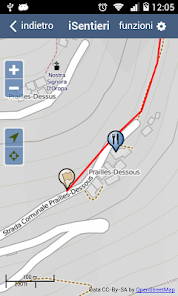
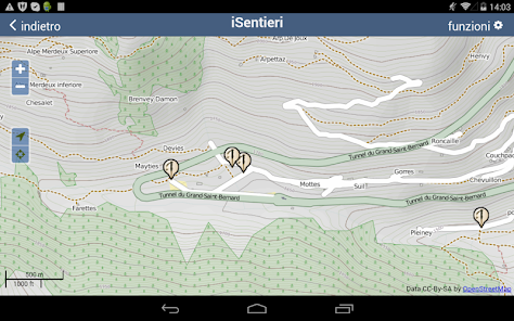
- map
- name of the itinerary
For each itinerary it is possible to view:
- a description of how to access the starting point from Aosta or coming from the Gran San Bernardo tunnel
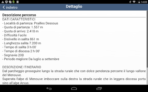
- a general description of the route with the main features
- all technical data (departure and altitude, arrival and altitude, difficulty, difference in height, length, time of ascent and descent, best period) and a detailed description of the ascent route.
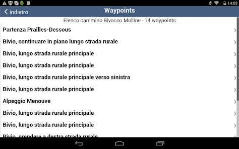
- WPs that can be points of attention (crossroads) or of interest (landscape or cultural interest, etc.). For the points of attention there will be a brief description, for the points of interest the description will be more detailed.
The basic cartography used is the one made available by OpenStreetMap which contains, in addition to the basic indications, also contour lines and paths.
Specific features of the APP:
- Help, using the maps available on Google Maps, to arrive at the starting point of the excursion.
- Acoustic signaling when approaching a W.P. (only if track recording is enabled)
- Acoustic signal when leaving the correct itinerary. (functionality present only if track recording is activated)
- View the altitude and WGS84 cartographic coordinates you are on
- Dynamic technical data to arrive at the end of the itinerary
- Possibility to record the track and then send it by email
Keep in mind that the use of GPS has a considerable energy absorption and tends to make the cell phone download quickly (two - five hours).
To solve this problem it is advisable to have an additional battery.
Alternatively the APP allows you to suspend the GPS, in this way the battery life increases considerably.
They are also visible:
- The images of the single itinerary
- A list of links to websites of interest
Points of interest:
The main points of interest are inserted: where to sleep, where to eat, heritage and services.
The main information is provided for each point of interest.
Considering that some areas do not have telephone coverage, it is advisable to preload the basic mapping locally from the configuration.
In any case it is always essential to have a map to use if there were problems with the APP or there were problems with the battery. (always recommend the spare battery).
The itineraries are searchable by:
- map
- name of the itinerary
For each itinerary it is possible to view:
- a description of how to access the starting point from Aosta or coming from the Gran San Bernardo tunnel
- a general description of the route with the main features
- all technical data (departure and altitude, arrival and altitude, difficulty, difference in height, length, time of ascent and descent, best period) and a detailed description of the ascent route.
- WPs that can be points of attention (crossroads) or of interest (landscape or cultural interest, etc.). For the points of attention there will be a brief description, for the points of interest the description will be more detailed.
The basic cartography used is the one made available by OpenStreetMap which contains, in addition to the basic indications, also contour lines and paths.
Specific features of the APP:
- Help, using the maps available on Google Maps, to arrive at the starting point of the excursion.
- Acoustic signaling when approaching a W.P. (only if track recording is enabled)
- Acoustic signal when leaving the correct itinerary. (functionality present only if track recording is activated)
- View the altitude and WGS84 cartographic coordinates you are on
- Dynamic technical data to arrive at the end of the itinerary
- Possibility to record the track and then send it by email
Keep in mind that the use of GPS has a considerable energy absorption and tends to make the cell phone download quickly (two - five hours).
To solve this problem it is advisable to have an additional battery.
Alternatively the APP allows you to suspend the GPS, in this way the battery life increases considerably.
They are also visible:
- The images of the single itinerary
- A list of links to websites of interest
Points of interest:
The main points of interest are inserted: where to sleep, where to eat, heritage and services.
The main information is provided for each point of interest.
Considering that some areas do not have telephone coverage, it is advisable to preload the basic mapping locally from the configuration.
In any case it is always essential to have a map to use if there were problems with the APP or there were problems with the battery. (always recommend the spare battery).
Updated on
Safety starts with understanding how developers collect and share your data. Data privacy and security practices may vary based on your use, region and age. The developer provided this information and may update it over time.

No data shared with third parties
Learn more about how developers declare sharing

This app may collect these data types
Location, Personal info and Photos and videos

Data is encrypted in transit

You can request that data be deleted
App support
About the developer
SAEC SRL
info@saec.net
STRADA CONOZ 10
11024 CHATILLON
Italy
+39 349 592 4952


