GNSS Status (GPS Test)
Contains adsIn-app purchases
4.6star
1.26K reviews
500K+
Downloads

Everyone
info


About this app
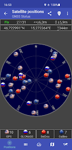
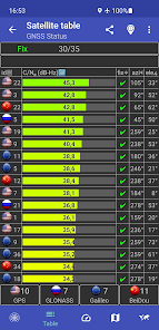
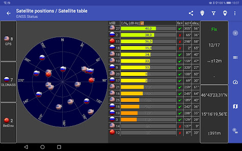
This app is a tool for displaying the GPS status and the status of other GNSS (global navigation satellite systems). It provides all information about all GNSS supported by your device (GPS, GLONASS, Galileo, BeiDou, ...).
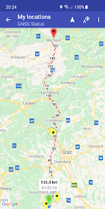
Your location can be shown as latitude/longitude, UTM (Universal Transverse Mercator), MGRS (Military Grid Reference System), OLC (Open Location Code / Plus Code), Mercator, QTH/Maidenhead, Geohash or CH1903+.
Via the "Share" functionality you can share your location to tell someone exactly where you are, this can be very helpful not only in emergencies. Location can be shared as latitude/longitude or as link to all major map services.
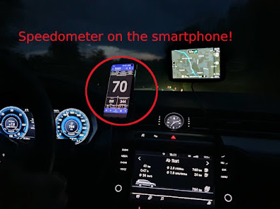
Furthermore, functions such as a GPS speedometer, a "Find my car" and a "My Places" functionality are integrated. This makes it possible to calculate and display routes to the location of the car or to other previously saved locations and to be able to navigate there.
The app supports the display of any GPX files with various map services.
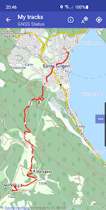
New: Record your tracks while hiking, running or cycling, or import GPX files to find the right path while hiking, running or cycling. Export your captured tracks as GPX files. While hiking, running or cycling, you can share your previous route and your current location as a GPX file via email or social networks at any time. The finished GPX file can also be shared via email and social networks. At the recipient of the shared GPX file, clicking on this file opens and displays our app.
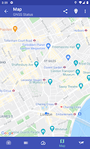
Choose between several map providers for the map displays, we also support offline maps!
Your location can be shown as latitude/longitude, UTM (Universal Transverse Mercator), MGRS (Military Grid Reference System), OLC (Open Location Code / Plus Code), Mercator, QTH/Maidenhead, Geohash or CH1903+.
Via the "Share" functionality you can share your location to tell someone exactly where you are, this can be very helpful not only in emergencies. Location can be shared as latitude/longitude or as link to all major map services.
Furthermore, functions such as a GPS speedometer, a "Find my car" and a "My Places" functionality are integrated. This makes it possible to calculate and display routes to the location of the car or to other previously saved locations and to be able to navigate there.
The app supports the display of any GPX files with various map services.
New: Record your tracks while hiking, running or cycling, or import GPX files to find the right path while hiking, running or cycling. Export your captured tracks as GPX files. While hiking, running or cycling, you can share your previous route and your current location as a GPX file via email or social networks at any time. The finished GPX file can also be shared via email and social networks. At the recipient of the shared GPX file, clicking on this file opens and displays our app.
Choose between several map providers for the map displays, we also support offline maps!
Updated on
Safety starts with understanding how developers collect and share your data. Data privacy and security practices may vary based on your use, region, and age. The developer provided this information and may update it over time.


Ratings and reviews
4.6
1.22K reviews

yashar
- Flag inappropriate
October 6, 2025
Very useful but devs need to improve UI UX

Daniel Hermes
- Flag inappropriate
November 24, 2020
I love this app! It shows a map of all visible satellites and from which country/system they are. It's also possible to filter for constellations, i.e. to show only Galileo and GPS satellites. There's also a bunch of useful information like accuracy, number of satellites in sight and how many of those are used for location fix and signal to noise density (C/N0), azimuthal and elevation angle for each satellite. I didn't even know we can see the 🇯🇵 QZSS system here in 🇩🇪, this app showed me!
279 people found this review helpful

Mayur Savaliya
- Flag inappropriate
October 27, 2025
It fails to detect NavIC
2 people found this review helpful
What’s new
★ Taking altitude into account for calculation of calorie burn
★ Minor enhancements
🐜 Minor fixes
★ Minor enhancements
🐜 Minor fixes
App support
About the developer
Harnisch Gesellschaft m.b.H.
android@harnisch.at
Seltenriegelweg 2
8551 Pölfing-Brunn
Austria
+43 3465 2631


