
GPS Speed And Graph
Contains ads
1K+
Downloads

Everyone
info


About this app
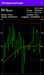
It is an application that measures speed, altitude and coordinates using GPS location information and displays speed and altitude in a graph.
It can output the history of speed and location information to a CSV file.
Displayed content:
-Current speed
-Maximum speed
-Average speed
-Advanced
-Travel distance
-Current Position Coordinates
Graphing targets:
-Current speed
-Maximum speed
-Average speed
-Advanced
The units of speed, distance and altitude can be changed.
Note:
Depending on the GPS status, it may take some time for the measurement to start.
The minimum update interval of the display is 2 seconds, but it may be longer depending on the GPS status.
The CSV output is metric only, and the maximum size is 10 MB per file.
There is no ability to view the contents of a CSV file.
Battery consumption will be higher due to the use of the device's GPS function.
Updated on
Safety starts with understanding how developers collect and share your data. Data privacy and security practices may vary based on your use, region, and age. The developer provided this information and may update it over time.


What’s new
fine tuning
App support
About the developer
花峯俊和
hana87.soft@gmail.com
Japan
undefined