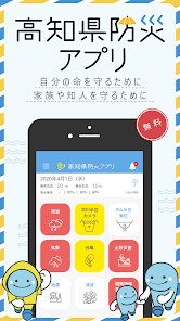
高知県防災アプリ
10K+
Downloads

Everyone
info

About this app
"Kochi Prefecture Disaster Prevention App" is developed and operated by Kochi Prefecture.
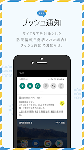
Information required for evacuation decisions, such as weather information, evacuation information, river water levels and the risk of landslide disasters, is automatically notified by push notification.
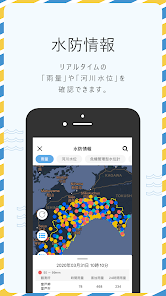
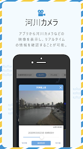
In addition, with the camera function, you can check changes in river water levels from 24 hours ago to the present.
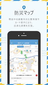
Furthermore, with the disaster prevention map function, you can check the location and hazard map of the established evacuation centers, and also check the routes to the evacuation centers.
In addition, if you register your family and neighbors with the group function, you can also inform your safety and send out SOS.
There is also a function that can be switched to three modes of "general mode", "junior (child) mode" and "senior (elderly) mode" according to each age so that it can be used widely from children to elderly people. I am.
"Main features"
・ Push notification of disaster prevention and national protection information
・ Indication of rainfall information, river and road cameras, etc.
・ Display of disaster prevention maps (evacuation sites, evacuation sites, hazard maps)
・ Group registration, safety confirmation
・ Disaster prevention learning ・ Disaster prevention quiz
・ Mode switching (general mode, junior (child) mode, senior (elderly) mode)
Information required for evacuation decisions, such as weather information, evacuation information, river water levels and the risk of landslide disasters, is automatically notified by push notification.
In addition, with the camera function, you can check changes in river water levels from 24 hours ago to the present.
Furthermore, with the disaster prevention map function, you can check the location and hazard map of the established evacuation centers, and also check the routes to the evacuation centers.
In addition, if you register your family and neighbors with the group function, you can also inform your safety and send out SOS.
There is also a function that can be switched to three modes of "general mode", "junior (child) mode" and "senior (elderly) mode" according to each age so that it can be used widely from children to elderly people. I am.
"Main features"
・ Push notification of disaster prevention and national protection information
・ Indication of rainfall information, river and road cameras, etc.
・ Display of disaster prevention maps (evacuation sites, evacuation sites, hazard maps)
・ Group registration, safety confirmation
・ Disaster prevention learning ・ Disaster prevention quiz
・ Mode switching (general mode, junior (child) mode, senior (elderly) mode)
Updated on
Safety starts with understanding how developers collect and share your data. Data privacy and security practices may vary based on your use, region, and age. The developer provided this information and may update it over time.

No data shared with third parties
Learn more about how developers declare sharing

No data collected
Learn more about how developers declare collection
What's new
・防災マップに津波災害警戒区域を追加しました。
・一部のプッシュ通知の受信エリアについて、旧市町村で設定できるようになりました。
・熱中症警戒アラートの通知を追加しました。
・その他軽微な修正を行いました。
・一部のプッシュ通知の受信エリアについて、旧市町村で設定できるようになりました。
・熱中症警戒アラートの通知を追加しました。
・その他軽微な修正を行いました。
App support
phone
Phone number
+81357771033