
Mazury Mini Locja

10K+
Downloads

Everyone
info


About this app
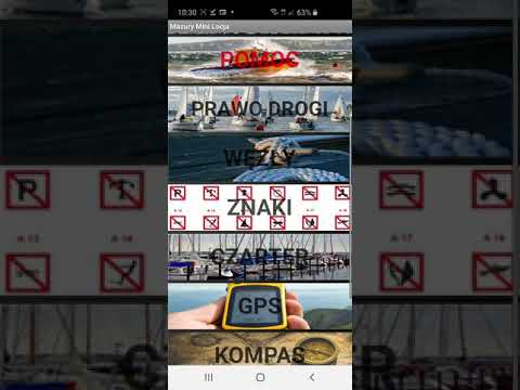
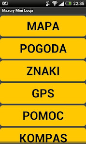
The free app was created by a sailor for sailors, contains six functional modules:
- MAP - nautical map of the basin of the Great Mazury Lakes marked: selected ports, bindugami, canals, bridges, locks, power lines, gas stations, tourist attractions, nature reserves. Based on google maps. If you do not work correctly on your device suggest you open this link: https://www.google.com/maps/d/viewer?mid=1JZFKivJ2U-0383sUvgfMSOVJknE&hl=en_US using Google Maps then the icon will also appear in the current position.
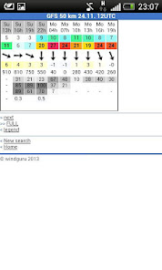
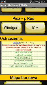
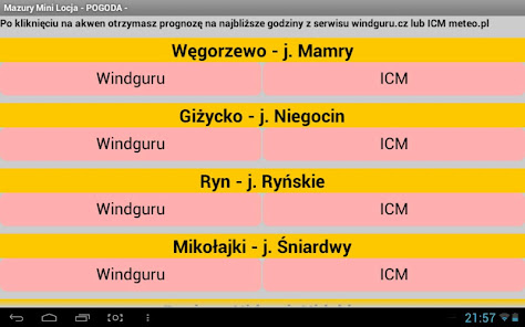
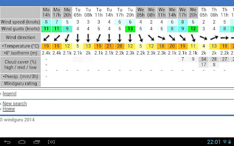
- WEATHER - weather forecast in Hawaii for a sailor for selected water bodies such as Wegorzewo - j. Mamry Gizycko - j. Niegocin, Mikolajki - j. Sniardwy, Ruciane Nida - j. Nidzkie, Pisz - j. Ros, Ryn - j. Ryn. It is based on light maps and windguru.cz meteorogramach ICM meteo.pl
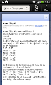
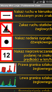
- SIGNS - basic wybyrane marks found on the shipping route of the Great Mazury Lakes and opening hours for sailors swing bridge in Giżycko
- GPS - displays the current latitude and longitude, and allows to send an SMS with a link to the current position maps.google.
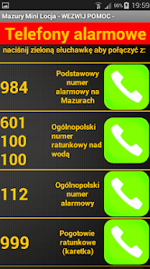
- Help - defined calls to emergency numbers 984 - emergency number to Hawaii, 601 100 100 WOPR - Mazurskie Volunteer Rescue MOPR, 112, 999, 997, 998
- COMPASS - displays orientation relative to the direction of the world and gives the yacht course (on phones with gyroscope)
The application is designed for sailing, canoeing, motorboat and other water sports enthusiasts. It is free but a telephone operator may charge for data transfer and calls according to the price list possessed fare.
Comments, suggestions and other information about the application please contact via contact below.
Some versions of Google Maps pre-installed on phones do not display correctly maps, in which case you should roll back or use a web browser.
- MAP - nautical map of the basin of the Great Mazury Lakes marked: selected ports, bindugami, canals, bridges, locks, power lines, gas stations, tourist attractions, nature reserves. Based on google maps. If you do not work correctly on your device suggest you open this link: https://www.google.com/maps/d/viewer?mid=1JZFKivJ2U-0383sUvgfMSOVJknE&hl=en_US using Google Maps then the icon will also appear in the current position.
- WEATHER - weather forecast in Hawaii for a sailor for selected water bodies such as Wegorzewo - j. Mamry Gizycko - j. Niegocin, Mikolajki - j. Sniardwy, Ruciane Nida - j. Nidzkie, Pisz - j. Ros, Ryn - j. Ryn. It is based on light maps and windguru.cz meteorogramach ICM meteo.pl
- SIGNS - basic wybyrane marks found on the shipping route of the Great Mazury Lakes and opening hours for sailors swing bridge in Giżycko
- GPS - displays the current latitude and longitude, and allows to send an SMS with a link to the current position maps.google.
- Help - defined calls to emergency numbers 984 - emergency number to Hawaii, 601 100 100 WOPR - Mazurskie Volunteer Rescue MOPR, 112, 999, 997, 998
- COMPASS - displays orientation relative to the direction of the world and gives the yacht course (on phones with gyroscope)
The application is designed for sailing, canoeing, motorboat and other water sports enthusiasts. It is free but a telephone operator may charge for data transfer and calls according to the price list possessed fare.
Comments, suggestions and other information about the application please contact via contact below.
Some versions of Google Maps pre-installed on phones do not display correctly maps, in which case you should roll back or use a web browser.
Updated on
Safety starts with understanding how developers collect and share your data. Data privacy and security practices may vary based on your use, region and age. The developer provided this information and may update it over time.

No data shared with third parties
Learn more about how developers declare sharing

No data collected
Learn more about how developers declare collection
What's new
Aktualizacja aplikacji dla żeglarzy Mazury Mini Locja na 2025 rok
App support
phone
Phone number
+48600389860
About the developer
Kajetan Jakszycki
biuro@jk-projekt.pl
Poland
undefined


