

FPL BR - EFB

1K+
Downloads

Everyone
info

About this app
The Aeronautics Command and DECEA provide the FPL BR - EFB application as a means to consult aeronautical publications whenever necessary, even without internet connectivity, in addition to providing georeferenced information and carrying out flight planning.
The main features are:
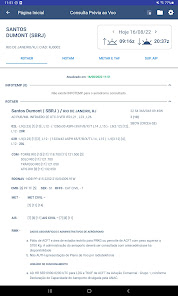
- Consultation of information prior to the flight: ROTAER aerodromes (with infotemp), NOTAM, METAR/TAF and information about Sunrise and Sunset.
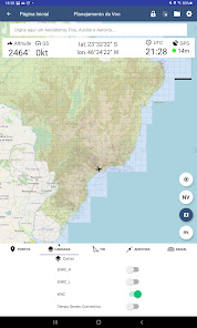
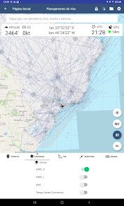
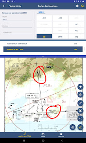
- Consultation of aeronautical charts - aerodromes/TMA, WACs and route (optionally, other types of visual charts can be consulted);
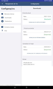
- Validation control of publications based on the AIRAC cycle.
- Consultation of AIP Brasil, AIP MAP documents and AIP Supplements (with annexes);
- Map with Georeferenced information;
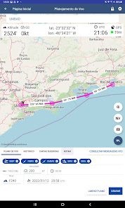
- Possibility of carrying out a flight planning;
- Navigation assistance;
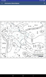
- SIGWX weather charts and SIGMET messages;
- Integration with FPLBR - Flight plan to create a flight plan from a planning;
- Sharing and annotations in aeronautical charts;
- Possibility to create mathematical formulas.
Note: to consult the publications it is necessary to download the cards when starting the application.
The main features are:
- Consultation of information prior to the flight: ROTAER aerodromes (with infotemp), NOTAM, METAR/TAF and information about Sunrise and Sunset.
- Consultation of aeronautical charts - aerodromes/TMA, WACs and route (optionally, other types of visual charts can be consulted);
- Validation control of publications based on the AIRAC cycle.
- Consultation of AIP Brasil, AIP MAP documents and AIP Supplements (with annexes);
- Map with Georeferenced information;
- Possibility of carrying out a flight planning;
- Navigation assistance;
- SIGWX weather charts and SIGMET messages;
- Integration with FPLBR - Flight plan to create a flight plan from a planning;
- Sharing and annotations in aeronautical charts;
- Possibility to create mathematical formulas.
Note: to consult the publications it is necessary to download the cards when starting the application.
Updated on
Safety starts with understanding how developers collect and share your data. Data privacy and security practices may vary based on your use, region and age The developer provided this information and may update it over time.

No data shared with third parties
Learn more about how developers declare sharing

No data collected
Learn more about how developers declare collection
What's new
Melhorias e correções de erros.


