
Wattpaddler
5K+
Downloads

Everyone
info
About this app
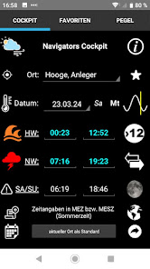
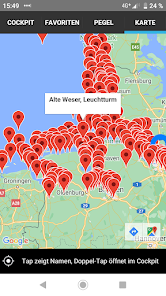
Display of tides for all German reference and connection locations as well as Dutch and Danish tide locations.
Official(!) German, Dutch and Danish tides are displayed for the current year and from autumn also for the coming year.
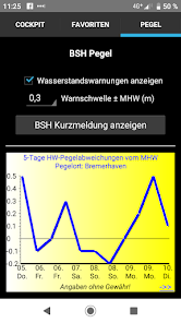
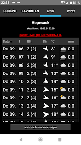
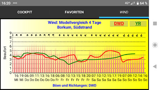
For Germany, integration of the 5-day water level forecast from the BSH, the DWD coastal sea weather report as well as official storm and strong wind warnings for the selected region. Locally accurate weather forecasts from the DWD and Yr.no. Warning of medium (orange wave) and high (red wave) swells. Nautical warning messages from the BSH are also integrated; the app notifies you of a new message.
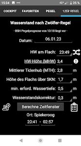
In addition, sea kayakers and sailors with mudflat paddlers can calculate time windows for the passage of a flax in the German Wadden Sea according to the “rule of twelfths”. Spring and neap tides as well as the water level forecasts for the next 5 days are taken into account. Visualization of the current water level using a sine curve. A default location can be saved for immediate viewing. For night trips, the length of civil and nautical twilight, the current moon phase as well as moonrise and sunset times are displayed.
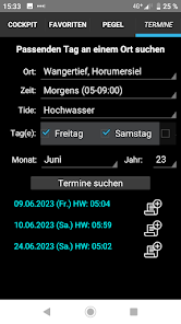
Days that correspond to certain tidal conditions can be specifically searched for, for example: “Evening flood on a Sunday in June”. Underlined words link to additional functions that are activated by tap. Change history see website wattpaddler.de.
Official(!) German, Dutch and Danish tides are displayed for the current year and from autumn also for the coming year.
For Germany, integration of the 5-day water level forecast from the BSH, the DWD coastal sea weather report as well as official storm and strong wind warnings for the selected region. Locally accurate weather forecasts from the DWD and Yr.no. Warning of medium (orange wave) and high (red wave) swells. Nautical warning messages from the BSH are also integrated; the app notifies you of a new message.
In addition, sea kayakers and sailors with mudflat paddlers can calculate time windows for the passage of a flax in the German Wadden Sea according to the “rule of twelfths”. Spring and neap tides as well as the water level forecasts for the next 5 days are taken into account. Visualization of the current water level using a sine curve. A default location can be saved for immediate viewing. For night trips, the length of civil and nautical twilight, the current moon phase as well as moonrise and sunset times are displayed.
Days that correspond to certain tidal conditions can be specifically searched for, for example: “Evening flood on a Sunday in June”. Underlined words link to additional functions that are activated by tap. Change history see website wattpaddler.de.
Updated on
Safety starts with understanding how developers collect and share your data. Data privacy and security practices may vary based on your use, region and age The developer provided this information and may update it over time.

No data shared with third parties
Learn more about how developers declare sharing

No data collected
Learn more about how developers declare collection
What's new
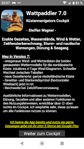
- ortsgenaue Wind- und Wetterdaten der beiden genauesten Wettermodelle für die norddeutsche Küste. Intuitives 4-Tage Wind-Diagramm. Schneller Wechsel zwischen Tabellen
- neue Gezeitenorte: ganze niederländische Küste
- Gewitter- und Starkwindsymbol (horizontaler Windsack) jetzt in rot
- Reichweite bei Zeitdifferenzmessung
- neue Gezeitenorte: ganze niederländische Küste
- Gewitter- und Starkwindsymbol (horizontaler Windsack) jetzt in rot
- Reichweite bei Zeitdifferenzmessung