
アルパカナビ | 登山のコースナビ・GPS
In-app purchases
5K+
Downloads

Everyone
info

About this app
Or master so far is climbing for GPS app to study a lot of function, it was only one without map and the great difference of paper simple too. There was no "just right" app.
And easy to use, safe us safely to navigation. It was made as such application is the "alpaca Navi". "ALPACA NAVI" is an abbreviation of "Alpine auto calculable Navigator". It leads to the destination of the climbers in all automatic.
※ alpaca Navi is a newborn toddler. Please watch gently for a while. Function improvement, course additions, bug fixes will be performed at any time.
※ development of the course data is sorry has been delayed. Please wait a little because we are made little by little. The course of the request, up to here on the specified climbing route. keiziweb@gmail.com
※ This app contains the source code of the Apache Software License 2.0 license.
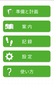
■ Easy to use
1. To install the app.
2. Start tap the "planning and preparation" Once you have.
3. Region, mountain, choose the course download you want to climb.
4. After downloading the course, it will start the download of as it is necessary map.
5. Let's go to the mountain climbing When you are ready. Guide will start by tapping the "guidance" of the menu.
6. Stop guide also automatically be put on goal. Walked record is located in the "recording" of the menu.
7. Record can be sent by e-mail and file-sharing application.
Easy operation, for us to just the right feeling smartphone is guide.
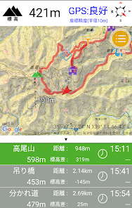
■ navigation function
· GPS is also available in mobile phone out of range of the mountains. It is obvious you are in everywhere in the mountains.
· Aim distance to the point, the altitude difference, will tell the time in the voice.
- to warn in a voice Once you deviate from the course.
- You can also create a course on your own. The course file created can be shared with colleagues.
■ History
Alpaca navigation headwaters the iPhone version, which was published in 2010 "DIY GPS". It was born from there is the "geo-graphical" iPhone and Android support both. Simply summarizes the features of geo-graphical, alpaca Navi was born as an application to link automatically the necessary functions.
We designed anyone as use the advanced features easy.
New but there is a history, it is the alpaca Navi.
■ compatible models
Equipped with smartphone AndroidOS4.0 more. GPS, acceleration sensor, is equipped with electronic compass is required.
It is not possible to ensure the normal operation of the device in all of the Android devices. By the difference between the models, may not fully operational. First and check the operation, please purchase the "function restriction release" in-app purchase if you like.
Old models, such as 2012 earlier released is not good so much performance. We do not know only bad position information of the accuracy of the GPS accuracy is poor terminal. If possible, please use a newer model (2014 model year or later). Because Android devices are differences GPS accuracy depending on the model, please choose the high precision models examine reviews and the like. That's GPS accuracy is poor models, also I get is an error in the position to be displayed on the course application.
■ In-app Billing
Installation and trial is free, but there is a limit to some function.
Or restrict content
The number of downloads of course is up to 20 lines.
Export of track requires a function restriction release.
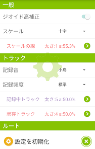
To use the backup function in the configuration screen is required function restriction release.
There is no other restriction. Order from in-app billing from the function restriction release of the setting, the limit will be canceled. If you liked alpaca navigation, thank you the billing.
■ Frequently Asked Questions and Answers
Q. I want to use because the course Toka good like freely GoogleMap.
A. The kind of usage will not match the "geo-graphical". Please use the geo-graphical.
Q. You are here does not appear.
A. GPS is and is disabled can not positioning of the current position. Please turn on the high precision in the "location services" of the terminal set. In addition, the error will occur in position information order can not be positioning by GPS satellites indoors or underground. Please use outdoors.
Q. Speech function is speak English, or not talk.
A. Perhaps "Language and input → text-to-speech output" of the terminal setting is English. Please choose the voice engine of the Japanese. Or, please install the N2TTS in GooglePlay. You can choose your favorite voice from various Japanese voice engine.
https://play.google.com/store/apps/details?id=jp.kddilabs.n2tts&hl=ja
■ Disclaimer and Precautions
Alpaca Navigation (below those apps) developers for damages caused by using does not assume any responsibility.
• If the waterproof and dustproof cold performance is low models, please pay attention to the water wet and cold If you want to use in climbing. Please be warm in a pocket if the power is lost in the cold. Please start the alpaca navigation Once the power is turned on. Resumes operation.
Installation of this app is free, it has become a method to unlock some features limited in-app billing. Be sure to try at your own terminal, please purchase on the consent to function. We can not respond to the refund after the purchase.
- forever it does not guarantee the operation in all of AndroidOS. In the future, it is possible that no longer work in the change of model and OS (can not do permanent support).
The accuracy of and information provided by this application program, reliability, developers in the utility does not take any responsibility. It will be if you use at your own risk.
And use of while walking is dangerous. Please use stopped in a safe place.
- such as GPS log and route guidance, if you use the GPS in the background operations will consume the battery. Do you have a sure mobile battery and charger cable If you want to use in the outdoors.
· Preparation for unforeseen circumstances, let's go to the mountain with a paper map and compass.
Of app usage has been written in the built-in help. You can see a description of each function from "Using" in the menu screen.
- monthly fee does not occur. App purchase "function restriction release" is OK if it is possible to purchase once.
• This app uses the Geographical Survey Institute and Web services of OpenStreetmap, such as Google's MapSDK. Operation status of each Web service, due to specification changes, please note that this application program and there is a situation that can not be used (if possible correspond).
And questions about the application, for the bug report, please send e-mail or facebook page. [Menu] in the app - You can send from the inquiry mail] - [how to use].
facebook page: https: //www.facebook.com/alpacanavi/
※ career-mail (@ such as docomo.ne.jp and @ ezweb.ne.jp) us to send an e-mail with, here is some people can not reply with an error When you reply. Please use the career non-mail address (@ gmail.com, etc.) if possible.
■ About crash report
Android has a mechanism to send the report to the developers app crashes. And who can write about the situation and the operation was carried out of the previous generation to user comments, so thank you for your cooperation becomes a clue of modification.
■ license information, etc.
Map data is using the Geographical Survey Institute, Open Street Map, a Google's Web services.
· Apache uses the CWAC TouchListView of Software License 2.0 license.
• Some UI design was going to the anime Sword Art Online as a reference.
And easy to use, safe us safely to navigation. It was made as such application is the "alpaca Navi". "ALPACA NAVI" is an abbreviation of "Alpine auto calculable Navigator". It leads to the destination of the climbers in all automatic.
※ alpaca Navi is a newborn toddler. Please watch gently for a while. Function improvement, course additions, bug fixes will be performed at any time.
※ development of the course data is sorry has been delayed. Please wait a little because we are made little by little. The course of the request, up to here on the specified climbing route. keiziweb@gmail.com
※ This app contains the source code of the Apache Software License 2.0 license.
■ Easy to use
1. To install the app.
2. Start tap the "planning and preparation" Once you have.
3. Region, mountain, choose the course download you want to climb.
4. After downloading the course, it will start the download of as it is necessary map.
5. Let's go to the mountain climbing When you are ready. Guide will start by tapping the "guidance" of the menu.
6. Stop guide also automatically be put on goal. Walked record is located in the "recording" of the menu.
7. Record can be sent by e-mail and file-sharing application.
Easy operation, for us to just the right feeling smartphone is guide.
■ navigation function
· GPS is also available in mobile phone out of range of the mountains. It is obvious you are in everywhere in the mountains.
· Aim distance to the point, the altitude difference, will tell the time in the voice.
- to warn in a voice Once you deviate from the course.
- You can also create a course on your own. The course file created can be shared with colleagues.
■ History
Alpaca navigation headwaters the iPhone version, which was published in 2010 "DIY GPS". It was born from there is the "geo-graphical" iPhone and Android support both. Simply summarizes the features of geo-graphical, alpaca Navi was born as an application to link automatically the necessary functions.
We designed anyone as use the advanced features easy.
New but there is a history, it is the alpaca Navi.
■ compatible models
Equipped with smartphone AndroidOS4.0 more. GPS, acceleration sensor, is equipped with electronic compass is required.
It is not possible to ensure the normal operation of the device in all of the Android devices. By the difference between the models, may not fully operational. First and check the operation, please purchase the "function restriction release" in-app purchase if you like.
Old models, such as 2012 earlier released is not good so much performance. We do not know only bad position information of the accuracy of the GPS accuracy is poor terminal. If possible, please use a newer model (2014 model year or later). Because Android devices are differences GPS accuracy depending on the model, please choose the high precision models examine reviews and the like. That's GPS accuracy is poor models, also I get is an error in the position to be displayed on the course application.
■ In-app Billing
Installation and trial is free, but there is a limit to some function.
Or restrict content
The number of downloads of course is up to 20 lines.
Export of track requires a function restriction release.
To use the backup function in the configuration screen is required function restriction release.
There is no other restriction. Order from in-app billing from the function restriction release of the setting, the limit will be canceled. If you liked alpaca navigation, thank you the billing.
■ Frequently Asked Questions and Answers
Q. I want to use because the course Toka good like freely GoogleMap.
A. The kind of usage will not match the "geo-graphical". Please use the geo-graphical.
Q. You are here does not appear.
A. GPS is and is disabled can not positioning of the current position. Please turn on the high precision in the "location services" of the terminal set. In addition, the error will occur in position information order can not be positioning by GPS satellites indoors or underground. Please use outdoors.
Q. Speech function is speak English, or not talk.
A. Perhaps "Language and input → text-to-speech output" of the terminal setting is English. Please choose the voice engine of the Japanese. Or, please install the N2TTS in GooglePlay. You can choose your favorite voice from various Japanese voice engine.
https://play.google.com/store/apps/details?id=jp.kddilabs.n2tts&hl=ja
■ Disclaimer and Precautions
Alpaca Navigation (below those apps) developers for damages caused by using does not assume any responsibility.
• If the waterproof and dustproof cold performance is low models, please pay attention to the water wet and cold If you want to use in climbing. Please be warm in a pocket if the power is lost in the cold. Please start the alpaca navigation Once the power is turned on. Resumes operation.
Installation of this app is free, it has become a method to unlock some features limited in-app billing. Be sure to try at your own terminal, please purchase on the consent to function. We can not respond to the refund after the purchase.
- forever it does not guarantee the operation in all of AndroidOS. In the future, it is possible that no longer work in the change of model and OS (can not do permanent support).
The accuracy of and information provided by this application program, reliability, developers in the utility does not take any responsibility. It will be if you use at your own risk.
And use of while walking is dangerous. Please use stopped in a safe place.
- such as GPS log and route guidance, if you use the GPS in the background operations will consume the battery. Do you have a sure mobile battery and charger cable If you want to use in the outdoors.
· Preparation for unforeseen circumstances, let's go to the mountain with a paper map and compass.
Of app usage has been written in the built-in help. You can see a description of each function from "Using" in the menu screen.
- monthly fee does not occur. App purchase "function restriction release" is OK if it is possible to purchase once.
• This app uses the Geographical Survey Institute and Web services of OpenStreetmap, such as Google's MapSDK. Operation status of each Web service, due to specification changes, please note that this application program and there is a situation that can not be used (if possible correspond).
And questions about the application, for the bug report, please send e-mail or facebook page. [Menu] in the app - You can send from the inquiry mail] - [how to use].
facebook page: https: //www.facebook.com/alpacanavi/
※ career-mail (@ such as docomo.ne.jp and @ ezweb.ne.jp) us to send an e-mail with, here is some people can not reply with an error When you reply. Please use the career non-mail address (@ gmail.com, etc.) if possible.
■ About crash report
Android has a mechanism to send the report to the developers app crashes. And who can write about the situation and the operation was carried out of the previous generation to user comments, so thank you for your cooperation becomes a clue of modification.
■ license information, etc.
Map data is using the Geographical Survey Institute, Open Street Map, a Google's Web services.
· Apache uses the CWAC TouchListView of Software License 2.0 license.
• Some UI design was going to the anime Sword Art Online as a reference.
Updated on
Safety starts with understanding how developers collect and share your data. Data privacy and security practices may vary based on your use, region and age. The developer provided this information and may update it over time.

No data shared with third parties
Learn more about how developers declare sharing

No data collected
Learn more about how developers declare collection
What's new
・Android8.0に対応。

