
Geotag Photos with GPS Stamps
آگهی داردخریدهای درون برنامهای

۳٫۷star
۷۸۵ مرور
+۱۰۰ هزار
بارگیریها

مناسب برای همه
info


درباره این برنامه
Geotag Stamp Camera – The ultimate Geotagging Photo Camera for all your professional work reports!📌
📸 Capture. 🌍 Geotag. 🗂️ Report.
Take geotag photos with live GPS location and latitude-longitude using our Geotagging Photos app. Auto-add accurate geotags, timestamps, and location info to your photos and videos. Whether for fieldwork, engineering, transportation, or travel, Geotag Camera ensures every photo includes essential location details with latitude/longitude.
⭐Capture Work Reports Instantly with Pre-Built Templates:
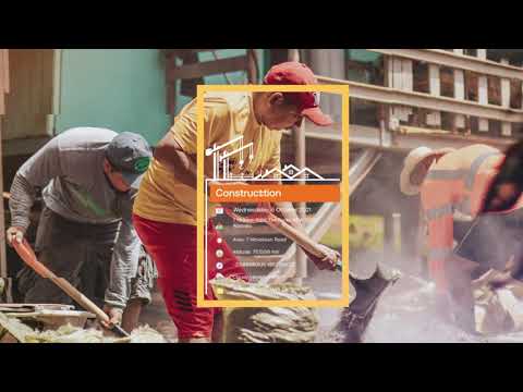
🔰Service Stamps: Perfect for tracking deliveries, tasks, and operations by capturing geotagged photos with precise timestamps and photos with location details.
🔰Field Stamps: Ideal for documenting outdoor projects, surveys, and site inspections, ensuring every geotag photo includes accurate geotag and timestamp information.
🔰Office Stamps: Useful for meetings, attendance tracking, and work records with customizable templates for geotagging photos and adding photos with location details.
⭐Main Stamp Fields in Geotag Photos & GPS Stamp Camera app include:
💠Logo: Add your brand/logo to photos for identification.
✒️Subject: Tag geotag photos with specific project names or categories.
🗓️Date Format: Customize date format (DD/MM/YYYY, etc.).
📍Location: Geotag photos with GPS coordinates & location.
🗺️Area: Record work area details for documentation.
🏔️Altitude: Capture altitude data for location precision.
🧭Compass: Include compass direction for orientation.
🌐Coordinates: Automatically add latitude-longitude for photo geotagging.
🌡️Temperature: Tag photos with current temperature details.
🌬️Wind Force: Document wind speed for environmental conditions.
🍃Air Quality: Capture air quality data for environmental checks.
👷Contractor: Tag photos with contractor details for accountability.
👨💼Supervisor: Document supervisor info for project oversight.
👨🏻🔧Worker: Identify workers captured in Geotag pictures.
📝Note: Add geo notes for additional context to geo-tagged photo.
⭐Geotagging Photos app for Every Need – Fieldwork, Travel, Office & More:
✔️Fieldwork Documentation
-Capture detailed photos with geotag and GPS camera with time stamp for surveying, construction, and land management.
✔️Engineering Work
-Track project progress with geotagging photos and documenting construction phases and technical details.
✔️Office Work & Meetings
-Capture meeting details, track attendance, and clock in/out times with geotagging photos app.
✔️Transportation & Delivery
-Document deliveries, monitor routes, and verify task completion with GPS Mapping Camera.
✔️Travel & Adventure
-Easily document journeys, capture moments and share adventures with geotagged photos.
✔️Work Reporting & Project Management
-Create detailed reports with geotagging photos to track progress and manage projects.
Auto Geotag Camera with GPS Stamps is perfect for professionals in various fields. Capture every detail with accurate location and time tagging to improve your geotagging photos app documentation and reporting.
📲 Download Geotag Photos with GPS Stamp Location Now!
📸 Capture. 🌍 Geotag. 🗂️ Report.
Take geotag photos with live GPS location and latitude-longitude using our Geotagging Photos app. Auto-add accurate geotags, timestamps, and location info to your photos and videos. Whether for fieldwork, engineering, transportation, or travel, Geotag Camera ensures every photo includes essential location details with latitude/longitude.
⭐Capture Work Reports Instantly with Pre-Built Templates:
🔰Service Stamps: Perfect for tracking deliveries, tasks, and operations by capturing geotagged photos with precise timestamps and photos with location details.
🔰Field Stamps: Ideal for documenting outdoor projects, surveys, and site inspections, ensuring every geotag photo includes accurate geotag and timestamp information.
🔰Office Stamps: Useful for meetings, attendance tracking, and work records with customizable templates for geotagging photos and adding photos with location details.
⭐Main Stamp Fields in Geotag Photos & GPS Stamp Camera app include:
💠Logo: Add your brand/logo to photos for identification.
✒️Subject: Tag geotag photos with specific project names or categories.
🗓️Date Format: Customize date format (DD/MM/YYYY, etc.).
📍Location: Geotag photos with GPS coordinates & location.
🗺️Area: Record work area details for documentation.
🏔️Altitude: Capture altitude data for location precision.
🧭Compass: Include compass direction for orientation.
🌐Coordinates: Automatically add latitude-longitude for photo geotagging.
🌡️Temperature: Tag photos with current temperature details.
🌬️Wind Force: Document wind speed for environmental conditions.
🍃Air Quality: Capture air quality data for environmental checks.
👷Contractor: Tag photos with contractor details for accountability.
👨💼Supervisor: Document supervisor info for project oversight.
👨🏻🔧Worker: Identify workers captured in Geotag pictures.
📝Note: Add geo notes for additional context to geo-tagged photo.
⭐Geotagging Photos app for Every Need – Fieldwork, Travel, Office & More:
✔️Fieldwork Documentation
-Capture detailed photos with geotag and GPS camera with time stamp for surveying, construction, and land management.
✔️Engineering Work
-Track project progress with geotagging photos and documenting construction phases and technical details.
✔️Office Work & Meetings
-Capture meeting details, track attendance, and clock in/out times with geotagging photos app.
✔️Transportation & Delivery
-Document deliveries, monitor routes, and verify task completion with GPS Mapping Camera.
✔️Travel & Adventure
-Easily document journeys, capture moments and share adventures with geotagged photos.
✔️Work Reporting & Project Management
-Create detailed reports with geotagging photos to track progress and manage projects.
Auto Geotag Camera with GPS Stamps is perfect for professionals in various fields. Capture every detail with accurate location and time tagging to improve your geotagging photos app documentation and reporting.
📲 Download Geotag Photos with GPS Stamp Location Now!
تاریخ بهروزرسانی
ایمنی با درک اینکه توسعهدهندگان چگونه دادههای شما را جمعآوری و همرسانی میکنند شروع میشود. شیوههای حفظ امنیت و حریم خصوصی دادهها ممکن است براساس استفاده، منطقه، و سن شما متفاوت باشد. توسعهدهنده این اطلاعات را ارائه کرده است و ممکن است آن را درطول زمان بهروزرسانی کند.

این برنامه ممکن است این نوع دادهها را با طرفهای سوم همرسانی کند
مکان

هیچ دادهای جمعآوری نمیشود
درباره نحوه اعلام جمعآوری دادهها توسط توسعهدهندگان بیشتر بدانید

دادهها هنگام جابهجایی رمزگذاری میشود

نمیتوان دادهها را حذف کرد
رتبهبندیها و مرورها
۴٫۲
۷۷۸ مرور

علی صنمی زاده
- پرچمگذاری بهعنوان نامناسب
۱۷ آذر ۱۴۰۰
عالی
پشتیبانی برنامه
درباره توسعهدهنده
SUSAMP INFOTECH
appsupport@susampinfotech.com
4th Floor, Shop No. 412 To 421, Parle Square, Ved Gurukul Road
Opp. Akshar Wadi, Dabholi
Surat, Gujarat 395004
India
+91 94996 35045


