
UN-ASIGN
5 Tsg.+
Downloads

Jedes Alter
info


Über diese App
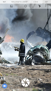
This UN-ASIGN application has been developed by AnsuR for crowd sourcing geo-tagged photos and text from areas affected by larger humanitarian disasters to the United Nations entity UNITAR/UNOSAT. Seconds after you send a geo-tagged photo it will be available in a map at the receiver side.
The input of in-situ visual information will help UNOSAT assess damages and situations from satellite imagery in particular and will help various entities in the UN-system conduct operations. Selected images and data provided via this application will be integrated into professional on-line mapping portals and will normally be made available to the public.
Contributors by definition will allow use of the images and data for non-commercial purposes related to managing the disasters they are related to. They will not be used commercially.
Images provided by the Crowd will help affected countries, UN, EC, Red Cross family and NGOs to make better and faster decisions in disaster management.
Please add text to describe the photos. Your input is being received at a UN server hosted by CERN in Geneva and images are being assessed by OCHA and UNITAR/UNOSAT, as the information is useful for both effective co-ordination as well as validation of satellite image analysis related to natural disasters.
The photos are automatically timestamped and geo-tagged (geo-pictures). GPS is most precise, but basically only works outdoors, hence the ASIGN solution also includes positioning via cellular (3G) and Wi-Fi networks.
Photos are compressed significantly to save time, cost and bandwidth, but higher resolution parts can be automatically requested later if needed, in which case the photo-provider is notified with an SMS if the phone number is properly registered. Please note how this is done.
UN-ASIGN has been developed by AnsuR, as part of a European FP7 Funded Project called GEO-PICTURES, and is being operated in collaboration with UNITAR/UNOSAT.
This application is a simplified version of ASIGN, that been developed by AnsuR as a professional tool for disaster management and early responders.
Aktualisiert am
Was die Sicherheit angeht, solltest du als Erstes verstehen, wie Entwickler deine Daten erheben und weitergeben. Die Datenschutz- und Sicherheitspraktiken können je nach deiner Verwendung, deiner Region und deinem Alter variieren. Diese Informationen wurden vom Entwickler zur Verfügung gestellt und können jederzeit von ihm geändert werden.

Keine Daten werden mit Drittunternehmen oder -organisationen geteilt

Diese App kann die folgenden Datentypen erheben
Standort, Personenbezogene Daten und 3 andere

Daten werden bei der Übertragung verschlüsselt

Du kannst das Löschen der Daten beantragen
Neuerungen
- Upgraded to use latest Android libraries
Support für diese App
Informationen zum Entwickler
Ansur Technologies AS
hakon@ansur.no
Martin Linges vei 25
1364 FORNEBU
Norway
+47 41 40 09 77


