Land Nav Assistant

4.1star
325 Rezensionen
50 Tsg.+
Downloads

Jedes Alter
info


Über diese App
Land Nav Assistant accepts MGRS (Military Grid) or Latitude / Longitude coordinates and visually navigates you to each point.
This app was designed with Army, Marine, and other military personnel in mind. Use it to correct your Land Nav technique by analyzing your pace count and tendency to veer left and right.
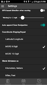
Available Input: 8 digit MGRS, 10 digit MGRS, Lat/Lon decimal, Lat/Lon dms, and map input.
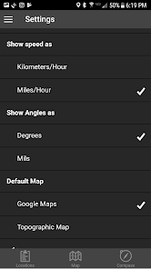
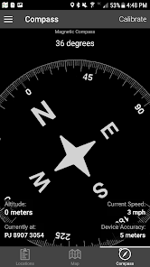
Angles: degrees or mils
Distance: meters/km or feet/miles
Speed: kph or mph
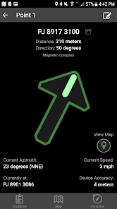
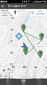
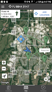
Use the simple arrow interface or map to direct you to your locations. Your distance, direction, speed, and bearing are shown as you navigate.
Long-tap anywhere on the map to get the coordinate for that location. Easily add locations via the Map interface.
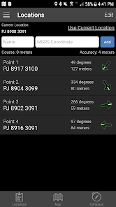
Plan your course by ordering points, or use the course optimization tool which will help you calculate the shortest path possible!
Get distance/direction between two points by tapping the path drawn between them.
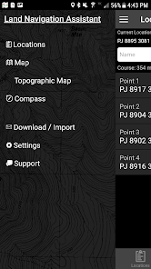
Satellite, Terrain, Road, and basic Topographic maps show you, your locations, and lets you enter in new ones.
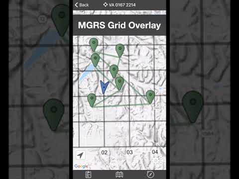
Overlay a 1000m or 100m MGRS grid anywhere on the map.
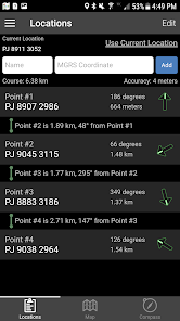
Displays distance/direction from your currentl location to all points, or between any two points.
Download your Locations as a spreadsheet to save anywhere, or to share with anyone you choose.
Import a large set of locations via the web import utility, available at: https://www.gammonapplications.com/land-navigation-services/import
This app uses the Military Grid Reference System (MGRS) and Latitude / Longitude.
Choose to display your locations as MGRS 10-digit, MGRS 8-digit, or LatLon Decimal.
D:M:S can be input in the format DD:MM:SS followed by the appropriate direction (NSWE). Default direction is N, W.
DO NOT use this application while learning Land Navigation. Land Navigation is a valuable skill, and should be mastered before using this application. Do not rely solely on this application for navigation, especially when lost. Always be aware of your surroundings.
This app was designed with Army, Marine, and other military personnel in mind. Use it to correct your Land Nav technique by analyzing your pace count and tendency to veer left and right.
Available Input: 8 digit MGRS, 10 digit MGRS, Lat/Lon decimal, Lat/Lon dms, and map input.
Angles: degrees or mils
Distance: meters/km or feet/miles
Speed: kph or mph
Use the simple arrow interface or map to direct you to your locations. Your distance, direction, speed, and bearing are shown as you navigate.
Long-tap anywhere on the map to get the coordinate for that location. Easily add locations via the Map interface.
Plan your course by ordering points, or use the course optimization tool which will help you calculate the shortest path possible!
Get distance/direction between two points by tapping the path drawn between them.
Satellite, Terrain, Road, and basic Topographic maps show you, your locations, and lets you enter in new ones.
Overlay a 1000m or 100m MGRS grid anywhere on the map.
Displays distance/direction from your currentl location to all points, or between any two points.
Download your Locations as a spreadsheet to save anywhere, or to share with anyone you choose.
Import a large set of locations via the web import utility, available at: https://www.gammonapplications.com/land-navigation-services/import
This app uses the Military Grid Reference System (MGRS) and Latitude / Longitude.
Choose to display your locations as MGRS 10-digit, MGRS 8-digit, or LatLon Decimal.
D:M:S can be input in the format DD:MM:SS followed by the appropriate direction (NSWE). Default direction is N, W.
DO NOT use this application while learning Land Navigation. Land Navigation is a valuable skill, and should be mastered before using this application. Do not rely solely on this application for navigation, especially when lost. Always be aware of your surroundings.
Aktualisiert am
Was die Sicherheit angeht, solltest du als Erstes verstehen, wie Entwickler deine Daten erheben und weitergeben. Die Datenschutz- und Sicherheitspraktiken können je nach deiner Verwendung, deiner Region und deinem Alter variieren. Diese Informationen wurden vom Entwickler zur Verfügung gestellt und können jederzeit von ihm geändert werden.


Bewertungen und Rezensionen
4.1
319 Rezensionen
Neuigkeiten
- Added a new map style option
- Fixed a bug that caused example locations to be added multiple times
- Fixed a bug that caused example locations to be added multiple times