
Edinburgh Bus Tracker
Enthält Werbung
1 Tsg.+
Downloads

Jedes Alter
info
Über diese App
Provide realtime arrival prediction for Edinburgh Bus
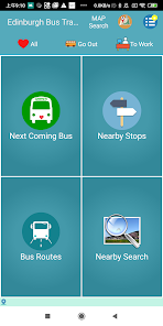
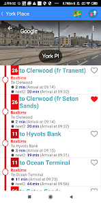
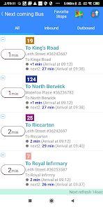
1. Next coming bus
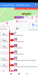
- Predict the most possible next coming bus base on your current location
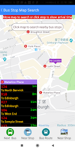
- Provide nearby stop locations in a map. Click on the map to select a specific stop. You can explore all bus routes via the stop
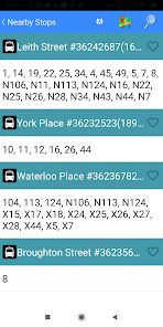
2. Nearby Stops
- Provid all nearby bus stops sorted by the distance from current location
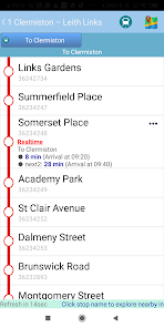
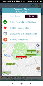
- Click on a specific bus stop to display all bus routes via the stop
- Click on a specific route to further display all stop sequence and their estimated arrival times
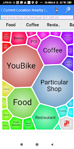
- By clicking on a specific stop, you can further explore the stop nearby POI, such as food, restaurants, attractions and other store information.
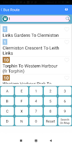
3. Bus Routes Information
- Searching specific bus information by using route#, stop#, or partial stop name
- Provide frequently used bus route for quickly selection.
4. Direction planning
- Provide the suggested traffic routes (walk, take bus, subway, train, etc.) between the desired departure and destination location
- Provide a well-planned route map to indicate the traffic types you need to use
- Use speech recognition to speed up the route planning
- Click on the destination to explore the nearby attractions around the destination, such as food, restaurants, attractions and other store information
- You can share the planned routes to a friend to his(her) LINE chat or EMAIL
5. Nearby POI Search
- Provide nearby POI search
- The POI categories include snacks, coffee snacks, restaurants, MRT station, Bike point, train station, attractions, hospitals, supermarkets, beauty salons, hotels, clothing stores, bars, shoe stores, Shopping malls, schools, flower shops, electrical shops, banks, travel agencies, bookstores, post offices, bicycle lines, steam locomotive, furniture, housing agents, pet shops, aquariums, etc.
- Use voice input to query specific stores such as McDonald's, Starbucks, ...
- Provide detailed information of a store, such as photos, rating score, address, URL,openning hours, comments, etc.
- Searching radius ranging from 500 meters to 7km can be set as your need
- Provide POI maps and street views. It also indicates the best route from current location (walking or cycling)
- Support search of cities or landmarks all over the world
- You can share POI information to a friend to his(her) LINE chat or EMAIL
1. Next coming bus
- Predict the most possible next coming bus base on your current location
- Provide nearby stop locations in a map. Click on the map to select a specific stop. You can explore all bus routes via the stop
2. Nearby Stops
- Provid all nearby bus stops sorted by the distance from current location
- Click on a specific bus stop to display all bus routes via the stop
- Click on a specific route to further display all stop sequence and their estimated arrival times
- By clicking on a specific stop, you can further explore the stop nearby POI, such as food, restaurants, attractions and other store information.
3. Bus Routes Information
- Searching specific bus information by using route#, stop#, or partial stop name
- Provide frequently used bus route for quickly selection.
4. Direction planning
- Provide the suggested traffic routes (walk, take bus, subway, train, etc.) between the desired departure and destination location
- Provide a well-planned route map to indicate the traffic types you need to use
- Use speech recognition to speed up the route planning
- Click on the destination to explore the nearby attractions around the destination, such as food, restaurants, attractions and other store information
- You can share the planned routes to a friend to his(her) LINE chat or EMAIL
5. Nearby POI Search
- Provide nearby POI search
- The POI categories include snacks, coffee snacks, restaurants, MRT station, Bike point, train station, attractions, hospitals, supermarkets, beauty salons, hotels, clothing stores, bars, shoe stores, Shopping malls, schools, flower shops, electrical shops, banks, travel agencies, bookstores, post offices, bicycle lines, steam locomotive, furniture, housing agents, pet shops, aquariums, etc.
- Use voice input to query specific stores such as McDonald's, Starbucks, ...
- Provide detailed information of a store, such as photos, rating score, address, URL,openning hours, comments, etc.
- Searching radius ranging from 500 meters to 7km can be set as your need
- Provide POI maps and street views. It also indicates the best route from current location (walking or cycling)
- Support search of cities or landmarks all over the world
- You can share POI information to a friend to his(her) LINE chat or EMAIL
Aktualisiert am
Was die Sicherheit angeht, solltest du als Erstes verstehen, wie Entwickler deine Daten erheben und weitergeben. Die Datenschutz- und Sicherheitspraktiken können je nach deiner Verwendung, deiner Region und deinem Alter variieren. Diese Informationen wurden vom Entwickler zur Verfügung gestellt und können jederzeit von ihm geändert werden.

Keine Daten werden mit Drittunternehmen oder -organisationen geteilt

Diese App kann die folgenden Datentypen erheben
App-Informationen und -Leistung und Geräte- oder andere IDs

Daten werden nicht verschlüsselt
Daten können nicht gelöscht werden
Neuerungen
Ver1.592 Update bus route data and support Android 15 functions(7/9)
Ver1.591 Add shortcut functions on long-pressing App icon.(5/31)
Ver1.581 Update bus route data.(3/25)
Ver1.576 Maintain App stability for reducing App not responding(ANR) rate.(2/25)
Ver1.569 Update bus route data.(1/15)
Ver1.550 Add driving bus list in bus route map.(10/26)
Ver1.547 Fixed server connection problem.(9/22)
Ver1.543 Update bus route data.(8/23)
Support für diese App
Informationen zum Entwickler
許志興
goder.hsu@gmail.com
Taiwan
undefined


