
Singapore MRT Map Route 新加坡地铁
4.2star
3.7 Tsg. Rezensionen
100 Tsg.+
Downloads

Jedes Alter
info


Über diese App
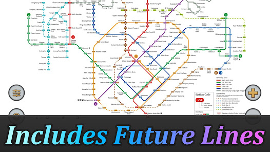
Added Thomson-East Coast Line (TE1 Woodlands North to Orchard) to the subway system.
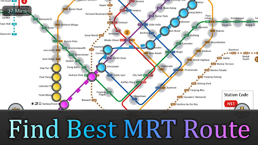
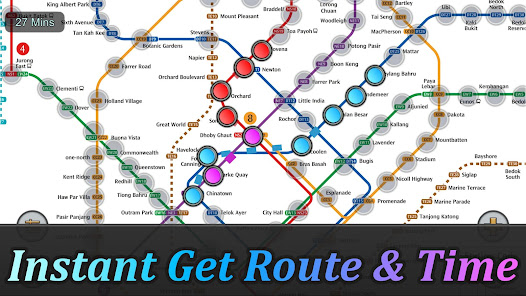
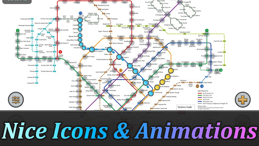
Singapore's MRT system is extending. By 2030, the MRT system will be more complex than you could image. It's good for all residents on our lovely island. But also will be a problem because we don't know how to travel the fastest when transfering stations.
Singapore MRT Map Route is designed to allows user to get the best route within a second. It will help you save a lot of time over years.
- View lastest Singapore MRT map
- Display the best route between two stations
- Automatically calculate estimated travel time
- Require no internet connection.
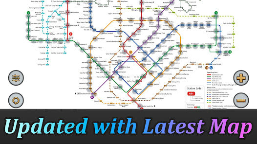
Updated to latest MRT system:
Downtown Line(Blue)
Bukit Panjang, Cashew, Hillview, Beauty World, King Albert Park, Sixth Avenue, Tan Kah Kee, Botanic Gardens, Stevens, Newton, Little India, Rochor, Bugis, Promenade, Bayfront, Downtown, Telok Ayer, Chinatown
Circle Line(Yellow)
Dhoby Ghaut, Bras Basah, Esplanade, Promenade, Nicoll Highway[C], Stadium, Mountbatten, Dakota, Paya Lebar, MacPherson, Tai Seng, Bartley, Serangoon, Lorong Chuan, Bishan, Marymount, Caldecott, Botanic Gardens, Farrer Road, Holland Village. Buona Vista, one-north, Kent Ridge, Haw Par Villa, Pasir Panjang, Labrador Park, Telok Blangah, HarbourFront
East West Line (Green)
Pasir Ris ,Tampines , Simei , Tanah Merah , Bedok , Kembangan , Eunos , Paya Lebar , Aljunied , Kallang , Lavender , Bugis , City Hall , Raffles Place , Tanjong Pagar , Outram Park , Tiong Bahru , Redhill , Queenstown , Commonwealth , Buona Vista , Dover ,Clementi , Jurong East , Chinese Garden , Lakeside , Boon Lay , Pioneer , Joo Koon, Expo,
Changi Airport
North South Line (Red)
Jurong East, Bukit Batok, Bukit Gombak, Choa Chu Kang, Yew Tee, Kranji, Marsiling, Woodlands, Admiralty, Sembawang, Canberra, Yishun, Khatib, Yio Chu Kang, Ang Mo Kio, Bishan, Braddell, Toa Payoh, Novena, Newton, Orchard, Somerset, Dhoby Ghaut, City Hall, Raffles Place, Marina Bay, Marina South Pier
North East Line (Purple)
HarbourFront, Outram Park, Chinatown, Clarke Quay, Dhoby Ghaut, Little India, Farrer Park, Boon Keng, Potong Pasir, Woodleigh, Serangoon, Kovan, Hougang, Buangkok, Sengkang, Punggol
Singapore's MRT system is extending. By 2030, the MRT system will be more complex than you could image. It's good for all residents on our lovely island. But also will be a problem because we don't know how to travel the fastest when transfering stations.
Singapore MRT Map Route is designed to allows user to get the best route within a second. It will help you save a lot of time over years.
- View lastest Singapore MRT map
- Display the best route between two stations
- Automatically calculate estimated travel time
- Require no internet connection.
Updated to latest MRT system:
Downtown Line(Blue)
Bukit Panjang, Cashew, Hillview, Beauty World, King Albert Park, Sixth Avenue, Tan Kah Kee, Botanic Gardens, Stevens, Newton, Little India, Rochor, Bugis, Promenade, Bayfront, Downtown, Telok Ayer, Chinatown
Circle Line(Yellow)
Dhoby Ghaut, Bras Basah, Esplanade, Promenade, Nicoll Highway[C], Stadium, Mountbatten, Dakota, Paya Lebar, MacPherson, Tai Seng, Bartley, Serangoon, Lorong Chuan, Bishan, Marymount, Caldecott, Botanic Gardens, Farrer Road, Holland Village. Buona Vista, one-north, Kent Ridge, Haw Par Villa, Pasir Panjang, Labrador Park, Telok Blangah, HarbourFront
East West Line (Green)
Pasir Ris ,Tampines , Simei , Tanah Merah , Bedok , Kembangan , Eunos , Paya Lebar , Aljunied , Kallang , Lavender , Bugis , City Hall , Raffles Place , Tanjong Pagar , Outram Park , Tiong Bahru , Redhill , Queenstown , Commonwealth , Buona Vista , Dover ,Clementi , Jurong East , Chinese Garden , Lakeside , Boon Lay , Pioneer , Joo Koon, Expo,
Changi Airport
North South Line (Red)
Jurong East, Bukit Batok, Bukit Gombak, Choa Chu Kang, Yew Tee, Kranji, Marsiling, Woodlands, Admiralty, Sembawang, Canberra, Yishun, Khatib, Yio Chu Kang, Ang Mo Kio, Bishan, Braddell, Toa Payoh, Novena, Newton, Orchard, Somerset, Dhoby Ghaut, City Hall, Raffles Place, Marina Bay, Marina South Pier
North East Line (Purple)
HarbourFront, Outram Park, Chinatown, Clarke Quay, Dhoby Ghaut, Little India, Farrer Park, Boon Keng, Potong Pasir, Woodleigh, Serangoon, Kovan, Hougang, Buangkok, Sengkang, Punggol
Aktualisiert am
Was die Sicherheit angeht, solltest du nachvollziehen, wie Entwickler deine Daten erheben und weitergeben. Die Datenschutz- und Sicherheitspraktiken können je nach Verwendung, Region und Alter des Nutzers variieren. Diese Informationen wurden vom Entwickler zur Verfügung gestellt und können jederzeit von ihm geändert werden.

Keine Daten werden mit Drittunternehmen oder -organisationen geteilt

Keine Daten erhoben
Bewertungen und Rezensionen
4.2
3.59 Tsg. Rezensionen
Neuigkeiten
- Added Thomson-East Coast Line (TE1 Woodlands North to Orchard) to the subway system.
- Optimized calculation speed to improve the overall performance of the application.
- Fixed known issues and bugs to enhance the stability and reliability of the application.


