
London offline map
5+
Downloads

Jedes Alter
info
Über diese App
Offline map of the historic city of London for tourist & business visitors. Download before you go and avoid expensive roaming charges. The map runs completely on your device; display with pan and zoom, routing, search, bookmark, everything. It does not use your data connection at all. Switch your phone function off if you want to.
No ads. All features fully functional on installation. No add-ons. No extra downloads.
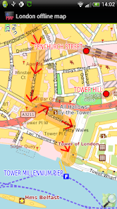
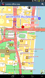
We focus on visitors, emphasizing historical and touristic points of interest. The map style is designed for outdoor use.
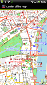
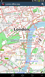
The map includes all of central London and the inner suburbs: east to Harrow, south to Kingston, north to Hendon. Gatwick and Heathrow Airports NOT included.
The map is based on OpenStreetMap data, https://www.openstreetmap.org. It continues to improve and we publish free app updates every few months with new information.
You can:
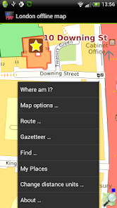
* find out where you are, if you have GPS.
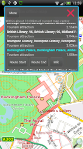
* show a route between any place for motor vehicle, foot or bicycle; even without a GPS device.
* display simple turn-by-turn navigation [*].
* search for places
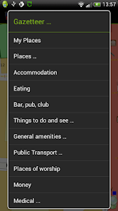
* display gazetteer lists of commonly needed places like hotels, eating places, shops, banks, things to see and do, golf courses, medical facilities. Show how to get there from your current location.
* bookmark places like your hotel for easy return navigation.
* * Navigation will show you an indicative route and can be configured for car, bicycle or foot. The developers provide it without any guarantee that it is always correct. For example, OpenStreetMap data does not always have turn restrictions - places where it is illegal to turn. Use with care and above all look out for and obey road signs.
We hope it does not happen to you but: Like most small developers, we cannot test a wide variety of phones and tablets. If you have trouble running the application, do email us and we will try to help and/or refund you.
No ads. All features fully functional on installation. No add-ons. No extra downloads.
We focus on visitors, emphasizing historical and touristic points of interest. The map style is designed for outdoor use.
The map includes all of central London and the inner suburbs: east to Harrow, south to Kingston, north to Hendon. Gatwick and Heathrow Airports NOT included.
The map is based on OpenStreetMap data, https://www.openstreetmap.org. It continues to improve and we publish free app updates every few months with new information.
You can:
* find out where you are, if you have GPS.
* show a route between any place for motor vehicle, foot or bicycle; even without a GPS device.
* display simple turn-by-turn navigation [*].
* search for places
* display gazetteer lists of commonly needed places like hotels, eating places, shops, banks, things to see and do, golf courses, medical facilities. Show how to get there from your current location.
* bookmark places like your hotel for easy return navigation.
* * Navigation will show you an indicative route and can be configured for car, bicycle or foot. The developers provide it without any guarantee that it is always correct. For example, OpenStreetMap data does not always have turn restrictions - places where it is illegal to turn. Use with care and above all look out for and obey road signs.
We hope it does not happen to you but: Like most small developers, we cannot test a wide variety of phones and tablets. If you have trouble running the application, do email us and we will try to help and/or refund you.
Aktualisiert am
Was die Sicherheit angeht, solltest du als Erstes verstehen, wie Entwickler deine Daten erheben und weitergeben. Die Datenschutz- und Sicherheitspraktiken können je nach deiner Verwendung, deiner Region und deinem Alter variieren. Diese Informationen wurden vom Entwickler zur Verfügung gestellt und können jederzeit von ihm geändert werden.

Keine Daten werden mit Drittunternehmen oder -organisationen geteilt

Diese App kann die folgenden Datentypen erheben
App-Aktivitäten, App-Informationen und -Leistung und Geräte- oder andere IDs

Daten werden bei der Übertragung verschlüsselt

Daten können nicht gelöscht werden
Neuigkeiten
- Latest OpenStreetMap data
- Android 10 compatibility
- Removed "Advanced Find" menu item to simplify the app, contact us via our Developer Email on the Google Play Store if you want this back.
- Added Crashlytics. If the app crashes, information about the crash is automatically sent to us. No personal data is sent. Your location is not sent.
- Ski runs and ski lifts now show where applicable
- Reservoir dams now show
- Some map style tweaks, e.g service roads thinner to contrast them better.
Support für diese App
Informationen zum Entwickler
Michael Collinson
mike@ayeltd.biz
Rialavägen 62
186 97 Brottby
Sweden
undefined


