
Treetracker 2.2 by Greenstand
4.0star
69 Rezensionen
10 Tsg.+
Downloads

Jedes Alter
info

Über diese App
This tree tracking and mapping tool supports people and organizations that plant, monitor, and protect trees.
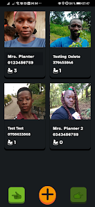
It's most basic function is designed to help planters keep track of their trees. More advanced features allow organizations to display tree data by embedding tree-maps on webpages. It is also part of a framework that enables organizations to employ people to plant on a per tree survival bases and allows individuals and organizations to sell and trade their restoration impact.
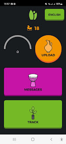
The 'Add Tree' feature takes a geo-tagged picture and automatically puts tree markers on a global map. Your trees upload to www.treetracker.org. Greenstand can provide custom maps showing your trees only or remove your trees from public view. Users can request access to the Dashboard in order to verify the uploaded trees by contacting info@greenstand.org.
** NOTE: Your app's default setting requires ten-meter GPS accuracy.
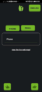
The app is designed to verify user accounts for the sale of tree-based impact and requires an image-based login each time it is used.
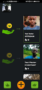
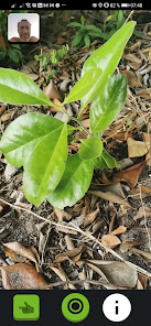
** IMPORTANT CHANGES: Tracking a tree involves taking a photo of the tree/seedling along with its location data (GPS co-ordinates). On entering the tree tracking mode in the app, a screen to select the grower is presented. Once the grower is selected, the camera screen is activated. On clicking the green button the app enters Convergence mode with a green processing circle appearing in the center of the screen. Note that during this convergence mode the image of the tree is not immediately captured. Instead a stream of location data from the device is processed to determine its accuracy and the moment the location data stays within a close range the convergence is complete and the image of the tree is captured. The duration of the convergence may take anywhere between couple of seconds to 60 seconds depending on the device. The motivation for this convergence is to associate precise location data to the captured tree and thus differs from other camera apps where clicking on the camera button immediately captures the image. Please comment on this feature which adds to the tracking time but hugely improves data accuracy.
Contact the Greenstand Team at info@greenstand.org for more information, custom modifications, or other versions of this open-source software. For the full details of how this application can benefit your tree planting project reach out to us or visit our website www.greenstand.org
It's most basic function is designed to help planters keep track of their trees. More advanced features allow organizations to display tree data by embedding tree-maps on webpages. It is also part of a framework that enables organizations to employ people to plant on a per tree survival bases and allows individuals and organizations to sell and trade their restoration impact.
The 'Add Tree' feature takes a geo-tagged picture and automatically puts tree markers on a global map. Your trees upload to www.treetracker.org. Greenstand can provide custom maps showing your trees only or remove your trees from public view. Users can request access to the Dashboard in order to verify the uploaded trees by contacting info@greenstand.org.
** NOTE: Your app's default setting requires ten-meter GPS accuracy.
The app is designed to verify user accounts for the sale of tree-based impact and requires an image-based login each time it is used.
** IMPORTANT CHANGES: Tracking a tree involves taking a photo of the tree/seedling along with its location data (GPS co-ordinates). On entering the tree tracking mode in the app, a screen to select the grower is presented. Once the grower is selected, the camera screen is activated. On clicking the green button the app enters Convergence mode with a green processing circle appearing in the center of the screen. Note that during this convergence mode the image of the tree is not immediately captured. Instead a stream of location data from the device is processed to determine its accuracy and the moment the location data stays within a close range the convergence is complete and the image of the tree is captured. The duration of the convergence may take anywhere between couple of seconds to 60 seconds depending on the device. The motivation for this convergence is to associate precise location data to the captured tree and thus differs from other camera apps where clicking on the camera button immediately captures the image. Please comment on this feature which adds to the tracking time but hugely improves data accuracy.
Contact the Greenstand Team at info@greenstand.org for more information, custom modifications, or other versions of this open-source software. For the full details of how this application can benefit your tree planting project reach out to us or visit our website www.greenstand.org
Aktualisiert am
Was die Sicherheit angeht, solltest du als Erstes verstehen, wie Entwickler deine Daten erheben und weitergeben. Die Datenschutz- und Sicherheitspraktiken können je nach deiner Verwendung, deiner Region und deinem Alter variieren. Diese Informationen wurden vom Entwickler zur Verfügung gestellt und können jederzeit von ihm geändert werden.

Keine Daten werden mit Drittunternehmen oder -organisationen geteilt

Diese App kann die folgenden Datentypen erheben
Standort, Personenbezogene Daten und 3 andere

Daten werden bei der Übertragung verschlüsselt

Du kannst das Löschen der Daten beantragen
Bewertungen und Rezensionen
4.0
69 Rezensionen
Neuerungen
A emergency rollback from our 2.2.0 because of serious bug.
Will try to release our 2.2 soon
Will try to release our 2.2 soon
Support für diese App
Informationen zum Entwickler
Greenstand
info@greenstand.org
721 Depot Dr Fl 2
Anchorage, AK 99501
United States
+1 302-659-7207