
3D Map

1 Tsg.+
Downloads

Jedes Alter
info

Über diese App
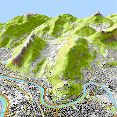
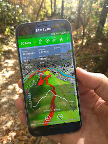
3D Map displays Maps in 3D with offline mode with world wide coverage.
Very useful on trails or for outdoors activities.
Totally compatible with *offline* mode : you can go and explore back-country without to worry.
All downloaded data, are available when your are off-line !
3D Map has been designed to allow simple terrain navigation.
GPS positioning and sensors make it possible to locate in 3D space.
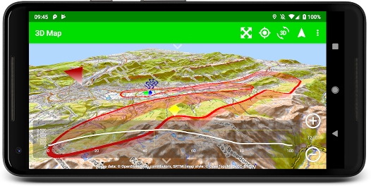
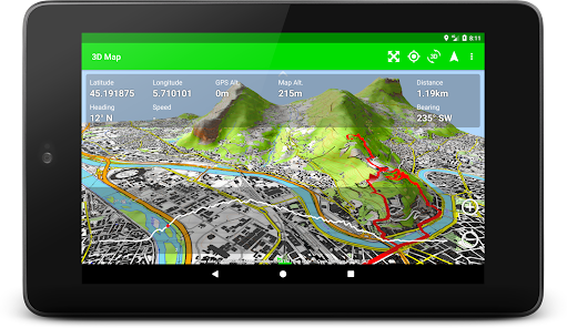
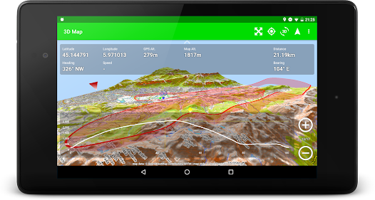
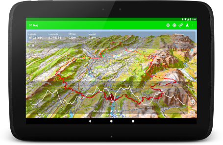
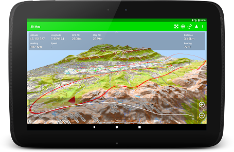
Coupled with a rendering engine, the map displays in 3D. Mountains are not flat terrain any more !
With sensors, you'll see the map moving at 1st person view.
Make a 360° around and you will see the map turning with you.
The map follows what you are looking !
- Supported Functionalities :
* 3D Rendering engine (2D mode available),
* Zoom scale : change zoom level,
* Inner Zoom : free zoom inside a zoom level,
* Free 3D moving,
* GPS current location,
* Current map altitude,
* Heading,
* Speed,
* Follow mode (GPS),
* Augmented reality mode with sensors and compass,
* Support of magnetic declination,
* Different map orientation : north, compass, GPS or manual,
* Distance measurement,
* Share your current location,
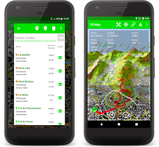
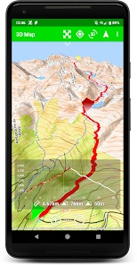
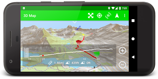
* View tracks / Waypoints in 3D or 2D (KML or GPX) (see https://youtu.be/paaTniKe38M),
* Reverse current track,
* Altimetric profile of tracks,
* Track proximity detection,
* Off-Track distance,
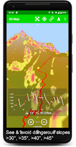
* Slope % or ° calculation,
* Worldwide slopes map : 30°, 35°, 40°, 45° ,
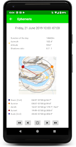
* Ephemeris : Sun trajectory and position with information on sunrise and sunset, ... everywhere / everytime,
* Search a place (require internet),
* Markers Management : create & edit your own markers. View them on the map,
* Area download,
* SDCard support,
* Embedded documentation,
- Currently not supported :
* No navigation system,
* No road navigation features,
* No track recording,
However you can load a track (GPX or KML) and the app will follow you on the track as you progress with updated information on your progress.
- Performances & Autonomy :
3D Map has been designed and optimized for 3D mode.
The application takes advantage of available CPU core and also GPU.
Multiple cores will do the job faster and will consume less battery.
From a storage point of view, the difference with a 2D map is marginal.
Once data has been downloaded (by WIFI for best performance), the application is as fast as a video game.
A trade-of had been made to guaranty a good fidelity to performance ratio that should allows a day of use.
Tested on 6+ hours trails in Glacier National Park.
Very useful on trails or for outdoors activities.
Totally compatible with *offline* mode : you can go and explore back-country without to worry.
All downloaded data, are available when your are off-line !
3D Map has been designed to allow simple terrain navigation.
GPS positioning and sensors make it possible to locate in 3D space.
Coupled with a rendering engine, the map displays in 3D. Mountains are not flat terrain any more !
With sensors, you'll see the map moving at 1st person view.
Make a 360° around and you will see the map turning with you.
The map follows what you are looking !
- Supported Functionalities :
* 3D Rendering engine (2D mode available),
* Zoom scale : change zoom level,
* Inner Zoom : free zoom inside a zoom level,
* Free 3D moving,
* GPS current location,
* Current map altitude,
* Heading,
* Speed,
* Follow mode (GPS),
* Augmented reality mode with sensors and compass,
* Support of magnetic declination,
* Different map orientation : north, compass, GPS or manual,
* Distance measurement,
* Share your current location,
* View tracks / Waypoints in 3D or 2D (KML or GPX) (see https://youtu.be/paaTniKe38M),
* Reverse current track,
* Altimetric profile of tracks,
* Track proximity detection,
* Off-Track distance,
* Slope % or ° calculation,
* Worldwide slopes map : 30°, 35°, 40°, 45° ,
* Ephemeris : Sun trajectory and position with information on sunrise and sunset, ... everywhere / everytime,
* Search a place (require internet),
* Markers Management : create & edit your own markers. View them on the map,
* Area download,
* SDCard support,
* Embedded documentation,
- Currently not supported :
* No navigation system,
* No road navigation features,
* No track recording,
However you can load a track (GPX or KML) and the app will follow you on the track as you progress with updated information on your progress.
- Performances & Autonomy :
3D Map has been designed and optimized for 3D mode.
The application takes advantage of available CPU core and also GPU.
Multiple cores will do the job faster and will consume less battery.
From a storage point of view, the difference with a 2D map is marginal.
Once data has been downloaded (by WIFI for best performance), the application is as fast as a video game.
A trade-of had been made to guaranty a good fidelity to performance ratio that should allows a day of use.
Tested on 6+ hours trails in Glacier National Park.
Aktualisiert am
Was die Sicherheit angeht, solltest du als Erstes verstehen, wie Entwickler deine Daten erheben und weitergeben. Die Datenschutz- und Sicherheitspraktiken können je nach deiner Verwendung, deiner Region und deinem Alter variieren. Diese Informationen wurden vom Entwickler zur Verfügung gestellt und können jederzeit von ihm geändert werden.

Keine Daten werden mit Drittunternehmen oder -organisationen geteilt

Keine Daten erhoben

Daten werden nicht verschlüsselt
Daten können nicht gelöscht werden
Neuigkeiten
- Small fixes and improvements.