
GPS Waypoints
広告が表示されますアプリ内購入あり
3.9star
1730 件のレビュー
50万+
ダウンロード

全ユーザー対象
info
このアプリについて
専門家と個人の両方で使用するための多目的マッピングおよび測量ツール。このツールは、農業、森林管理、インフラストラクチャのメンテナンス(道路や電気ネットワークなど)、都市計画と不動産、緊急時のマッピングなど、いくつかの専門的な土地ベースの測量活動で役立ちます。また、ハイキング、ランニング、ウォーキング、旅行、ジオキャッシングなどの個人的なアウトドアアクティビティにも使用されます。
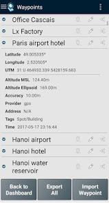
アプリケーションは、ポイント(関心のあるポイントなど)とパス(ポイントのシーケンス)を収集して、マッピングおよび測量アクティビティを実行します。精度情報で取得したポイントは、ユーザーが特定のタグで分類したり、写真で特徴づけたりすることができます。パスは、新しく取得されたポイントの時間シーケンスとして(たとえば、トラックを記録するために)作成されるか、または既存のポイントとともに(たとえば、ルートを作成するために)作成されます。パスを使用すると、距離を測定でき、閉じている場合はポリゴンを形成して、面積と周囲長を決定できます。ポイントとパスの両方をKML、GPX、CSVファイルにエクスポートできるため、地理空間ツールを使用して外部で処理できます。
このアプリケーションは、モバイルデバイスの内部GPS受信機(通常は精度が3mを超える)を使用するか、プロのユーザーがNMEAストリーム形式と互換性のあるBluetooth外部GNSS受信機(センチメートルレベルの精度のRTK受信機など)でより高い精度を達成できるようにします。サポートされている外部レシーバーのいくつかの例を以下に示します。
このアプリケーションには、次の機能が含まれています。
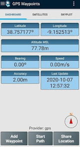
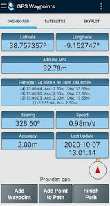
-正確なナビゲーション情報で現在位置を取得します。
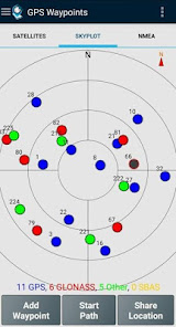
-アクティブで可視の衛星(GPS、GLONASS、GALILEO、BEIDOUなど)の詳細を提供します。
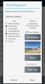
-正確な情報でポイントを作成し、タグで分類し、写真を添付し、座標を人間が読める形式の住所に変換します(逆ジオコーディング)。
-地理座標(緯度、経度)から、または住所/興味のある地点を検索して(ジオコーディング)、ポイントをインポートします。
-ポイントのシーケンスを手動または自動で取得してパスを作成します。
-既存のポイントからパスをインポートします。
-ポイントとパスを分類するためのカスタムタグを使用して調査のテーマを作成します
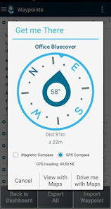
-磁気コンパスまたはGPSコンパスを使用して、現在の位置からポイントとパスまでの方向と距離を取得します。
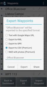
-ポイントとパスをKMLおよびGPXファイル形式にエクスポートします。
-他のアプリケーション(Dropbox / Googleドライブなど)とデータを共有します。
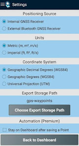
-内部レシーバーまたは外部レシーバーを使用して、ポジショニングソースを構成します。
プレミアムサブスクリプションには、次の専門的な機能が含まれています。
-ユーザーのデータをバックアップおよび復元します(1つのハンドセットから別のハンドセットにデータを転送することもできます)。
-ウェイポイントとパスをCSVファイル形式にエクスポートします。
-写真付きのウェイポイントをKMZファイルにエクスポートする
-CSVファイルとGPXファイルから複数のポイントとパスをインポートします。
-作成時間、名前、近接度でポイントとパスを並べ替えてフィルタリングします。
-衛星信号分析と干渉検出。
マップ機能は、オープンストリートマップでポイント、パス、ポリゴンを選択して視覚化できる追加の有料機能です。
内部モバイルレシーバーに加えて、現在のバージョンは次の外部レシーバーで動作することが知られています。BadElf GNSS Surveyor;ガーミングロ; Navilock BT-821G; Qstarz BT-Q818XT; Trimple R1; ubloxF9P。
別の外部レシーバーでアプリケーションのテストに成功した場合は、このリストを拡張するために、ユーザーまたはメーカーとしてフィードバックを提供してください。
詳細については、当社のサイト(https://www.bluecover.pt/gps-waypoints)を確認し、完全なオファーの詳細を入手してください。
-無料およびプレミアム機能(https://www.bluecover.pt/gps-waypoints/features)
-GISUY受信機(https://www.bluecover.pt/gisuy-gnss-receiver/)
-エンタープライズ(https://www.bluecover.pt/gps-waypoints/enterprise-version/)
アプリケーションは、ポイント(関心のあるポイントなど)とパス(ポイントのシーケンス)を収集して、マッピングおよび測量アクティビティを実行します。精度情報で取得したポイントは、ユーザーが特定のタグで分類したり、写真で特徴づけたりすることができます。パスは、新しく取得されたポイントの時間シーケンスとして(たとえば、トラックを記録するために)作成されるか、または既存のポイントとともに(たとえば、ルートを作成するために)作成されます。パスを使用すると、距離を測定でき、閉じている場合はポリゴンを形成して、面積と周囲長を決定できます。ポイントとパスの両方をKML、GPX、CSVファイルにエクスポートできるため、地理空間ツールを使用して外部で処理できます。
このアプリケーションは、モバイルデバイスの内部GPS受信機(通常は精度が3mを超える)を使用するか、プロのユーザーがNMEAストリーム形式と互換性のあるBluetooth外部GNSS受信機(センチメートルレベルの精度のRTK受信機など)でより高い精度を達成できるようにします。サポートされている外部レシーバーのいくつかの例を以下に示します。
このアプリケーションには、次の機能が含まれています。
-正確なナビゲーション情報で現在位置を取得します。
-アクティブで可視の衛星(GPS、GLONASS、GALILEO、BEIDOUなど)の詳細を提供します。
-正確な情報でポイントを作成し、タグで分類し、写真を添付し、座標を人間が読める形式の住所に変換します(逆ジオコーディング)。
-地理座標(緯度、経度)から、または住所/興味のある地点を検索して(ジオコーディング)、ポイントをインポートします。
-ポイントのシーケンスを手動または自動で取得してパスを作成します。
-既存のポイントからパスをインポートします。
-ポイントとパスを分類するためのカスタムタグを使用して調査のテーマを作成します
-磁気コンパスまたはGPSコンパスを使用して、現在の位置からポイントとパスまでの方向と距離を取得します。
-ポイントとパスをKMLおよびGPXファイル形式にエクスポートします。
-他のアプリケーション(Dropbox / Googleドライブなど)とデータを共有します。
-内部レシーバーまたは外部レシーバーを使用して、ポジショニングソースを構成します。
プレミアムサブスクリプションには、次の専門的な機能が含まれています。
-ユーザーのデータをバックアップおよび復元します(1つのハンドセットから別のハンドセットにデータを転送することもできます)。
-ウェイポイントとパスをCSVファイル形式にエクスポートします。
-写真付きのウェイポイントをKMZファイルにエクスポートする
-CSVファイルとGPXファイルから複数のポイントとパスをインポートします。
-作成時間、名前、近接度でポイントとパスを並べ替えてフィルタリングします。
-衛星信号分析と干渉検出。
マップ機能は、オープンストリートマップでポイント、パス、ポリゴンを選択して視覚化できる追加の有料機能です。
内部モバイルレシーバーに加えて、現在のバージョンは次の外部レシーバーで動作することが知られています。BadElf GNSS Surveyor;ガーミングロ; Navilock BT-821G; Qstarz BT-Q818XT; Trimple R1; ubloxF9P。
別の外部レシーバーでアプリケーションのテストに成功した場合は、このリストを拡張するために、ユーザーまたはメーカーとしてフィードバックを提供してください。
詳細については、当社のサイト(https://www.bluecover.pt/gps-waypoints)を確認し、完全なオファーの詳細を入手してください。
-無料およびプレミアム機能(https://www.bluecover.pt/gps-waypoints/features)
-GISUY受信機(https://www.bluecover.pt/gisuy-gnss-receiver/)
-エンタープライズ(https://www.bluecover.pt/gps-waypoints/enterprise-version/)
最終更新日
データの安全は、デベロッパーによるユーザーデータの収集、共有方法を理解することから始まります。データのプライバシーとセキュリティ対策は、アプリの使用方法、ユーザーの年齢やお住まいの地域によって異なることがあります。この情報はデベロッパーから提供されたもので、更新されることがあります。


評価とレビュー
3.9
1680 件のレビュー
新機能
Version 3.16
- Autopath improvements (inc trigger by distance)
- Edit Points and Paths on map (Maps)
- High resolution Satellite basemap added (Maps)
- Ruler from map with imperial metrics (Maps)
- EO images improvements (Maps)
Version 3.15
- Add manual Points and draw Paths on map (Maps)
- Ruler for measurements (Maps)
- Line charts in time from multi-selected Paths
アプリのサポート
phone
電話番号
+351932526378
デベロッパーについて
BLUECOVER - TECHNOLOGIES, LDA
info@bluecover.pt
AVENIDA DO BRASIL, 1 1ºESQ.
7300-068 PORTALEGRE (PORTALEGRE )
Portugal
+351 932 526 378


