

MapItFast- Field-based Mapping

4,0star
73 avis
10K+
Téléchargements

Tout public
info


À propos de l'application
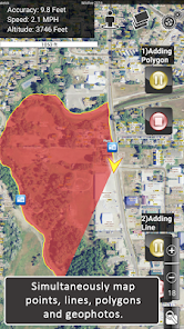
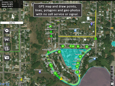
MapItFast transforms your phone or tablet into a powerful field mapping and data collection tool—even when you’re off the grid. Quickly create points, lines, polygons, and geophotos with a single tap with no GIS expertise required.
Key Free Features:
• Tap the icon to map objects instantly via GPS, or long-press to draw them by hand.
• Capture geophotos, measure distances, and calculate areas in real time.
• Pause or resume GPS tracking at any moment, and work on multiple lines or polygons simultaneously.
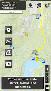
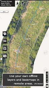
• Choose from aerial, street, and topo basemaps for a clear reference in any environment.
MapItFast Professional
Upgrade to the paid version for enterprise-level functionality and organize your work into projects, add custom basemaps and digital forms, and automatically sync everything to your private cloud account. MapItFast Professional includes web-based mapping features that seamlessly synchronize projects and user data across Android and iOS devices, fostering collaboration on unlimited projects and enabling custom form creation.
Key Paid Features
• Cloud-Based Sync: Access maps and data across devices and on the web.
• Real-Time Collaboration: A web portal shows projects, users, and updates as they happen.
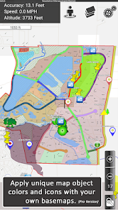
• Custom Maps & Symbology: Easily load and distribute your own mapping styles.
• Integrated Forms: Add attributes directly to map objects in the app.
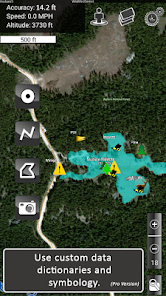
• Symbol Triggers: Auto-update map symbols as forms are completed.
• Custom Reports: Generate branded PDF or email reports with maps, photos, and form data.
• Advanced GIS Tools: Work with buffers, splits, donuts, and more.
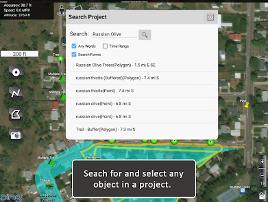
• Flexible Data Management: Search, sort, edit, copy, and move objects across projects.
• Shapefile Import/Export: Bring in shapefiles or export to KMZ, SHP, and GPX.
• Two-Way Sync: Real-time updates between field devices and your online account.
• User Permissions: Control project access and roles at individual or group levels.
Extend Your Capabilities
Enhance MapItFast’s capabilities with AgTerra’s hardware devices for real-time equipment activity tracking and mapping:
• SprayLogger: Automate pesticide application data logging and generate detailed reports.
• SnapMapper: Quickly create points and lines in MapItFast from any mechanical switch.
MapItFast is Perfect for Agriculture and Natural Resource Entities Performing:
• Vegetation management & pesticide reporting
• Mosquito trap inspection & vector control
• Field surveys & inspections
• Crop scouting
• Wildfire/disaster response & prevention
• Rangeland & water management
• Utilities & forestry operations
Simplify your field mapping process and streamline data management across your team or organization. Learn more about all our solutions at www.agterra.com.
Key Free Features:
• Tap the icon to map objects instantly via GPS, or long-press to draw them by hand.
• Capture geophotos, measure distances, and calculate areas in real time.
• Pause or resume GPS tracking at any moment, and work on multiple lines or polygons simultaneously.
• Choose from aerial, street, and topo basemaps for a clear reference in any environment.
MapItFast Professional
Upgrade to the paid version for enterprise-level functionality and organize your work into projects, add custom basemaps and digital forms, and automatically sync everything to your private cloud account. MapItFast Professional includes web-based mapping features that seamlessly synchronize projects and user data across Android and iOS devices, fostering collaboration on unlimited projects and enabling custom form creation.
Key Paid Features
• Cloud-Based Sync: Access maps and data across devices and on the web.
• Real-Time Collaboration: A web portal shows projects, users, and updates as they happen.
• Custom Maps & Symbology: Easily load and distribute your own mapping styles.
• Integrated Forms: Add attributes directly to map objects in the app.
• Symbol Triggers: Auto-update map symbols as forms are completed.
• Custom Reports: Generate branded PDF or email reports with maps, photos, and form data.
• Advanced GIS Tools: Work with buffers, splits, donuts, and more.
• Flexible Data Management: Search, sort, edit, copy, and move objects across projects.
• Shapefile Import/Export: Bring in shapefiles or export to KMZ, SHP, and GPX.
• Two-Way Sync: Real-time updates between field devices and your online account.
• User Permissions: Control project access and roles at individual or group levels.
Extend Your Capabilities
Enhance MapItFast’s capabilities with AgTerra’s hardware devices for real-time equipment activity tracking and mapping:
• SprayLogger: Automate pesticide application data logging and generate detailed reports.
• SnapMapper: Quickly create points and lines in MapItFast from any mechanical switch.
MapItFast is Perfect for Agriculture and Natural Resource Entities Performing:
• Vegetation management & pesticide reporting
• Mosquito trap inspection & vector control
• Field surveys & inspections
• Crop scouting
• Wildfire/disaster response & prevention
• Rangeland & water management
• Utilities & forestry operations
Simplify your field mapping process and streamline data management across your team or organization. Learn more about all our solutions at www.agterra.com.
Date de mise à jour
La sécurité, c'est d'abord comprendre comment les développeurs collectent et partagent vos données. Les pratiques concernant leur confidentialité et leur protection peuvent varier selon votre utilisation, votre région et votre âge. Le développeur a fourni ces informations et peut les modifier ultérieurement.

Aucune donnée partagée avec des tiers
En savoir plus sur la manière dont les développeurs déclarent le partage

Cette appli peut recueillir ces types de données
Position, Photos et vidéos

Les données sont chiffrées lors de leur transfert

Vous pouvez demander la suppression des données
Notes et avis
4,2
50 avis
Nouveautés
- UI layout improvements for small screens
- Offline layerset storage optimizations
- Offline layerset storage optimizations
Assistance de l'appli
phone
Numéro de téléphone
+13076731050
À propos du développeur
Agterra Technologies, Inc.
ratherton@agterra.com
212 W Burkitt St
Sheridan, WY 82801
United States
+1 307-673-1050
