Latin America Topo Maps
Contient des annoncesAchats via l'appli
4,6star
2,15K avis
100K+
Téléchargements

Tout public
info


À propos de l'application
Easy to use outdoor navigation app with free access to topographic maps for most parts of Latin America !
Choose between lots of map layers (topogrpahic maps, aerial images, nautical charts, ...) to plan the perfect trip and
turn your Andoid Phone/Tablet into an outdoor GPS for offline trips into the backcountry.
*** Note: Please use OpenStreetMap, Google or Bing layers if you need most recent maps ! ***
Add easily maps from other sources (GeoPDF, GeoTiff, Online Map Services like WMS, ...)
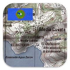
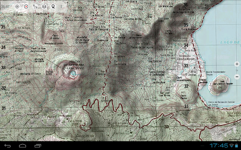
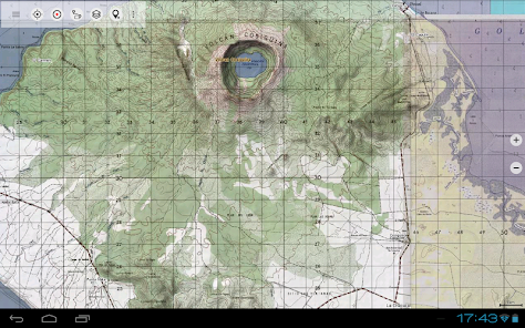
Worldwide accurate and detailed Maps
Available topographic map layers for Latin America:
• Mexico: INEGI Maps 1:20.000 - 1:250.000. Over 7.000 maps
• Brazil: 1:25.000 (ca. 15%), 1:50.000 (ca.30%), 1:100.000 (ca 75%), 1:250.000 (ca. 90%)
• Argentina: 1:50.000 (ca. 30%), 1:100.000 (ca. 70%), 1:250.000 (100%)
• Paraguay: 1:100.000 (ca. 80%)
• Peru: 1:25.000 (ca. 20%), 1:50.000 (ca. 15%), 1:100.000 (100%),
• Bolivien: 1:100.000 (ca. 45%)
• Chile: 1:250.000 (100%)
• Guatemala 1:50.000 (100%)
• Honduras 1:50.000 (100%)
• El Salvador 1:50.000 (100%)
• Nicaragua 1:50.000 (100%)
• Belize 1:250.000 (100%)
• Costa Rica 1:250.000 (100%)
• Panama 1:250.000 (100%)
• Haiti 1:50.000 (100%)
• Dominican Republic 1:50.000 (100%)
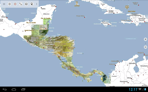
Worldwide basemap layers:
• OpenStreetMaps (5 different map layouts), also downloadable in space saving vectorformat
• Google Maps (Satellite images, Road- and Terrain-Map)
• Bing Maps (Satellite images, Road-Map)
• Waze Roads
• Earth At Night
Configure a basemap layer as an overlay and utilize a transparency fader to seamlessly compare maps with each other.
Add maps from other sources:
• Import raster maps in GeoPDF, GeoTiff, MBTiles or Ozi (Oziexplorer OZF2 & OZF3)
• Add web mapping services as WMS or WMTS/Tileserver
• Import OpenStreetMaps in Vectorformat, eg complete USA for just some GBs
Available worldwide overlays:
• Hillshading overlay
• 20m Contourlines
• OpenSeaMap
There is no perfect map. Toggle between the different map layers or use the compare maps feature to find the most interesting route. Especially the old topo maps contain many small pathes or other features that are missing on modern maps.
Main features for outdoor-navigation:
• Download map data for OFFLINE USAGE
• Measure pathes and aereas
• Create and edit Waypoints
• GoTo-Waypoint-Navigation
• Create and edit Routes
• Route-Navigation (Point-to-Point Navigation)
• Auto-Routing: Routes calculated on OpenStreetMap data with profiles for walking, bicycle or mountainbike
• Track Recording (with speed, elevation and accuracy profile)
• Tripmaster with fields for odometer, average speed, bearing, elevation, etc.
• GPX/KML/KMZ Import/Export
• Search (placenames, POIs, streets)
• Get elevation and distance
• Customizable datafields in Map View and Tripmaster (e.g. Speed, Distance, Compass, ...)
• Share Waypoints, Tracks or Routes (via eMail, Dropbox, WhatsApp, ..)
• Use coordinates in WGS84, UTM or MGRS/USNG (Military Grid/ US National Grid),
• Track Replay
• and many more ...
Use this navigation app for outdoor activities like hiking, biking, camping, climbing, riding, skiing, canoeing, hunting, snowmobile tours, offroad 4WD tours or search&rescue (SAR).
Add custom waypoints in longitude/latitude, UTM or MGRS/USNG format with WGS84 datum.
Import/Export/Share GPS-Waypoints/Tracks/Routes in GPX or Google Earth KML/KMZ format.
Please send questions, comments and feature requests to support@atlogis.com
Choose between lots of map layers (topogrpahic maps, aerial images, nautical charts, ...) to plan the perfect trip and
turn your Andoid Phone/Tablet into an outdoor GPS for offline trips into the backcountry.
*** Note: Please use OpenStreetMap, Google or Bing layers if you need most recent maps ! ***
Add easily maps from other sources (GeoPDF, GeoTiff, Online Map Services like WMS, ...)
Worldwide accurate and detailed Maps
Available topographic map layers for Latin America:
• Mexico: INEGI Maps 1:20.000 - 1:250.000. Over 7.000 maps
• Brazil: 1:25.000 (ca. 15%), 1:50.000 (ca.30%), 1:100.000 (ca 75%), 1:250.000 (ca. 90%)
• Argentina: 1:50.000 (ca. 30%), 1:100.000 (ca. 70%), 1:250.000 (100%)
• Paraguay: 1:100.000 (ca. 80%)
• Peru: 1:25.000 (ca. 20%), 1:50.000 (ca. 15%), 1:100.000 (100%),
• Bolivien: 1:100.000 (ca. 45%)
• Chile: 1:250.000 (100%)
• Guatemala 1:50.000 (100%)
• Honduras 1:50.000 (100%)
• El Salvador 1:50.000 (100%)
• Nicaragua 1:50.000 (100%)
• Belize 1:250.000 (100%)
• Costa Rica 1:250.000 (100%)
• Panama 1:250.000 (100%)
• Haiti 1:50.000 (100%)
• Dominican Republic 1:50.000 (100%)
Worldwide basemap layers:
• OpenStreetMaps (5 different map layouts), also downloadable in space saving vectorformat
• Google Maps (Satellite images, Road- and Terrain-Map)
• Bing Maps (Satellite images, Road-Map)
• Waze Roads
• Earth At Night
Configure a basemap layer as an overlay and utilize a transparency fader to seamlessly compare maps with each other.
Add maps from other sources:
• Import raster maps in GeoPDF, GeoTiff, MBTiles or Ozi (Oziexplorer OZF2 & OZF3)
• Add web mapping services as WMS or WMTS/Tileserver
• Import OpenStreetMaps in Vectorformat, eg complete USA for just some GBs
Available worldwide overlays:
• Hillshading overlay
• 20m Contourlines
• OpenSeaMap
There is no perfect map. Toggle between the different map layers or use the compare maps feature to find the most interesting route. Especially the old topo maps contain many small pathes or other features that are missing on modern maps.
Main features for outdoor-navigation:
• Download map data for OFFLINE USAGE
• Measure pathes and aereas
• Create and edit Waypoints
• GoTo-Waypoint-Navigation
• Create and edit Routes
• Route-Navigation (Point-to-Point Navigation)
• Auto-Routing: Routes calculated on OpenStreetMap data with profiles for walking, bicycle or mountainbike
• Track Recording (with speed, elevation and accuracy profile)
• Tripmaster with fields for odometer, average speed, bearing, elevation, etc.
• GPX/KML/KMZ Import/Export
• Search (placenames, POIs, streets)
• Get elevation and distance
• Customizable datafields in Map View and Tripmaster (e.g. Speed, Distance, Compass, ...)
• Share Waypoints, Tracks or Routes (via eMail, Dropbox, WhatsApp, ..)
• Use coordinates in WGS84, UTM or MGRS/USNG (Military Grid/ US National Grid),
• Track Replay
• and many more ...
Use this navigation app for outdoor activities like hiking, biking, camping, climbing, riding, skiing, canoeing, hunting, snowmobile tours, offroad 4WD tours or search&rescue (SAR).
Add custom waypoints in longitude/latitude, UTM or MGRS/USNG format with WGS84 datum.
Import/Export/Share GPS-Waypoints/Tracks/Routes in GPX or Google Earth KML/KMZ format.
Please send questions, comments and feature requests to support@atlogis.com
Date de mise à jour
La sécurité, c'est d'abord comprendre comment les développeurs collectent et partagent vos données. Les pratiques concernant leur confidentialité et leur protection peuvent varier selon votre utilisation, votre région et votre âge. Le développeur a fourni ces informations et peut les modifier ultérieurement.

Cette appli peut partager ces types de données avec des tiers
Informations personnelles, Activité dans l'application et 2 autres

Aucune donnée collectée
En savoir plus sur la manière dont les développeurs déclarent la collecte

Les données sont chiffrées lors de leur transfert

Vous pouvez demander la suppression des données
Notes et avis
4,6
2,08K avis
Nouveautés
・New App Name 'Latin America Topo Maps'
・New Layers for Latin America: Argentina, Brazil, Bolivia, Chile, Mexico, Paraguay, Peru
・Auto-Routing for Hikers & Bikers
・Cache a map along a route / track
・New Layers for Latin America: Argentina, Brazil, Bolivia, Chile, Mexico, Paraguay, Peru
・Auto-Routing for Hikers & Bikers
・Cache a map along a route / track
Assistance de l'appli
À propos du développeur
Atlogis Geoinformatics GmbH & Co. KG
support@atlogis.com
Unter den Ulmen 8
33330 Gütersloh
Germany
+49 176 20250326


