
LaserSoft MapSmart

1K+
Téléchargements

Tout public
info


À propos de l'application
**This app requires a TruPulse 200X, TruPulse 360B/360R, TruPulse 200B, or TruPoint 300 for full functionality.**
Map, Measure & Position Smarter
MapSmart field data collection software is designed for anyone who needs to quickly and accurately map, measure, or position anything. It’s a simple yet powerful program that easily integrates with LTI laser devices and mapping accessories to turn a laser into a complete total station solution. This program was specifically designed to be easy to operate so more time can be spent mapping and collecting data rather than training. Choose to include GPS origin and offset coordinates with laser-based mapping or not. If you do, you only need to capture one perfect coordinate – all the others are mathematically calculated based on that position.
Experience the Freedom of BYOD
Mapping solutions by Laser Technology can get you from the field to the office in the least complex, most cost-effective, and most professional way vs. any other solution on the market. Assemble a hardware/software system for the way you work. Choose from a various laser options, include your high-accuracy Bluetooth GPS (or not), store your measurements on any Android device, and look at your surveys in any CAD or GIS visualization program.
Program Features
o Install, update and transfer data cable-free (no syncing necessary)
o Experience a simplified workflow optimized for a larger display
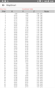
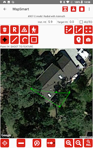
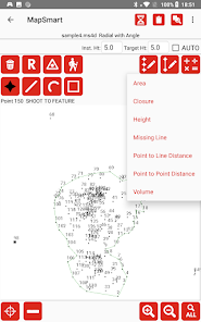
o Map with point, line, spline, and area feature types
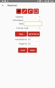
o Build custom notes, categories, and subcategories
o Assign height and missing line values to data points
o Include Photos with Measurement Data – including TruPoint 300 photos
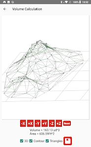
o Perform calculations (including volume) and get instant results
o Multiple report formats (DXF, CSV, GPX, PDF and more)
Requirements
Equipment: Laser Technology Incident Mapping Equipment with a TruPulse 360B, 360R, 200B, or 200X OR a TruPoint 300 or TruPoint 200h laser device.
Licensing: MapSmart software requires a license in order to be fully activated.
For a testimonial on the MapSmart solution for stockpile volume, see here: https://lasertech.com/customer-testimonial-lasersoft-mapsmart-simplifies-aggregate-assessments
Contact us for further information:
Laser Technology, Inc.
6912 S. Quentin St.
Centennial, CO 80112
303-649-1000
www.lasertech.com
Map, Measure & Position Smarter
MapSmart field data collection software is designed for anyone who needs to quickly and accurately map, measure, or position anything. It’s a simple yet powerful program that easily integrates with LTI laser devices and mapping accessories to turn a laser into a complete total station solution. This program was specifically designed to be easy to operate so more time can be spent mapping and collecting data rather than training. Choose to include GPS origin and offset coordinates with laser-based mapping or not. If you do, you only need to capture one perfect coordinate – all the others are mathematically calculated based on that position.
Experience the Freedom of BYOD
Mapping solutions by Laser Technology can get you from the field to the office in the least complex, most cost-effective, and most professional way vs. any other solution on the market. Assemble a hardware/software system for the way you work. Choose from a various laser options, include your high-accuracy Bluetooth GPS (or not), store your measurements on any Android device, and look at your surveys in any CAD or GIS visualization program.
Program Features
o Install, update and transfer data cable-free (no syncing necessary)
o Experience a simplified workflow optimized for a larger display
o Map with point, line, spline, and area feature types
o Build custom notes, categories, and subcategories
o Assign height and missing line values to data points
o Include Photos with Measurement Data – including TruPoint 300 photos
o Perform calculations (including volume) and get instant results
o Multiple report formats (DXF, CSV, GPX, PDF and more)
Requirements
Equipment: Laser Technology Incident Mapping Equipment with a TruPulse 360B, 360R, 200B, or 200X OR a TruPoint 300 or TruPoint 200h laser device.
Licensing: MapSmart software requires a license in order to be fully activated.
For a testimonial on the MapSmart solution for stockpile volume, see here: https://lasertech.com/customer-testimonial-lasersoft-mapsmart-simplifies-aggregate-assessments
Contact us for further information:
Laser Technology, Inc.
6912 S. Quentin St.
Centennial, CO 80112
303-649-1000
www.lasertech.com
Date de mise à jour
La sécurité, c'est d'abord comprendre comment les développeurs collectent et partagent vos données. Les pratiques concernant leur confidentialité et leur protection peuvent varier selon votre utilisation, votre région et votre âge. Le développeur a fourni ces informations et peut les modifier ultérieurement.

Aucune donnée partagée avec des tiers
En savoir plus sur la manière dont les développeurs déclarent le partage

Aucune donnée collectée
En savoir plus sur la manière dont les développeurs déclarent la collecte
Nouveautés
Maintenance release
Assistance de l'appli
phone
Numéro de téléphone
+13036491000
À propos du développeur
Laser Technology, Inc.
scolburn@lasertech.com
6912 S Quentin St
Centennial, CO 80112
United States
+1 303-418-2422


