
Poimapper Plus
10K+
Téléchargements

Tout public
info
À propos de l'application
Poimapper Plus changes the way organizations collect and analyze field data.
From industrial site mappings and inspections in Germany to monitoring the spread of Tuberculosis in Thailand and Market Research in India, Poimapper is helping organizations answer their most important questions around the world.
Analyze individual reports as well as large scale developments. Real-time field data leads to better decision making and collaboration.
- Easily allow field teams to collect data with their own language even in offline situations.
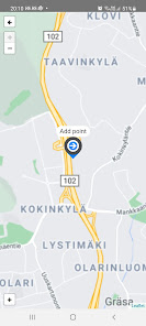
- Analyze & visualize data on maps, charts and sheets.
- Share existing data to field teams, after updates fetch it back to existing data systems.
- Interactive forms are designed to make the application easier and faster to use.
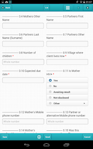
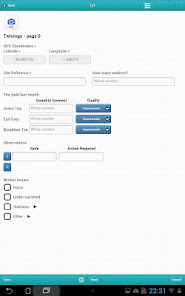
Poimapper Plus has a new fresh user interface and supports interactive forms for data collection. Interactive forms are our latest development to a faster, more reliable and more efficient working environment.
Interactive forms have features like skip logic and conditional questions that allow a set of questions to be viewed based on the response of previous questions. Calculated values mean that mobile form fields are automatically calculated based on values of previously answered questions.
If you have an older Android version than 4.0, please consider downloading the Poimapper application.
The mobile app is used in combination with the
www.poimapper.com web service.
Poimapper is an award winning solution used and supported across the
globe, with deployments in America, Asia, Africa and Europe.
Poimapper use cases:
• Building and construction site inspection work
• Environmental mapping and data collection
• Health care - survey, diagnose and patients treatment plans
• Market research
• Social research
• Registration of product sales
• Customer premises mapping
• Monitoring and evaluation of international development programs
• Reporting of traffic accidents
• Disaster risk assessment and post disaster relief mapping
• Water and sanitation mapping
• Registration of birth certificates
• Forestry inventory data collection
• Monitoring Agricultural development programs
• Educational surveys and school mapping
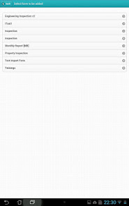
Key features:
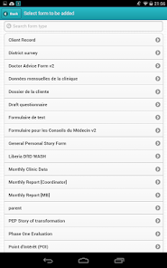
• Easy to use form builder
• Manage large amount of users
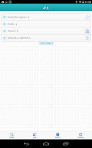
• Save, sync and share forms
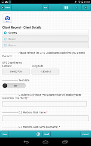
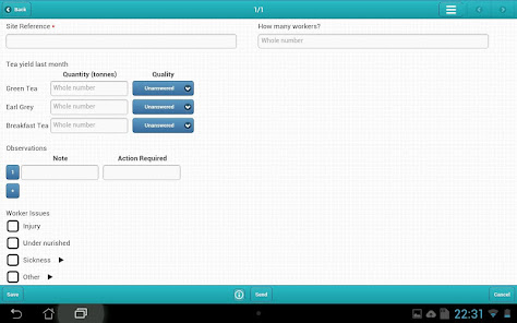
• Collect data including images, GPS, text, tables etc.
• Intelligent forms: skip logic, embedded logic statements
• Download and update existing enterprise data
• Visualize data on maps and tables
• Generate reports in grid, cross tabulated and various chart formats
• Export data and forms to Excel, Word, CSV, SPSS, KML
• Integrate with other systems using WebServices (JSON, XML, open API)
Poimapper is free for personal use. For organizational use, please contact us
on sales@poimapper.com for a free trial or upgrade the personal account.
Learn more: http://www.poimapper.com/
From industrial site mappings and inspections in Germany to monitoring the spread of Tuberculosis in Thailand and Market Research in India, Poimapper is helping organizations answer their most important questions around the world.
Analyze individual reports as well as large scale developments. Real-time field data leads to better decision making and collaboration.
- Easily allow field teams to collect data with their own language even in offline situations.
- Analyze & visualize data on maps, charts and sheets.
- Share existing data to field teams, after updates fetch it back to existing data systems.
- Interactive forms are designed to make the application easier and faster to use.
Poimapper Plus has a new fresh user interface and supports interactive forms for data collection. Interactive forms are our latest development to a faster, more reliable and more efficient working environment.
Interactive forms have features like skip logic and conditional questions that allow a set of questions to be viewed based on the response of previous questions. Calculated values mean that mobile form fields are automatically calculated based on values of previously answered questions.
If you have an older Android version than 4.0, please consider downloading the Poimapper application.
The mobile app is used in combination with the
www.poimapper.com web service.
Poimapper is an award winning solution used and supported across the
globe, with deployments in America, Asia, Africa and Europe.
Poimapper use cases:
• Building and construction site inspection work
• Environmental mapping and data collection
• Health care - survey, diagnose and patients treatment plans
• Market research
• Social research
• Registration of product sales
• Customer premises mapping
• Monitoring and evaluation of international development programs
• Reporting of traffic accidents
• Disaster risk assessment and post disaster relief mapping
• Water and sanitation mapping
• Registration of birth certificates
• Forestry inventory data collection
• Monitoring Agricultural development programs
• Educational surveys and school mapping
Key features:
• Easy to use form builder
• Manage large amount of users
• Save, sync and share forms
• Collect data including images, GPS, text, tables etc.
• Intelligent forms: skip logic, embedded logic statements
• Download and update existing enterprise data
• Visualize data on maps and tables
• Generate reports in grid, cross tabulated and various chart formats
• Export data and forms to Excel, Word, CSV, SPSS, KML
• Integrate with other systems using WebServices (JSON, XML, open API)
Poimapper is free for personal use. For organizational use, please contact us
on sales@poimapper.com for a free trial or upgrade the personal account.
Learn more: http://www.poimapper.com/
Date de mise à jour
La sécurité, c'est d'abord comprendre comment les développeurs collectent et partagent vos données. Les pratiques concernant leur confidentialité et leur protection peuvent varier selon votre utilisation, votre région et votre âge. Le développeur a fourni ces informations et peut les modifier ultérieurement.

Aucune donnée partagée avec des tiers
En savoir plus sur la manière dont les développeurs déclarent le partage

Cette appli peut recueillir ces types de données
Informations personnelles, Photos et vidéos et 4 autres

Les données sont chiffrées lors de leur transfert

Vous pouvez demander la suppression des données
Nouveautés
Fix to saving of subform data when using custom maps
Fix to debugupload
Fix to upload count indicator
Fix to debugupload
Fix to upload count indicator