
GPS Camera
Contient des annoncesAchats via l'appli
5K+
Téléchargements

Tout public
info


À propos de l'application
📍 GPS Camera – Geotag, Timestamp & Map Stamp Photo App
Capture every photo with exact location, date, and time automatically stamped on it!
GPS Camera is the ultimate app for adding GPS coordinates, map view, address, and timestamp directly to your photos. Perfect for travel memories, fieldwork, construction reports, or any professional documentation that requires proof of place and time.
🌍 Key Features
📸 Auto GPS Geotagging
Each photo is automatically tagged with precise latitude, longitude, altitude, and address. No more guessing where your photos were taken.
🕒 Timestamp & Date Stamp
Add accurate date, time, and timezone to your photos. Choose 12/24-hour format and customize the display style to match your project or report.
🗺️ Map Stamp Mode
Embed a live map (Google Map or Satellite view) into your picture with your exact location pin. Show the street name, city, and country right on your photo.
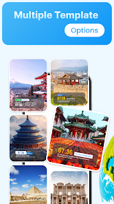
🎨 Customizable Templates
Choose from multiple templates like Classic, Modern, or Professional layouts.
Edit font, text color, alignment, transparency, and stamp position (top, bottom, left, right) to make your photos look perfect.
🌦️ Weather & Compass Info (Optional)
Show extra details such as weather, temperature, direction, and altitude — great for explorers, surveyors, and outdoor photographers.
📁 Smart Gallery Management
Easily browse, filter, and manage your stamped photos by location, date, or project. Instantly share via WhatsApp, Gmail, Instagram, or upload to cloud storage.
💼 Perfect For
Travelers & explorers – mark every destination with detailed map and time.
Construction, site inspection, real estate – prove photo authenticity with exact GPS stamp.
Fieldwork & surveys – record precise coordinates for reports and audits.
Agriculture & environment – track progress of crops, plants, and research zones.
Delivery & logistics teams – verify pickup or delivery locations.
⚙️ How To Use
Enable camera and location permissions.
Select your preferred stamp template and map style.
Capture your photo – the app automatically adds GPS, date, time, and map stamp.
View or share your geotagged photos instantly.
⭐ Why Choose GPS Camera?
Clean and professional GPS stamp for reports and fieldwork.
Fast and lightweight app – no unnecessary ads or heavy features.
100% accurate geotagging with real-time location.
Regular updates and new templates every month.
With GPS Camera, every photo becomes a verified record — complete with location, time, and map.
Whether for fun, travel, or work documentation, this is the best GPS map camera app to prove where and when your photos were taken.
Capture every photo with exact location, date, and time automatically stamped on it!
GPS Camera is the ultimate app for adding GPS coordinates, map view, address, and timestamp directly to your photos. Perfect for travel memories, fieldwork, construction reports, or any professional documentation that requires proof of place and time.
🌍 Key Features
📸 Auto GPS Geotagging
Each photo is automatically tagged with precise latitude, longitude, altitude, and address. No more guessing where your photos were taken.
🕒 Timestamp & Date Stamp
Add accurate date, time, and timezone to your photos. Choose 12/24-hour format and customize the display style to match your project or report.
🗺️ Map Stamp Mode
Embed a live map (Google Map or Satellite view) into your picture with your exact location pin. Show the street name, city, and country right on your photo.
🎨 Customizable Templates
Choose from multiple templates like Classic, Modern, or Professional layouts.
Edit font, text color, alignment, transparency, and stamp position (top, bottom, left, right) to make your photos look perfect.
🌦️ Weather & Compass Info (Optional)
Show extra details such as weather, temperature, direction, and altitude — great for explorers, surveyors, and outdoor photographers.
📁 Smart Gallery Management
Easily browse, filter, and manage your stamped photos by location, date, or project. Instantly share via WhatsApp, Gmail, Instagram, or upload to cloud storage.
💼 Perfect For
Travelers & explorers – mark every destination with detailed map and time.
Construction, site inspection, real estate – prove photo authenticity with exact GPS stamp.
Fieldwork & surveys – record precise coordinates for reports and audits.
Agriculture & environment – track progress of crops, plants, and research zones.
Delivery & logistics teams – verify pickup or delivery locations.
⚙️ How To Use
Enable camera and location permissions.
Select your preferred stamp template and map style.
Capture your photo – the app automatically adds GPS, date, time, and map stamp.
View or share your geotagged photos instantly.
⭐ Why Choose GPS Camera?
Clean and professional GPS stamp for reports and fieldwork.
Fast and lightweight app – no unnecessary ads or heavy features.
100% accurate geotagging with real-time location.
Regular updates and new templates every month.
With GPS Camera, every photo becomes a verified record — complete with location, time, and map.
Whether for fun, travel, or work documentation, this is the best GPS map camera app to prove where and when your photos were taken.
Date de mise à jour
La sécurité, c'est d'abord comprendre comment les développeurs collectent et partagent vos données. Les pratiques concernant leur confidentialité et leur protection peuvent varier selon votre utilisation, votre région et votre âge. Le développeur a fourni ces informations et peut les modifier ultérieurement.

Cette appli peut partager ces types de données avec des tiers
Position, Informations personnelles et 2 autres

Aucune donnée collectée
En savoir plus sur la manière dont les développeurs déclarent la collecte

Les données sont chiffrées lors de leur transfert
Nouveautés
Optimize Performance
Assistance de l'appli
À propos du développeur
Vu Ha Vi
trangvi9795@gmail.com
Căn hộ A-1706-A6 Chung cư Sun Square 21 Lê Đức Thọ, Mỹ Đình 2, Nam Từ Liêm
Hà Nội 10000
Vietnam


