
RipCharts
Achats via l'appli
4,5star
210 avis
10K+
Téléchargements

Tout public
info


À propos de l'application
Welcome to RipCharts - The industry leader in satellite fishing maps. This app is free to download for existing RipCharts Premium subscribers. If you are new to RipCharts, then we allow you to purchase a new RipCharts subscription via an In-App-Purchase. Please contact us if you have questions or would like a complementary demo. (http://www.ripcharts.com)
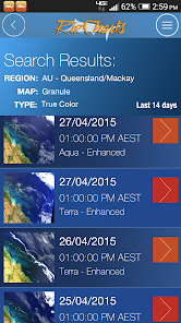
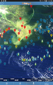
The RipCharts mobile app is a powerful tool that enables offshore fishermen to evaluate recent satellite imagery in order to determine favorable fishing conditions. Search for, view, and download maps of near-realtime satellite imagery onto your device to take with you offshore.
View the latest imagery datasets:
- Raw SST orbit scans
- Composite SST (1day,3day)
- Multi-Res/Cloud Free SST
- Sub-surface SST (0m, -25m, -50m, -100m)
- 5 day SST forecast models
- Chlorophyll
- Chlorophyll/Cloud mashups
- Chlorophyll composites
- True Color
- Altimetry
- Currents
- Salinity
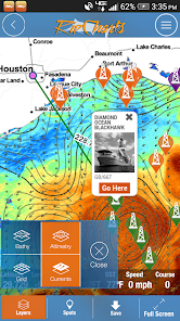
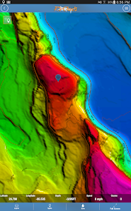
- Bathymetry
Map Features:
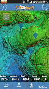
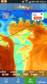
Use the multi-touch map to zoom, pan, view waypoints, and overlay additional data layers to gain insight into where the most favorable fishing zones are located.
Mapping Tools:
- Measure distances and headings between points
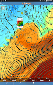
- Dynamically customize temp/color ranges on SST maps to identify subtle breaks <-- powerful feature!
- Overlay bathymetry, altimetry, currents, and Loran layers
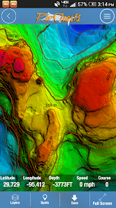
- Tap the map to receive point information (lat, lon, depth, SST)
- Popular waypoints and fishing hotspots come pre-loaded
- Manage your personal waypoints (add,edit,delete)
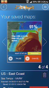
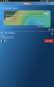
- Save imagery to your device for offline/offshore use
- Show your position and navigate on saved imagery using GPS satellites
- "Go Here" navigation with bearing, ETA, and speed displays
- Floater oil rig positions updated twice daily (Gulf of Mexico only)
The RipCharts mobile app is a powerful tool that enables offshore fishermen to evaluate recent satellite imagery in order to determine favorable fishing conditions. Search for, view, and download maps of near-realtime satellite imagery onto your device to take with you offshore.
View the latest imagery datasets:
- Raw SST orbit scans
- Composite SST (1day,3day)
- Multi-Res/Cloud Free SST
- Sub-surface SST (0m, -25m, -50m, -100m)
- 5 day SST forecast models
- Chlorophyll
- Chlorophyll/Cloud mashups
- Chlorophyll composites
- True Color
- Altimetry
- Currents
- Salinity
- Bathymetry
Map Features:
Use the multi-touch map to zoom, pan, view waypoints, and overlay additional data layers to gain insight into where the most favorable fishing zones are located.
Mapping Tools:
- Measure distances and headings between points
- Dynamically customize temp/color ranges on SST maps to identify subtle breaks <-- powerful feature!
- Overlay bathymetry, altimetry, currents, and Loran layers
- Tap the map to receive point information (lat, lon, depth, SST)
- Popular waypoints and fishing hotspots come pre-loaded
- Manage your personal waypoints (add,edit,delete)
- Save imagery to your device for offline/offshore use
- Show your position and navigate on saved imagery using GPS satellites
- "Go Here" navigation with bearing, ETA, and speed displays
- Floater oil rig positions updated twice daily (Gulf of Mexico only)
Date de mise à jour
La sécurité, c'est d'abord comprendre comment les développeurs collectent et partagent vos données. Les pratiques concernant leur confidentialité et leur protection peuvent varier selon votre utilisation, votre région et votre âge. Le développeur a fourni ces informations et peut les modifier ultérieurement.

Aucune donnée partagée avec des tiers
En savoir plus sur la manière dont les développeurs déclarent le partage

Cette appli peut recueillir ces types de données
Informations personnelles, Infos et performance des applis, Appareil ou autres ID

Les données ne sont pas chiffrées

Vous pouvez demander la suppression des données
Notes et avis
4,5
203 avis
Nouveautés
Updated Android Libraries
Assistance de l'appli
À propos du développeur
Ripcharts, LLC.
lan.lord+googleplay@gmail.com
7806 Wedgewood Ln
Houston, TX 77055-6847
United States
+1 832-264-1481


