

vTools Survey - GPS Mapping

10K+
Téléchargements

Tout public
info


À propos de l'application
Function of application:
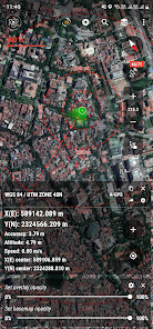
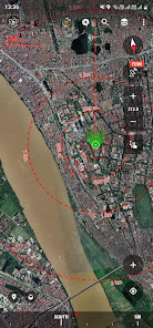
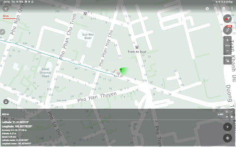
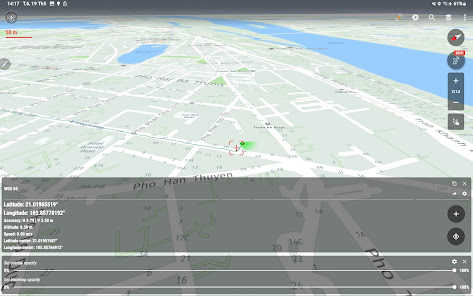
- Positioning, current position, practical view angle in the field. Help identify better directions.
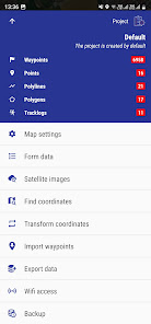
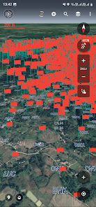
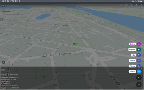
- Allows users to directly create objects (Points, Lines, Polygons, Coordinate Waypoints, Tracklog routes).
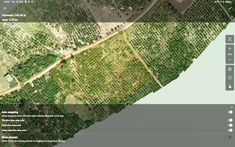
- Allows rapid measurement of the area and length of objects in the field.
- Users can simultaneously create Tracklog, Point, Line, and Polygon at the same time while moving. Tracklog mode allows running in the background.
- Support to save attribute information and images in the field.
- Users can define forms fields to collect. And share quickly to the whole group via QR code or export to file.
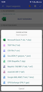
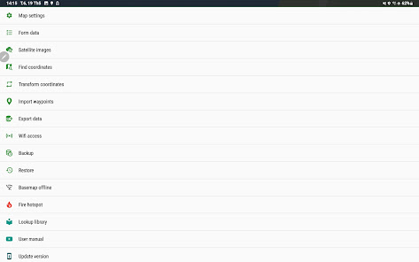
- Find for waypoint, enter a list of waypoints from data TEXT(*.txt), Excel (*.xls, *.xlsx), CSV (*.csv) Excel and convert point coordinates directly on the device.
- Allow to enter the list of points to check by hand (For example, it is necessary to check the location of the extract of the red book).
- Support directly opening common data such as Excel, GPS/GPX, KML/KMZ, GeoJSON, AutoCAD DXF, MicroStation DGN, ESRI Shapefile SHP, MapInfo TAB, gCadas GTP, GeoTIFF, JPG, PNG
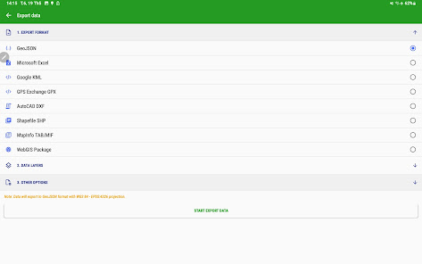
- Support export data to GPX, KML, GeoJSON, Excel, AutoCAD DXF, MapInfo TAB, Shapefile SHP format and share via Email, Drive, Zalo, Facebook etc.
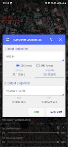
- Fully support the VN 2000 projection system of the local and nationwide of Vietnam.
- Support more than 5000 projection systems of other countries and territories in the world.
- Support for old projection systems like Hanoi 1972 (HN 72).
- Support numerical compass feature
- Support reading offline map data MBTiles and intelligent management of data layers.
- Support with simple MBTiles convert tool on Desktop, help to view properties directly from MBTiles layer.
- Support conversion of TCVN3, VNI encoding for Vietnamese font in viewing attribute information.
- Support field photography, save location, shooting direction on images and Exif information, GeoTag
- Allow users to download Google, MapBox, Bing, ESRI, OSM directly on the computer for offline use.
- Support web map service TMS and WMS.
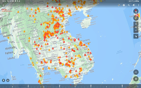
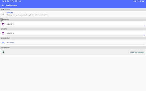
- The feature allows users to directly find and use Landsat 8 satellite image data (16-day update cycle) and Sentinel 2 (5-day update cycle) from the image database.
- Location view feature with 3D perspective with global elevation digital model.
If you need assistance please contact us at the following information:
Facebook: https://www.facebook.com/vToolsForMapInfo
Email: vtools.cskh@gmail.com
Phone (Zalo, WhatsApp, Viber, Telegram): (+84) 96 990 4596
Website: https://apps.vtools.xyz
Youtube: https://www.youtube.com/c/vTools/playlists
All Rights Reserved. Copyright © vTools Apps
- Positioning, current position, practical view angle in the field. Help identify better directions.
- Allows users to directly create objects (Points, Lines, Polygons, Coordinate Waypoints, Tracklog routes).
- Allows rapid measurement of the area and length of objects in the field.
- Users can simultaneously create Tracklog, Point, Line, and Polygon at the same time while moving. Tracklog mode allows running in the background.
- Support to save attribute information and images in the field.
- Users can define forms fields to collect. And share quickly to the whole group via QR code or export to file.
- Find for waypoint, enter a list of waypoints from data TEXT(*.txt), Excel (*.xls, *.xlsx), CSV (*.csv) Excel and convert point coordinates directly on the device.
- Allow to enter the list of points to check by hand (For example, it is necessary to check the location of the extract of the red book).
- Support directly opening common data such as Excel, GPS/GPX, KML/KMZ, GeoJSON, AutoCAD DXF, MicroStation DGN, ESRI Shapefile SHP, MapInfo TAB, gCadas GTP, GeoTIFF, JPG, PNG
- Support export data to GPX, KML, GeoJSON, Excel, AutoCAD DXF, MapInfo TAB, Shapefile SHP format and share via Email, Drive, Zalo, Facebook etc.
- Fully support the VN 2000 projection system of the local and nationwide of Vietnam.
- Support more than 5000 projection systems of other countries and territories in the world.
- Support for old projection systems like Hanoi 1972 (HN 72).
- Support numerical compass feature
- Support reading offline map data MBTiles and intelligent management of data layers.
- Support with simple MBTiles convert tool on Desktop, help to view properties directly from MBTiles layer.
- Support conversion of TCVN3, VNI encoding for Vietnamese font in viewing attribute information.
- Support field photography, save location, shooting direction on images and Exif information, GeoTag
- Allow users to download Google, MapBox, Bing, ESRI, OSM directly on the computer for offline use.
- Support web map service TMS and WMS.
- The feature allows users to directly find and use Landsat 8 satellite image data (16-day update cycle) and Sentinel 2 (5-day update cycle) from the image database.
- Location view feature with 3D perspective with global elevation digital model.
If you need assistance please contact us at the following information:
Facebook: https://www.facebook.com/vToolsForMapInfo
Email: vtools.cskh@gmail.com
Phone (Zalo, WhatsApp, Viber, Telegram): (+84) 96 990 4596
Website: https://apps.vtools.xyz
Youtube: https://www.youtube.com/c/vTools/playlists
All Rights Reserved. Copyright © vTools Apps
Date de mise à jour
La sécurité, c'est d'abord comprendre comment les développeurs collectent et partagent vos données. Les pratiques concernant leur confidentialité et leur protection peuvent varier selon votre utilisation, votre région et votre âge. Le développeur a fourni ces informations et peut les modifier ultérieurement.

Aucune donnée partagée avec des tiers
En savoir plus sur la manière dont les développeurs déclarent le partage

Aucune donnée collectée
En savoir plus sur la manière dont les développeurs déclarent la collecte

Les données sont chiffrées lors de leur transfert

Impossible de supprimer les données
Nouveautés
Updated version v8.0.1
- Support finding coordinates by Map Code.
- Optimize interface for large tablet screens.
- Fix some bugs.
- Support finding coordinates by Map Code.
- Optimize interface for large tablet screens.
- Fix some bugs.
Assistance de l'appli
phone
Numéro de téléphone
+84969904596
