Light pollution map

4,3star
75 avis
5K+
Téléchargements

Tout public
info


À propos de l'application
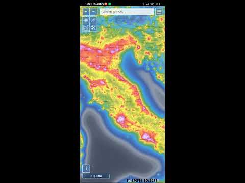
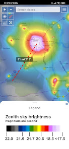
Light Pollution Map helps you easily find the darkest places nearby by combining high-resolution VIIRS satellite data with an interactive global map. Explore sky brightness, compare light pollution levels, and plan the perfect dark-sky trip or astrophotography session.
Whether you’re an astronomer, astrophotographer, stargazer, traveler, or simply curious about night sky quality, this map gives you access to the most accurate and up-to-date night-time light data available.
Key Features
• Interactive light pollution map with VIIRS (Black Marble 2.0) satellite radiance
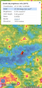
• Accurate sky brightness and dark sky map overlays (with color blind option)
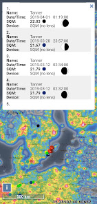
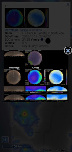
• Various mapping tools (point/area info, moon info, brightness simulation, find closest dark site, VIIRS country stats, adding your own SQM measurements, etc...)
• MPSAS (magnitude per square arc second) and Bortle scale estimation for easy comparison
• Switch between multiple light pollution datasets
• Global coverage with high detail
• Additional layers such as Aurora (with prediction), Clouds, user submitted SQM, etc...
• Offline-friendly — (World Atlas 2015 can be cached)
• Find dark sky locations for astronomy, camping & astrophotography
• Compare historical VIIRS data and track how light pollution changes
• Intuitive, fast map with smooth controls and fullscreen mode
• Clean, privacy-respecting design (no ads, no tracking)
VIIRS Satellite Data
The app uses NASA VIIRS Day/Night Band data — the same scientific dataset used by research institutions and environmental agencies for monitoring night-time brightness. This ensures maximum accuracy when evaluating artificial sky glow.
Find Dark Sky Locations
Quickly identify dark places for:
• Astrophotography
• Stargazing
• Camping trips
• Milky Way observations
• Meteor shower watching
• Light pollution research
• Aurora spotting
Why This App?
Light Pollution Map offers a clear, easy-to-read view of global sky brightness without ads or unnecessary features. It focuses purely on delivering the most accurate light pollution map possible — ideal for both hobbyists and professionals. No subscription or other hidden fees. Once you buy it, you have it for life with any update that follows.
You can explore the map on the official website to see how the data looks:
https://www.lightpollutionmap.info
The mobile app provides offline mode, GPS integration, and smoother performance.
Whether you’re an astronomer, astrophotographer, stargazer, traveler, or simply curious about night sky quality, this map gives you access to the most accurate and up-to-date night-time light data available.
Key Features
• Interactive light pollution map with VIIRS (Black Marble 2.0) satellite radiance
• Accurate sky brightness and dark sky map overlays (with color blind option)
• Various mapping tools (point/area info, moon info, brightness simulation, find closest dark site, VIIRS country stats, adding your own SQM measurements, etc...)
• MPSAS (magnitude per square arc second) and Bortle scale estimation for easy comparison
• Switch between multiple light pollution datasets
• Global coverage with high detail
• Additional layers such as Aurora (with prediction), Clouds, user submitted SQM, etc...
• Offline-friendly — (World Atlas 2015 can be cached)
• Find dark sky locations for astronomy, camping & astrophotography
• Compare historical VIIRS data and track how light pollution changes
• Intuitive, fast map with smooth controls and fullscreen mode
• Clean, privacy-respecting design (no ads, no tracking)
VIIRS Satellite Data
The app uses NASA VIIRS Day/Night Band data — the same scientific dataset used by research institutions and environmental agencies for monitoring night-time brightness. This ensures maximum accuracy when evaluating artificial sky glow.
Find Dark Sky Locations
Quickly identify dark places for:
• Astrophotography
• Stargazing
• Camping trips
• Milky Way observations
• Meteor shower watching
• Light pollution research
• Aurora spotting
Why This App?
Light Pollution Map offers a clear, easy-to-read view of global sky brightness without ads or unnecessary features. It focuses purely on delivering the most accurate light pollution map possible — ideal for both hobbyists and professionals. No subscription or other hidden fees. Once you buy it, you have it for life with any update that follows.
You can explore the map on the official website to see how the data looks:
https://www.lightpollutionmap.info
The mobile app provides offline mode, GPS integration, and smoother performance.
Date de mise à jour
La sécurité, c'est d'abord comprendre comment les développeurs collectent et partagent vos données. Les pratiques concernant leur confidentialité et leur protection peuvent varier selon votre utilisation, votre région et votre âge. Le développeur a fourni ces informations et peut les modifier ultérieurement.

Aucune donnée partagée avec des tiers
En savoir plus sur la manière dont les développeurs déclarent le partage

Aucune donnée collectée
En savoir plus sur la manière dont les développeurs déclarent la collecte
Notes et avis
4,3
72 avis
Nouveautés
- Aurora display fix
Assistance de l'appli
À propos du développeur
Deneb, Jurij Stare s.p.
starej@t-2.net
Adamiceva ulica 4
1000 LJUBLJANA
Slovenia
+386 41 367 875


