Norgeskart Outdoors
Achats via l'appli
100K+
Téléchargements

Tout public
info


À propos de l'application
Norgeskart Outdoors has everything you need for your outdoor activities. Be it hunting and fishing, hiking, cycling, skiing or boating. All functions and content can be made available even without mobile coverage.
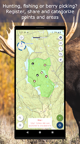
- Register, measure and categorise -
Register points of interest, routes, areas and record tracks. Organise the data by creating your own categories with colors and styles/icons for each category. If desired, your data can be written and read to/from GPX files or synchronised across devices and the map portal norgeskart.avinet.no. You can also easily share files with others from the lists of data in the app.
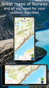
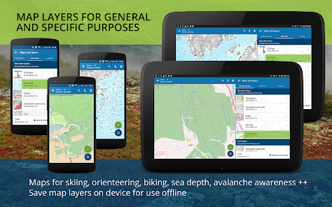
- Great outdoor maps and map layers -
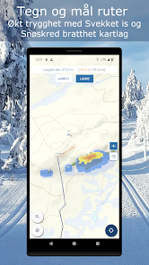
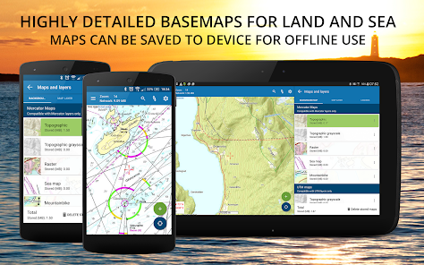
Choose from more than 40 maps and map layers. Beautiful maps of Norway from the Norwegian mapping authorities can be downloaded before you go on a trip for offline use. Many apps only let you turn on one layer at a time, here you can combine as many layers as you wish to create a complete overview of your surroundings. E.g. by turning on Pistes, Avalanche steepness and Weak ice layers.
- Own map and map layers -
Are you missing a map or map layer? The app now supports adding your own maps and layers from WMS, WMTS, XYZ and TMS services. A great source for additional maps and layers in Norway is the site geonorge.no. You can also try adding maps from other countries, but the app only support Mercator and UTM33 projections.
- TellTur -
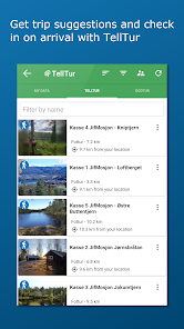
Plan your next trip with trip suggestions and descriptions from telltur.no. With TellTur you can use the app to register when you arrive at a tour destination and compete with others to visit the most places.
This app contains both free and paid content (see complete overview below). By paying for a subscription, you support the further development of the app and take full advantage of all the exciting things we have to offer.
Free content:
------------------
- Topo and nautical maps for Norway, Svalbard and Jan Mayen
- View place name and heigh/depth for cursor position
- Search for place names, addresses or coordinates
- Import and export of GPX files
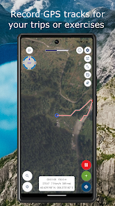
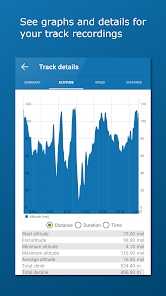
- Track recording with diagrams and details
- Create routes and POIs
- Compass
- Property borders
Pro subscription:
------------------
- Create and measure areas
- Create own categories
- Download Norwegian maps for offline use
- Topo map of Sweden (offline, but without download area function)
- Upload POIs, tracks and routes
- Synchronize your data across devices and with map portal
- Advanced properties layer (cadastre)
- Economic (N5 raster) map
- Historical map
- Trails
- Mountain bike routes
- Pistes for Alpine and Cross-country
- Avalanche awareness, steepness and incidents
- Weak ice
- Snow depth and skiing conditions
- Snowmobile tracks
- Sea depths and lake depths
- Anchorages
- Conservation areas
- Clay and radon
- Open air routes summer and winter
Pro+ subscription (199 NOK a year):
------------------
- All in Pro
- Orthophoto maps for Norway and Svalbard
- Add your own maps and layers
- (New) Bedrock map layer
- Periodic update of points from online KML files. Tested with TeleSpor.
- Register, measure and categorise -
Register points of interest, routes, areas and record tracks. Organise the data by creating your own categories with colors and styles/icons for each category. If desired, your data can be written and read to/from GPX files or synchronised across devices and the map portal norgeskart.avinet.no. You can also easily share files with others from the lists of data in the app.
- Great outdoor maps and map layers -
Choose from more than 40 maps and map layers. Beautiful maps of Norway from the Norwegian mapping authorities can be downloaded before you go on a trip for offline use. Many apps only let you turn on one layer at a time, here you can combine as many layers as you wish to create a complete overview of your surroundings. E.g. by turning on Pistes, Avalanche steepness and Weak ice layers.
- Own map and map layers -
Are you missing a map or map layer? The app now supports adding your own maps and layers from WMS, WMTS, XYZ and TMS services. A great source for additional maps and layers in Norway is the site geonorge.no. You can also try adding maps from other countries, but the app only support Mercator and UTM33 projections.
- TellTur -
Plan your next trip with trip suggestions and descriptions from telltur.no. With TellTur you can use the app to register when you arrive at a tour destination and compete with others to visit the most places.
This app contains both free and paid content (see complete overview below). By paying for a subscription, you support the further development of the app and take full advantage of all the exciting things we have to offer.
Free content:
------------------
- Topo and nautical maps for Norway, Svalbard and Jan Mayen
- View place name and heigh/depth for cursor position
- Search for place names, addresses or coordinates
- Import and export of GPX files
- Track recording with diagrams and details
- Create routes and POIs
- Compass
- Property borders
Pro subscription:
------------------
- Create and measure areas
- Create own categories
- Download Norwegian maps for offline use
- Topo map of Sweden (offline, but without download area function)
- Upload POIs, tracks and routes
- Synchronize your data across devices and with map portal
- Advanced properties layer (cadastre)
- Economic (N5 raster) map
- Historical map
- Trails
- Mountain bike routes
- Pistes for Alpine and Cross-country
- Avalanche awareness, steepness and incidents
- Weak ice
- Snow depth and skiing conditions
- Snowmobile tracks
- Sea depths and lake depths
- Anchorages
- Conservation areas
- Clay and radon
- Open air routes summer and winter
Pro+ subscription (199 NOK a year):
------------------
- All in Pro
- Orthophoto maps for Norway and Svalbard
- Add your own maps and layers
- (New) Bedrock map layer
- Periodic update of points from online KML files. Tested with TeleSpor.
Date de mise à jour
La sécurité, c'est d'abord comprendre comment les développeurs collectent et partagent vos données. Les pratiques concernant leur confidentialité et leur protection peuvent varier selon votre utilisation, votre région et votre âge. Le développeur a fourni ces informations et peut les modifier ultérieurement.

Aucune donnée partagée avec des tiers
En savoir plus sur la manière dont les développeurs déclarent le partage

Cette appli peut recueillir ces types de données
Position, Informations personnelles

Les données sont chiffrées lors de leur transfert

Vous pouvez demander la suppression des données
Nouveautés
3.24.4:
- Fixed innermost zoom level topo maps.
- Possible to zoom an extra level than available from service.
- Some minor fixes
3.24.x:
- New map services for sea map, topo maps and raster
- New and improved map selector
- Store and administrate named map areas
- Trails map layer
- Bedrock map layer
- Fixed innermost zoom level topo maps.
- Possible to zoom an extra level than available from service.
- Some minor fixes
3.24.x:
- New map services for sea map, topo maps and raster
- New and improved map selector
- Store and administrate named map areas
- Trails map layer
- Bedrock map layer


