
AgSAT

1ହ+
ଡାଉନଲୋଡଗୁଡ଼ିକ

ସମସ୍ତେ
info

ଏହି ଆପ୍ ବିଷୟରେ
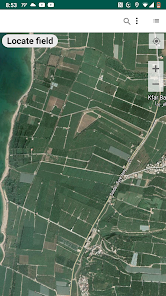
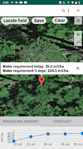
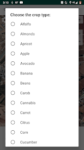
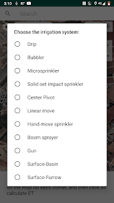
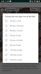
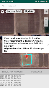
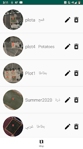
This application utilizes satellite imagery from NASA and the European Space Agency along with weather forecasts to calculate crop water requirements for irrigation management purposes. Users can delineate their fields on satellite imagery, select their crop type, irrigation system, and field pipe size, and the app will return daily water requirements and irrigation run times. Users can store their fields for later fetching of irrigation requirements in either m3/ha or m3 based on the delineated field area. Users can also opt to simply pin-point their fields, select their crop type and irrigation system, and the app will return required volume per ha. The app calculates water requirements on a daily basis and independent of water applications.
ଗତ ଅପଡେଟର ସମୟ
ଡେଭେଲପରମାନେ ଆପଣଙ୍କ ଡାଟାକୁ କିପରି ସଂଗ୍ରହ ଏବଂ ସେୟାର କରନ୍ତି ସେହି ଧାରଣା ସହିତ ସୁରକ୍ଷା ଆରମ୍ଭ ହୁଏ। ଆପଣଙ୍କ ବ୍ୟବହାର, ଅଞ୍ଚଳ ଏବଂ ବୟସ ଆଧାରରେ, ଡାଟା ଗୋପନୀୟତା ଓ ସୁରକ୍ଷା କାର୍ଯ୍ୟପଦ୍ଧତିଗୁଡ଼ିକ ଭିନ୍ନ ହୋଇପାରେ। ଡେଭେଲପର ଏହି ସୂଚନା ପ୍ରଦାନ କରିଛନ୍ତି ଏବଂ ସେ ସମୟାନୁସାରେ ଏହାକୁ ଅପଡେଟ କରିପାରନ୍ତି।

ତୃତୀୟ ପକ୍ଷଗୁଡ଼ିକ ସହ କୌଣସି ଡାଟା ସେୟାର କରାଯାଇନାହିଁ
ଡେଭେଲପରମାନେ କିପରି ସେୟାରିଂର ଘୋଷଣା କରନ୍ତି ସେ ବିଷୟରେ ଅଧିକ ଜାଣନ୍ତୁ

କୌଣସି ଡାଟା ସଂଗ୍ରହ କରାଯାଇନାହିଁ
ଡେଭେଲପରମାନେ କିପରି ସଂଗ୍ରହର ଘୋଷଣା କରନ୍ତି ସେ ବିଷୟରେ ଅଧିକ ଜାଣନ୍ତୁ
ଆପ ସପୋର୍ଟ
phone
ଫୋନ୍ ନମ୍ଵର୍
+9613722961