Trafmon in Maryland
ବିଜ୍ଞାପନ ଅନ୍ତର୍ଭୂକ୍ତ
3.8star
14ଟି ସମୀକ୍ଷା
1ହ+
ଡାଉନଲୋଡଗୁଡ଼ିକ

ସମସ୍ତେ
info

ଏହି ଆପ୍ ବିଷୟରେ
** Disclaimer: This app does not represent any government entity. **
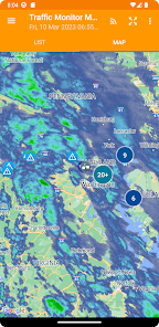
Note: Traffic data source for the app comes from the Maryland Department of Transportation's Coordinated Highways Action Response Team . For more detailed information about the traffic data, visit https://chart.maryland.gov/DataFeeds/GetDataFeeds. (Please note that the website is only accessible from within the USA). The weather imagery data comes from the National Oceanic and Atmospheric Administration (NOAA). The imagery source website is https://nowcoast.noaa.gov/.
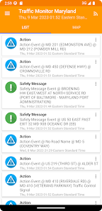
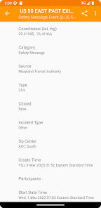
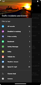
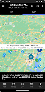
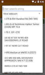
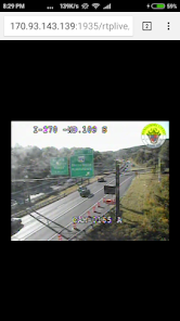
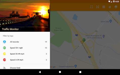
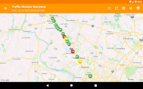
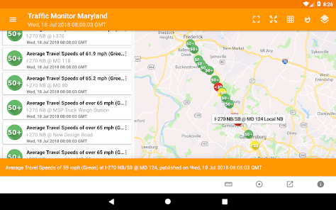
Users can monitor information about traffic incidents and events, active road closures, average travel speeds on Maryland's highway system using this app. The traffic information can be viewed as a text list, or on a map as icons.
Note: Traffic data source for the app comes from the Maryland Department of Transportation's Coordinated Highways Action Response Team . For more detailed information about the traffic data, visit https://chart.maryland.gov/DataFeeds/GetDataFeeds. (Please note that the website is only accessible from within the USA). The weather imagery data comes from the National Oceanic and Atmospheric Administration (NOAA). The imagery source website is https://nowcoast.noaa.gov/.
Users can monitor information about traffic incidents and events, active road closures, average travel speeds on Maryland's highway system using this app. The traffic information can be viewed as a text list, or on a map as icons.
ଗତ ଅପଡେଟର ସମୟ
ଡେଭେଲପରମାନେ ଆପଣଙ୍କ ଡାଟାକୁ କିପରି ସଂଗ୍ରହ ଏବଂ ସେୟାର କରନ୍ତି ସେହି ଧାରଣା ସହିତ ସୁରକ୍ଷା ଆରମ୍ଭ ହୁଏ। ଆପଣଙ୍କ ବ୍ୟବହାର, ଅଞ୍ଚଳ ଏବଂ ବୟସ ଆଧାରରେ, ଡାଟା ଗୋପନୀୟତା ଓ ସୁରକ୍ଷା କାର୍ଯ୍ୟପଦ୍ଧତିଗୁଡ଼ିକ ଭିନ୍ନ ହୋଇପାରେ। ଡେଭେଲପର ଏହି ସୂଚନା ପ୍ରଦାନ କରିଛନ୍ତି ଏବଂ ସେ ସମୟାନୁସାରେ ଏହାକୁ ଅପଡେଟ କରିପାରନ୍ତି।

ତୃତୀୟ ପକ୍ଷଗୁଡ଼ିକ ସହ କୌଣସି ଡାଟା ସେୟାର କରାଯାଇନାହିଁ
ଡେଭେଲପରମାନେ କିପରି ସେୟାରିଂର ଘୋଷଣା କରନ୍ତି ସେ ବିଷୟରେ ଅଧିକ ଜାଣନ୍ତୁ

କୌଣସି ଡାଟା ସଂଗ୍ରହ କରାଯାଇନାହିଁ
ଡେଭେଲପରମାନେ କିପରି ସଂଗ୍ରହର ଘୋଷଣା କରନ୍ତି ସେ ବିଷୟରେ ଅଧିକ ଜାଣନ୍ତୁ

ଟ୍ରାଞ୍ଜିଟ ସମୟରେ ଡାଟା ଏନକ୍ରିପ୍ଟ କରାଯାଇଥାଏ

ଡାଟା ଡିଲିଟ କରାଯାଇପାରିବ ନାହିଁ
ମୂଲ୍ୟାଙ୍କନ ଓ ସମୀକ୍ଷା
3.7
13ଟି ସମୀକ୍ଷା
ନୂଆ କଣ ଅଛି
Upgrade to Android API 34.
Upgrade to Maps 18.2.0.
Fix feed downloading.
Upgrade to Maps 18.2.0.
Fix feed downloading.


