
Ignis Pixhawk
100+
ଡାଉନଲୋଡ

ସମସ୍ତେ
info


ଏହି ଆପ୍ ବିଷୟରେ
Enhance your missions with Pixhawk drones. Features:
- Offline satellite and elevation maps
- Terrain-aware waypoint missions
- Mapping mission planning and execution
- Import PDF and KMZ map overlays
- Connect to your drone's radio via the internet, USB, or Bluetooth
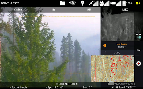
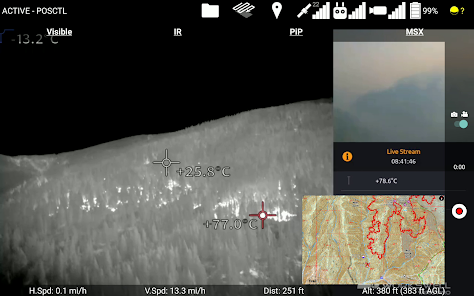
- Live video feed via the RTSP internet protocol
- Control Gremsy's Pixy U gimbal, and Workswell's Wiris Pro EO/IR camera
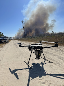
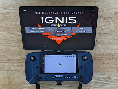
- Control Drone Amplified's Ignis payload to conduct prescribed burns
- Mark locations of interest and features and save them as a KMZ file
- View nearby aircraft via ADSB
- Supports Px4 and Arducopter flight controller firmwares
- Offline satellite and elevation maps
- Terrain-aware waypoint missions
- Mapping mission planning and execution
- Import PDF and KMZ map overlays
- Connect to your drone's radio via the internet, USB, or Bluetooth
- Live video feed via the RTSP internet protocol
- Control Gremsy's Pixy U gimbal, and Workswell's Wiris Pro EO/IR camera
- Control Drone Amplified's Ignis payload to conduct prescribed burns
- Mark locations of interest and features and save them as a KMZ file
- View nearby aircraft via ADSB
- Supports Px4 and Arducopter flight controller firmwares
ଗତ ଅପଡେଟର ସମୟ
ଡେଭେଲପରମାନେ ଆପଣଙ୍କ ଡାଟାକୁ କିପରି ସଂଗ୍ରହ ଏବଂ ସେୟାର କରନ୍ତି ସେହି ଧାରଣା ସହିତ ସୁରକ୍ଷା ଆରମ୍ଭ ହୁଏ। ଆପଣଙ୍କ ବ୍ୟବହାର, ଅଞ୍ଚଳ ଏବଂ ବୟସ ଆଧାରରେ, ଡାଟା ଗୋପନୀୟତା ଓ ସୁରକ୍ଷା ପ୍ରାକ୍ଟିସ ଭିନ୍ନ ହୋଇପାରେ। ଡେଭେଲପର ଏହି ସୂଚନା ପ୍ରଦାନ କରିଛନ୍ତି ଏବଂ ସେ ସମୟାନୁସାରେ ଏହାକୁ ଅପଡେଟ କରିପାରନ୍ତି।

ତୃତୀୟ ପକ୍ଷଗୁଡ଼ିକ ସହ କୌଣସି ଡାଟା ସେୟାର କରାଯାଇନାହିଁ
ଡେଭେଲପରମାନେ କିପରି ସେୟାରିଂର ଘୋଷଣା କରନ୍ତି ସେ ବିଷୟରେ ଅଧିକ ଜାଣନ୍ତୁ

କୌଣସି ଡାଟା ସଂଗ୍ରହ କରାଯାଇନାହିଁ
ଡେଭେଲପରମାନେ କିପରି ସଂଗ୍ରହର ଘୋଷଣା କରନ୍ତି ସେ ବିଷୟରେ ଅଧିକ ଜାଣନ୍ତୁ
ନୂଆ କଣ ଅଛି
Fixed a potential crash on startup when you have missions older than 51 days.
ଆପ ସପୋର୍ଟ
ଡେଭେଲପରଙ୍କ ବିଷୟରେ
Drone Amplified, Inc.
appdev@droneamplified.com
1811 S Pershing Rd
Lincoln, NE 68502
United States
+1 402-413-0686