AndMeasure (Area & Distance)

4.2star
2.8ହଟି ସମୀକ୍ଷା
500ହ+
ଡାଉନଲୋଡଗୁଡ଼ିକ

ସମସ୍ତେ
info


ଏହି ଆପ୍ ବିଷୟରେ
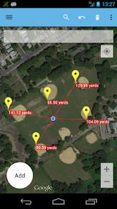
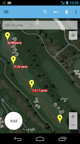
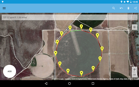
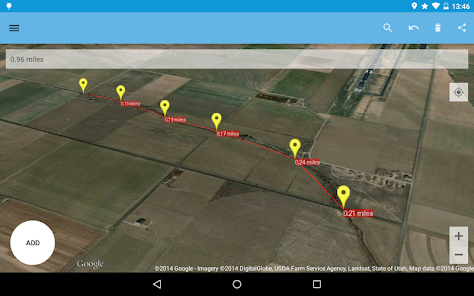
The AndMeasure tool allows you to measure distances and calculate area between points on a map.
The tool has virtually unlimited applications. Use it PROFESSIONALLY for measuring distances and areas in landscaping, lawn care, water line measuring, paving and fencing. Use it in farming, agriculture and forestry to measure your fields and forests. Realtor's can use it for showing clients distances to certain landmarks.
For RECREATIONAL use, it can be used in measuring off-road routes, plotting running courses, water trips, range estimation at the shooting/driving range. Use it in Golf for getting real-time distance to the green.
★★★ Featured on AgWeb.com powered by Farm Journal ★★★
"This app could be an easy way for farmers to measure new fields." March 2012
Features:
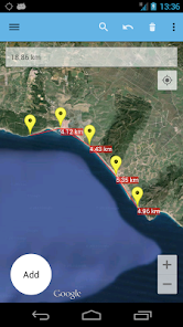
● Use it as a ruler on a map to calculate the distance between multiple points
● Calculate areas in acres, sq miles, sq feet, m2, km2, Hectare, Ares
● Measure the distance to your location from multiple points in real-time using the "continuous mode" feature
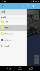
● Switch between Satellite, Hybrid, Terrain and normal map mode
● Find your current location via GPS or Network
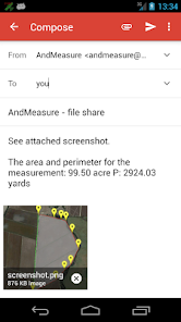
● Share measurement and screenshot, CSV and KML via email and Google Drive
● Add markers to the map either via tap or by dragging from the "add button" to get super accuracy
● Move markers around to get precise measurement
Languages: English (write an email if you want to help with other translations)
Get it at:
https://play.google.com/store/apps/details?id=com.megelc.andmeasure
Facebook:
http://www.facebook.com/andmeasure
Privacy Policy:
AndMeasure does not store any personal information at all :-)
The tool has virtually unlimited applications. Use it PROFESSIONALLY for measuring distances and areas in landscaping, lawn care, water line measuring, paving and fencing. Use it in farming, agriculture and forestry to measure your fields and forests. Realtor's can use it for showing clients distances to certain landmarks.
For RECREATIONAL use, it can be used in measuring off-road routes, plotting running courses, water trips, range estimation at the shooting/driving range. Use it in Golf for getting real-time distance to the green.
★★★ Featured on AgWeb.com powered by Farm Journal ★★★
"This app could be an easy way for farmers to measure new fields." March 2012
Features:
● Use it as a ruler on a map to calculate the distance between multiple points
● Calculate areas in acres, sq miles, sq feet, m2, km2, Hectare, Ares
● Measure the distance to your location from multiple points in real-time using the "continuous mode" feature
● Switch between Satellite, Hybrid, Terrain and normal map mode
● Find your current location via GPS or Network
● Share measurement and screenshot, CSV and KML via email and Google Drive
● Add markers to the map either via tap or by dragging from the "add button" to get super accuracy
● Move markers around to get precise measurement
Languages: English (write an email if you want to help with other translations)
Get it at:
https://play.google.com/store/apps/details?id=com.megelc.andmeasure
Facebook:
http://www.facebook.com/andmeasure
Privacy Policy:
AndMeasure does not store any personal information at all :-)
ଗତ ଅପଡେଟର ସମୟ
ଡେଭେଲପରମାନେ ଆପଣଙ୍କ ଡାଟାକୁ କିପରି ସଂଗ୍ରହ ଏବଂ ସେୟାର କରନ୍ତି ସେହି ଧାରଣା ସହିତ ସୁରକ୍ଷା ଆରମ୍ଭ ହୁଏ। ଆପଣଙ୍କ ବ୍ୟବହାର, ଅଞ୍ଚଳ ଏବଂ ବୟସ ଆଧାରରେ, ଡାଟା ଗୋପନୀୟତା ଓ ସୁରକ୍ଷା କାର୍ଯ୍ୟପଦ୍ଧତିଗୁଡ଼ିକ ଭିନ୍ନ ହୋଇପାରେ। ଡେଭେଲପର ଏହି ସୂଚନା ପ୍ରଦାନ କରିଛନ୍ତି ଏବଂ ସେ ସମୟାନୁସାରେ ଏହାକୁ ଅପଡେଟ କରିପାରନ୍ତି।

ତୃତୀୟ ପକ୍ଷଗୁଡ଼ିକ ସହ କୌଣସି ଡାଟା ସେୟାର କରାଯାଇନାହିଁ
ଡେଭେଲପରମାନେ କିପରି ସେୟାରିଂର ଘୋଷଣା କରନ୍ତି ସେ ବିଷୟରେ ଅଧିକ ଜାଣନ୍ତୁ

କୌଣସି ଡାଟା ସଂଗ୍ରହ କରାଯାଇନାହିଁ
ଡେଭେଲପରମାନେ କିପରି ସଂଗ୍ରହର ଘୋଷଣା କରନ୍ତି ସେ ବିଷୟରେ ଅଧିକ ଜାଣନ୍ତୁ
ମୂଲ୍ୟାଙ୍କନ ଓ ସମୀକ୍ଷା
4.3
2.63ହଟି ସମୀକ୍ଷା
ନୂଆ କଣ ଅଛି
Minor improvements and updates
ଆପ ସପୋର୍ଟ
ଡେଭେଲପରଙ୍କ ବିଷୟରେ
Mikkel Lønnerup Christensen
andmeasure@gmail.com
Aladdinvej 27A
9260 Gistrup
Denmark
undefined