
Estonian Drone Map
ସରକାର
info
500+
ଡାଉନଲୋଡ

ସମସ୍ତେ
info

ଏହି ଆପ୍ ବିଷୟରେ
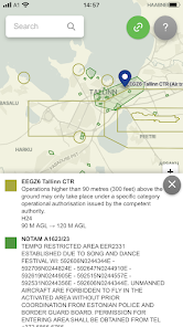
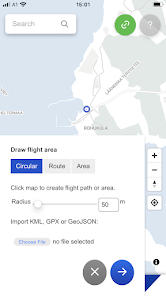
Estonian Drone Map is the official UTM solution from Estonian Air Navigation Services. The application allows you to see the rules for flying in Estonia, plan your flights and coordinate them with the air navigation service provider, if necessary.
The current app version:
• Displays all the temporary and permanent restriction areas, including UAS geozones and NOTAM's
• Allows the pilot to plan their flights and submit flight plans (not mandatory for open category flights)
• Ask the ANSP for mandatory take-off clearance near helicopter pads and for specific category flights
ଗତ ଅପଡେଟର ସମୟ
ଡେଭେଲପରମାନେ ଆପଣଙ୍କ ଡାଟାକୁ କିପରି ସଂଗ୍ରହ ଏବଂ ସେୟାର କରନ୍ତି ସେହି ଧାରଣା ସହିତ ସୁରକ୍ଷା ଆରମ୍ଭ ହୁଏ। ଆପଣଙ୍କ ବ୍ୟବହାର, ଅଞ୍ଚଳ ଏବଂ ବୟସ ଆଧାରରେ, ଡାଟା ଗୋପନୀୟତା ଓ ସୁରକ୍ଷା ପ୍ରାକ୍ଟିସ ଭିନ୍ନ ହୋଇପାରେ। ଡେଭେଲପର ଏହି ସୂଚନା ପ୍ରଦାନ କରିଛନ୍ତି ଏବଂ ସେ ସମୟାନୁସାରେ ଏହାକୁ ଅପଡେଟ କରିପାରନ୍ତି।

ତୃତୀୟ ପକ୍ଷଗୁଡ଼ିକ ସହ କୌଣସି ଡାଟା ସେୟାର କରାଯାଇନାହିଁ
ଡେଭେଲପରମାନେ କିପରି ସେୟାରିଂର ଘୋଷଣା କରନ୍ତି ସେ ବିଷୟରେ ଅଧିକ ଜାଣନ୍ତୁ

ଏହି ଆପ ଏହି ପ୍ରକାର ଡାଟା ସଂଗ୍ରହ କରିପାରେ
ବ୍ୟକ୍ତିଗତ ସୂଚନା, ମେସେଜଗୁଡ଼ିକ ଏବଂ ଅନ୍ୟ 2ଟି

ଟ୍ରାଞ୍ଜିଟ ସମୟରେ ଡାଟା ଏନକ୍ରିପ୍ଟ କରାଯାଇଥାଏ

ଡାଟା ଡିଲିଟ କରିଦିଆଯାଉ ବୋଲି ଆପଣ ଅନୁରୋଧ କରିପାରିବେ
ନୂଆ କଣ ଅଛି
- Weather warnings and forecast in selected language
- Improved the search function in the Operator Map
- Improved zone display for future flight plans
- Improved drone name display
- Improved the search function in the Operator Map
- Improved zone display for future flight plans
- Improved drone name display
ଆପ ସପୋର୍ଟ
ଡେଭେଲପରଙ୍କ ବିଷୟରେ
Lennuliiklusteeninduse Aktsiaselts
reigo.podar@eans.ee
Kanali poik 3/1
Rae kula
10112
Estonia
+372 5566 1693