LINZ Geodetic Marks
5ହ+
ଡାଉନଲୋଡଗୁଡ଼ିକ

ସମସ୍ତେ
info
ଏହି ଆପ୍ ବିଷୟରେ
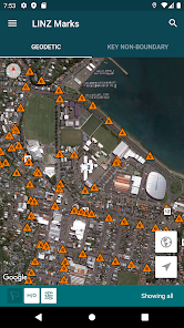
Use the app to navigate to New Zealand's geodetic marks. You can also submit updated mark photos and other information to LINZ.
The app also includes important non-geodetic marks that may need to be protected when road and footpath works, trenching and other similar activities are being carried out.
Key features:
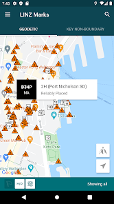
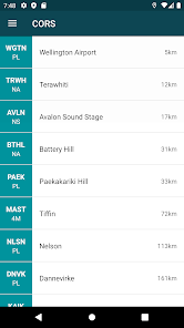
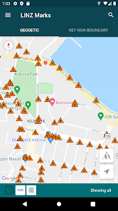
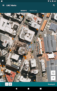
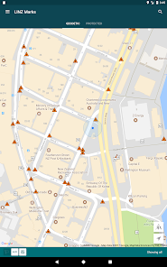
- Find geodetic marks and other key non-boundary marks
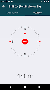
- Navigate to marks using compass and distance, or Google Maps
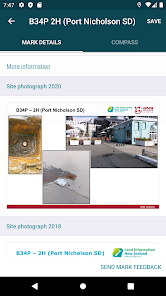
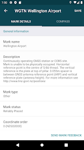
- Access mark details, access diagrams and photos
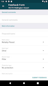
- Submit updated mark details and photos to LINZ
- Advise LINZ of mark maintenance issues
- Create and save mark groups
- Identify nearby PositioNZ GNSS stations
- Toggle display between horizontal and vertical marks
- Filter displayed marks by coordinate order and beacon type
You can find out more about New Zealand's geodetic marks at http://www.linz.govt.nz/gdb
The app also includes important non-geodetic marks that may need to be protected when road and footpath works, trenching and other similar activities are being carried out.
Key features:
- Find geodetic marks and other key non-boundary marks
- Navigate to marks using compass and distance, or Google Maps
- Access mark details, access diagrams and photos
- Submit updated mark details and photos to LINZ
- Advise LINZ of mark maintenance issues
- Create and save mark groups
- Identify nearby PositioNZ GNSS stations
- Toggle display between horizontal and vertical marks
- Filter displayed marks by coordinate order and beacon type
You can find out more about New Zealand's geodetic marks at http://www.linz.govt.nz/gdb
ଗତ ଅପଡେଟର ସମୟ
ଡେଭେଲପରମାନେ ଆପଣଙ୍କ ଡାଟାକୁ କିପରି ସଂଗ୍ରହ ଏବଂ ସେୟାର କରନ୍ତି ସେହି ଧାରଣା ସହିତ ସୁରକ୍ଷା ଆରମ୍ଭ ହୁଏ। ଆପଣଙ୍କ ବ୍ୟବହାର, ଅଞ୍ଚଳ ଏବଂ ବୟସ ଆଧାରରେ, ଡାଟା ଗୋପନୀୟତା ଓ ସୁରକ୍ଷା କାର୍ଯ୍ୟପଦ୍ଧତିଗୁଡ଼ିକ ଭିନ୍ନ ହୋଇପାରେ। ଡେଭେଲପର ଏହି ସୂଚନା ପ୍ରଦାନ କରିଛନ୍ତି ଏବଂ ସେ ସମୟାନୁସାରେ ଏହାକୁ ଅପଡେଟ କରିପାରନ୍ତି।

ତୃତୀୟ ପକ୍ଷଗୁଡ଼ିକ ସହ କୌଣସି ଡାଟା ସେୟାର କରାଯାଇନାହିଁ
ଡେଭେଲପରମାନେ କିପରି ସେୟାରିଂର ଘୋଷଣା କରନ୍ତି ସେ ବିଷୟରେ ଅଧିକ ଜାଣନ୍ତୁ

ଏହି ଆପ ଏଇ ଡାଟା ପ୍ରକାରଗୁଡ଼ିକ ସଂଗ୍ରହ କରିପାରେ
ବ୍ୟକ୍ତିଗତ ସୂଚନା, ଫଟୋ ଏବଂ ଭିଡିଓଗୁଡ଼ିକ ଏବଂ ଅନ୍ୟ 2ଟି

ଟ୍ରାଞ୍ଜିଟ ସମୟରେ ଡାଟା ଏନକ୍ରିପ୍ଟ କରାଯାଇଥାଏ

ଡାଟା ଡିଲିଟ କରିଦିଆଯାଉ ବୋଲି ଆପଣ ଅନୁରୋଧ କରିପାରିବେ