Night Earth
มีโฆษณา
3.9star
604 รีวิว
100K+
ดาวน์โหลด

สำหรับทุกคน
info


เกี่ยวกับแอปนี้
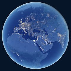
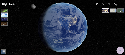
แผนที่ Night Earth เป็นเครื่องมืออันน่าทึ่งที่ช่วยให้เราสำรวจและทำความเข้าใจผลกระทบของมลภาวะทางแสงที่มีต่อโลกของเรา ให้มุมมองที่น่าทึ่งของพื้นผิวโลก แสดงแสงที่มองเห็นได้ในเวลากลางคืน และเน้นบริเวณที่สว่างที่สุดและเป็นเมืองมากที่สุด
คุณสมบัติ:
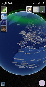
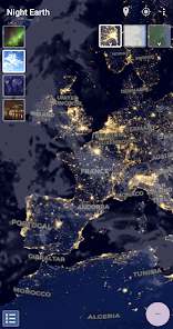
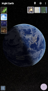
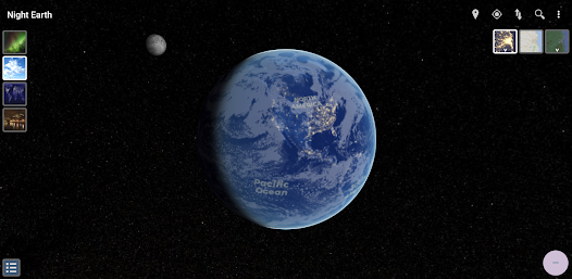
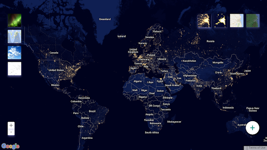
• ดูโลกในเวลากลางคืนจากอวกาศ
• การสังเกตแสงที่มนุษย์สร้างขึ้นจากอวกาศและมลภาวะทางแสงที่เกิดขึ้น
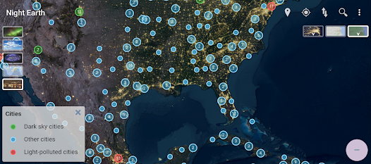
• ตำแหน่งจุดที่มีมลภาวะทางแสงน้อย เพื่อการสังเกตดวงดาวที่ดีขึ้น
• มุมมอง 3 มิติพร้อมเอฟเฟ็กต์บรรยากาศโดยละเอียด เพื่อทัศนียภาพที่สวยงาม
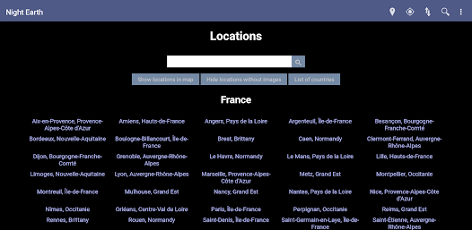
• ค้นหาตำแหน่งใดๆ หรือบอกให้แอปพลิเคชันโฟกัสที่ตำแหน่งปัจจุบันของคุณ
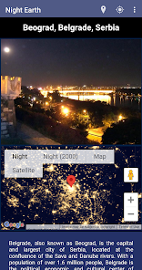
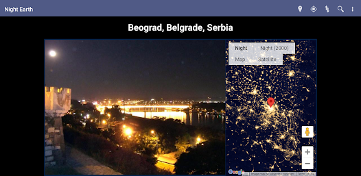
• ซ้อนทับภาพกลางคืนลงบนดาวเทียมหรือแผนที่ถนน
• เปรียบเทียบภาพถ่ายกลางคืนที่ NASA ถ่ายในปีต่างๆ
• ติดตามว่าส่วนใดของโลกขณะนี้เป็นเวลากลางวันหรือกลางคืน
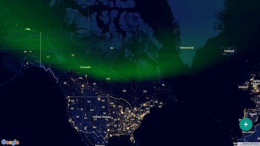
• การแสดงภาพแสงเหนือและแสงใต้แบบเรียลไทม์ (แสงเหนือและแสงใต้)
• การครอบคลุมเมฆตามเวลาจริงทั่วโลก เพื่อตรวจสอบตำแหน่งที่สามารถสังเกตดวงดาวหรือแสงออโรราได้ในขณะนี้
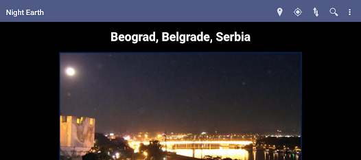
• ภาพกลางคืนที่มีรายละเอียดซึ่งถ่ายโดยนักบินอวกาศบนสถานีอวกาศนานาชาติและแหล่งข้อมูลอื่นๆ
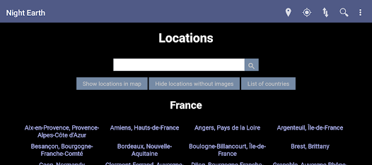
• ข้อมูลมลพิษทางแสงในสถานที่ต่างๆ กว่า 5,000 แห่งใน 170 ประเทศ สาเหตุ และมาตรการที่ดำเนินการเพื่อลดมลพิษ
มีแผนที่กลางคืนสองเวอร์ชันที่ NASA บันทึกไว้ในปีที่ต่างกัน แผนที่รายละเอียดเหล่านี้คิดเป็น 437.495 ภาพที่โฮสต์ในเว็บไซต์ Night Earth (http://www.nightearth.com)
รองรับอุปกรณ์ที่ใช้ Android 5.1 เป็นต้นไป และ Android TV
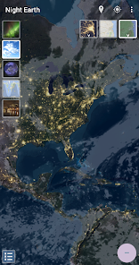
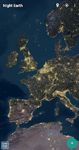
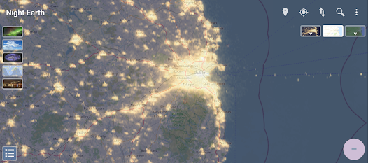
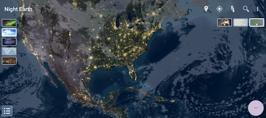
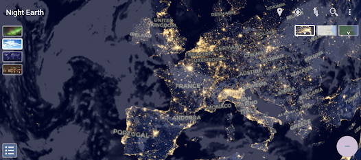
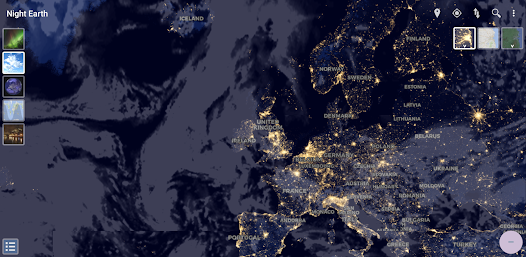
แผนที่ Night Earth แสดงความแตกต่างที่ชัดเจนของการขยายตัวของเมืองและความหนาแน่นของประชากรทั่วโลก ซึ่งแสดงให้เห็นว่าเมืองมีแนวโน้มที่จะกระจุกตัวตามแนวชายฝั่งและเครือข่ายการขนส่งอย่างไร
คุณสมบัติเด่นอย่างหนึ่งของแผนที่คือความสามารถในการเน้นความแตกต่างระหว่างความสว่างและความหนาแน่นของประชากร แม้ว่าบางพื้นที่อาจดูสว่างที่สุด แต่ก็อาจไม่จำเป็นต้องเป็นเขตที่มีประชากรหนาแน่นที่สุด แผนที่แสดงภาพปรากฏการณ์นี้โดยนำเสนอข้อมูลเชิงลึกเกี่ยวกับรูปแบบการตั้งถิ่นฐานและการพัฒนาของมนุษย์
ยิ่งไปกว่านั้น แผนที่ Night Earth ยังเปิดเผยพื้นที่อันกว้างใหญ่ของโลกของเราที่ยังคงมีประชากรเบาบางและไม่มีแสงสว่าง แอนตาร์กติกากลายเป็นพื้นที่กว้างใหญ่ที่มืดสนิท เตือนเราถึงความโดดเดี่ยวและความงามของโลกอื่น ในทำนองเดียวกัน ป่าภายในของแอฟริกาและอเมริกาใต้ ทะเลทรายในส่วนต่างๆ ของโลก และป่าทางเหนืออันห่างไกลของแคนาดาและรัสเซีย ล้วนมีแสงสว่างจำกัด สะท้อนถึงความท้าทายที่ผู้คนในภูมิภาคเหล่านี้ต้องเผชิญเมื่อต้องเข้าถึงไฟฟ้าและโครงสร้างพื้นฐาน .
นอกจากคุณค่าทางข้อมูลแล้ว แผนที่ Night Earth ยังมีความสวยงาม ทำให้เราสามารถชื่นชมความงามของโลกจากมุมมองที่ไม่เหมือนใคร นำเสนอมุมมองที่น่าดึงดูดใจเกี่ยวกับมลภาวะทางแสงของโลก และทำหน้าที่เป็นเครื่องเตือนใจถึงความสัมพันธ์ที่ซับซ้อนระหว่างกิจกรรมของมนุษย์ การกระจายตัวของประชากร และสิ่งแวดล้อมทางธรรมชาติ
-------------------------------------------------- --------------
นี่เป็นเวอร์ชันฟรีของแอปพลิเคชัน สำหรับเวอร์ชันที่ไม่มีโฆษณา คุณสามารถดูแอป "Night Earth plus" ที่แยกต่างหาก (http://play.google.com/store/apps/details?id=org.dreamcoder.nightearth) ขอบคุณสำหรับการสนับสนุน.
รักคืนโลก?
ชอบเราบน Facebook: http://www.facebook.com/NightEarth
ติดตามเราได้ที่ Twitter: http://twitter.com/nightearthcom
เข้าถึงเว็บไซต์ Night Earth สำหรับเดสก์ท็อป: http://www.nightearth.com
หากคุณชอบแอพนี้ โปรดแสดงความคิดเห็นในเชิงบวก หากคุณมีความคิดเห็นใดๆ โปรดแจ้งให้เราทราบว่าเราจะปรับปรุงได้อย่างไร (support@dreamcoder.org) ขอบคุณ.
คุณสมบัติ:
• ดูโลกในเวลากลางคืนจากอวกาศ
• การสังเกตแสงที่มนุษย์สร้างขึ้นจากอวกาศและมลภาวะทางแสงที่เกิดขึ้น
• ตำแหน่งจุดที่มีมลภาวะทางแสงน้อย เพื่อการสังเกตดวงดาวที่ดีขึ้น
• มุมมอง 3 มิติพร้อมเอฟเฟ็กต์บรรยากาศโดยละเอียด เพื่อทัศนียภาพที่สวยงาม
• ค้นหาตำแหน่งใดๆ หรือบอกให้แอปพลิเคชันโฟกัสที่ตำแหน่งปัจจุบันของคุณ
• ซ้อนทับภาพกลางคืนลงบนดาวเทียมหรือแผนที่ถนน
• เปรียบเทียบภาพถ่ายกลางคืนที่ NASA ถ่ายในปีต่างๆ
• ติดตามว่าส่วนใดของโลกขณะนี้เป็นเวลากลางวันหรือกลางคืน
• การแสดงภาพแสงเหนือและแสงใต้แบบเรียลไทม์ (แสงเหนือและแสงใต้)
• การครอบคลุมเมฆตามเวลาจริงทั่วโลก เพื่อตรวจสอบตำแหน่งที่สามารถสังเกตดวงดาวหรือแสงออโรราได้ในขณะนี้
• ภาพกลางคืนที่มีรายละเอียดซึ่งถ่ายโดยนักบินอวกาศบนสถานีอวกาศนานาชาติและแหล่งข้อมูลอื่นๆ
• ข้อมูลมลพิษทางแสงในสถานที่ต่างๆ กว่า 5,000 แห่งใน 170 ประเทศ สาเหตุ และมาตรการที่ดำเนินการเพื่อลดมลพิษ
มีแผนที่กลางคืนสองเวอร์ชันที่ NASA บันทึกไว้ในปีที่ต่างกัน แผนที่รายละเอียดเหล่านี้คิดเป็น 437.495 ภาพที่โฮสต์ในเว็บไซต์ Night Earth (http://www.nightearth.com)
รองรับอุปกรณ์ที่ใช้ Android 5.1 เป็นต้นไป และ Android TV
แผนที่ Night Earth แสดงความแตกต่างที่ชัดเจนของการขยายตัวของเมืองและความหนาแน่นของประชากรทั่วโลก ซึ่งแสดงให้เห็นว่าเมืองมีแนวโน้มที่จะกระจุกตัวตามแนวชายฝั่งและเครือข่ายการขนส่งอย่างไร
คุณสมบัติเด่นอย่างหนึ่งของแผนที่คือความสามารถในการเน้นความแตกต่างระหว่างความสว่างและความหนาแน่นของประชากร แม้ว่าบางพื้นที่อาจดูสว่างที่สุด แต่ก็อาจไม่จำเป็นต้องเป็นเขตที่มีประชากรหนาแน่นที่สุด แผนที่แสดงภาพปรากฏการณ์นี้โดยนำเสนอข้อมูลเชิงลึกเกี่ยวกับรูปแบบการตั้งถิ่นฐานและการพัฒนาของมนุษย์
ยิ่งไปกว่านั้น แผนที่ Night Earth ยังเปิดเผยพื้นที่อันกว้างใหญ่ของโลกของเราที่ยังคงมีประชากรเบาบางและไม่มีแสงสว่าง แอนตาร์กติกากลายเป็นพื้นที่กว้างใหญ่ที่มืดสนิท เตือนเราถึงความโดดเดี่ยวและความงามของโลกอื่น ในทำนองเดียวกัน ป่าภายในของแอฟริกาและอเมริกาใต้ ทะเลทรายในส่วนต่างๆ ของโลก และป่าทางเหนืออันห่างไกลของแคนาดาและรัสเซีย ล้วนมีแสงสว่างจำกัด สะท้อนถึงความท้าทายที่ผู้คนในภูมิภาคเหล่านี้ต้องเผชิญเมื่อต้องเข้าถึงไฟฟ้าและโครงสร้างพื้นฐาน .
นอกจากคุณค่าทางข้อมูลแล้ว แผนที่ Night Earth ยังมีความสวยงาม ทำให้เราสามารถชื่นชมความงามของโลกจากมุมมองที่ไม่เหมือนใคร นำเสนอมุมมองที่น่าดึงดูดใจเกี่ยวกับมลภาวะทางแสงของโลก และทำหน้าที่เป็นเครื่องเตือนใจถึงความสัมพันธ์ที่ซับซ้อนระหว่างกิจกรรมของมนุษย์ การกระจายตัวของประชากร และสิ่งแวดล้อมทางธรรมชาติ
-------------------------------------------------- --------------
นี่เป็นเวอร์ชันฟรีของแอปพลิเคชัน สำหรับเวอร์ชันที่ไม่มีโฆษณา คุณสามารถดูแอป "Night Earth plus" ที่แยกต่างหาก (http://play.google.com/store/apps/details?id=org.dreamcoder.nightearth) ขอบคุณสำหรับการสนับสนุน.
รักคืนโลก?
ชอบเราบน Facebook: http://www.facebook.com/NightEarth
ติดตามเราได้ที่ Twitter: http://twitter.com/nightearthcom
เข้าถึงเว็บไซต์ Night Earth สำหรับเดสก์ท็อป: http://www.nightearth.com
หากคุณชอบแอพนี้ โปรดแสดงความคิดเห็นในเชิงบวก หากคุณมีความคิดเห็นใดๆ โปรดแจ้งให้เราทราบว่าเราจะปรับปรุงได้อย่างไร (support@dreamcoder.org) ขอบคุณ.
อัปเดตเมื่อ
ความปลอดภัยเริ่มต้นด้วยความเข้าใจเกี่ยวกับวิธีที่นักพัฒนาแอปรวบรวมและแชร์ข้อมูล แนวทางปฏิบัติด้านความเป็นส่วนตัวและความปลอดภัยของข้อมูลอาจแตกต่างกันไปตามการใช้งาน ภูมิภาค และอายุของคุณ นักพัฒนาแอปได้ให้ข้อมูลนี้ไว้และอาจอัปเดตข้อมูลในส่วนนี้เมื่อเวลาผ่านไป

แอปนี้อาจแชร์ข้อมูลประเภทต่างๆ เหล่านี้กับบุคคลที่สาม
ข้อมูลและประสิทธิภาพของแอปและรหัสอุปกรณ์หรือรหัสอื่นๆ

ไม่มีข้อมูลที่รวบรวมไว้
ดูข้อมูลเพิ่มเติมเกี่ยวกับวิธีที่นักพัฒนาแอปประกาศเรื่องการรวบรวมข้อมูล

ระบบจะเข้ารหัสข้อมูลขณะส่ง
การให้คะแนนและรีวิว
3.9
497 รีวิว

Phanupong Pisawongpragan
- แจ้งว่าไม่เหมาะสม
23 พฤษภาคม 2567
มันก็ดีอยู่แต่เวลาซูมเข้าไปไกลแล้วมันเด้งออกตลอดไม่รู้เป็นอะไร
Jose Gómez
6 สิงหาคม 2567
Hi, I have just released a new version of the application, with fixes for Android TV and more detailed maps, including the error you mention. Please give the app a second try! 🙂
มีอะไรใหม่
- Several fixes for Android TV, foldable devices and desktop
- Improved loading on first visit and handling of cache and service worker
- Improved loading on first visit and handling of cache and service worker
การสนับสนุนของแอป
เกี่ยวกับนักพัฒนาแอป
Jose Manuel Gómez Poveda
adler@dreamcoder.org
Flat 6
90 Dorset Street Upper
Dublin 1
Co. Dublin
D01 DX50
Ireland


