Mappt: GIS Data Collection
درون ایپ خریداریاں
3.4star
280 جائزے
+50 ہزار
ڈاؤن لوڈز

ہر کوئی
info


اس ایپ کے بارے میں
Mappt™ is a powerful GIS (Geographic Information System) data collection app that allows users to create, edit, store and share location-based data with one light, compact device.
Mappt™ is used in industries spanning from environmental and agriculture, to mining and local government in over 130 countries worldwide.
They choose Mappt™ because it integrates with popular desktop GIS including ArcGIS and QGIS, and the user friendly interface hosts easy to use features that even those new to field data collection will master in minutes, including:
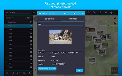
- Geotagged photos to give your important data a far more visual element than just a marker point
- Drop down forms for faster data collection
- Offline GPS tracking
- On-screen annotation tools to draw, add text and create shapes over your data
- Read and download a full suite of WMS/WFS & WMTS datasets
- Points, polygons and polylines
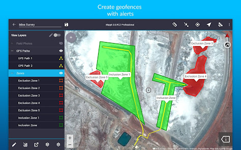
- Geofencing capabilities make sure you never breach a boundary
- Overlay coordinate grids see the exact distance between areas
- Street view mode with on-screen annotations available
- Import unlimited sized satellite, aerial, geological, topographic, elevation and other types of imagery in ECW and JP2 format
- Import and export popular GIS formats such as Shapefiles, JP2 and KML/KMZ
- Share your data between popular cloud storage such as Google Drive
Our clients have used our offline GIS app for a range of in-field tasks including:
- Field mapping
- Land surveying
- Vegetation management
- Forestry planning
- Environmental management
- Incident reporting
- Mine management
- Farm mapping
- Utility mapping
- Government planning
- Asset management
Leave internet worries, bulky equipment and inaccurate data in the past, and experience a more efficient future of data collection with Mappt™.
***NOTE: You are free to trial Mappt™ for 120 minutes. Once this time is up, you can either wait 8 hours for another 120 minutes, or purchase a monthly licence from US$29 to unlock full functionality. For more information about features and licensing tiers, please visit www.mappt.com.au/pricing.***
Mappt™ is used in industries spanning from environmental and agriculture, to mining and local government in over 130 countries worldwide.
They choose Mappt™ because it integrates with popular desktop GIS including ArcGIS and QGIS, and the user friendly interface hosts easy to use features that even those new to field data collection will master in minutes, including:
- Geotagged photos to give your important data a far more visual element than just a marker point
- Drop down forms for faster data collection
- Offline GPS tracking
- On-screen annotation tools to draw, add text and create shapes over your data
- Read and download a full suite of WMS/WFS & WMTS datasets
- Points, polygons and polylines
- Geofencing capabilities make sure you never breach a boundary
- Overlay coordinate grids see the exact distance between areas
- Street view mode with on-screen annotations available
- Import unlimited sized satellite, aerial, geological, topographic, elevation and other types of imagery in ECW and JP2 format
- Import and export popular GIS formats such as Shapefiles, JP2 and KML/KMZ
- Share your data between popular cloud storage such as Google Drive
Our clients have used our offline GIS app for a range of in-field tasks including:
- Field mapping
- Land surveying
- Vegetation management
- Forestry planning
- Environmental management
- Incident reporting
- Mine management
- Farm mapping
- Utility mapping
- Government planning
- Asset management
Leave internet worries, bulky equipment and inaccurate data in the past, and experience a more efficient future of data collection with Mappt™.
***NOTE: You are free to trial Mappt™ for 120 minutes. Once this time is up, you can either wait 8 hours for another 120 minutes, or purchase a monthly licence from US$29 to unlock full functionality. For more information about features and licensing tiers, please visit www.mappt.com.au/pricing.***
اپ ڈیٹ کردہ بتاریخ
سیفٹی اس بات کو سمجھنے کے ساتھ شروع ہوتی ہے کہ ڈویلپرز آپ کا ڈیٹا کیسے اکٹھا اور اس کا اشتراک کرتے ہیں۔ ڈیٹا کی رازداری اور سیکیورٹی کے طریقے آپ کے استعمال، علاقے اور عمر کی بنیاد پر مختلف ہو سکتے ہیں۔ ڈویلپر نے یہ معلومات فراہم کی ہے اور وقت کے ساتھ ساتھ اسے اپ ڈیٹ کر سکتا ہے۔

فریقین ثالث کے ساتھ کسی بھی ڈیٹا کا اشتراک نہیں کیا گیا
ڈویلپرز کے اشتراک کے اعلان کے بارے میں مزید جانیں

یہ ایپ ان ڈیٹا کی اقسام کو جمع کر سکتی ہے
ذاتی معلومات، ایپ سرگرمی اور 2 دیگر

ٹرانزٹ میں ڈیٹا مرموز کردہ ہے

آپ ڈیٹا حذف کروانے کیلئے درخواست کر سکتے ہیں
درجہ بندی اور جائزے
3.2
240 جائزے
نیا کیا ہے
- Improved Security: We've updated our app's security to protect your user license keys.
- New Feature: Now you can add detailed SOAR maps to your projects!
- Clearer EULA: We've made the End User License Agreement (EULA) easier to understand.
- Fixed Android Access: You can now access your media files properly, even on the latest Android versions.
- Other minor bug fixes and improvements
