

MapItFast- Field-based Mapping

4,0star
73 ta sharh
10 ming+
Yuklanmalar

Hamma uchun
info


Bu ilova haqida
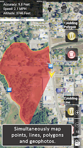
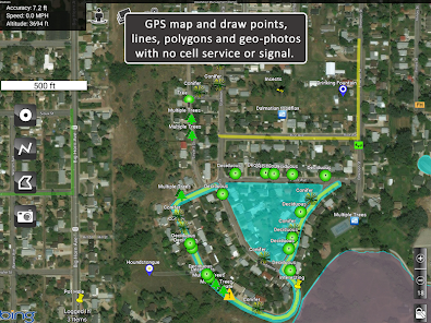
MapItFast transforms your phone or tablet into a powerful field mapping and data collection tool—even when you’re off the grid. Quickly create points, lines, polygons, and geophotos with a single tap with no GIS expertise required.
Key Free Features:
• Tap the icon to map objects instantly via GPS, or long-press to draw them by hand.
• Capture geophotos, measure distances, and calculate areas in real time.
• Pause or resume GPS tracking at any moment, and work on multiple lines or polygons simultaneously.
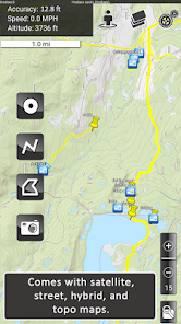
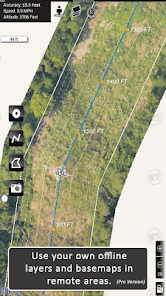
• Choose from aerial, street, and topo basemaps for a clear reference in any environment.
MapItFast Professional
Upgrade to the paid version for enterprise-level functionality and organize your work into projects, add custom basemaps and digital forms, and automatically sync everything to your private cloud account. MapItFast Professional includes web-based mapping features that seamlessly synchronize projects and user data across Android and iOS devices, fostering collaboration on unlimited projects and enabling custom form creation.
Key Paid Features
• Cloud-Based Sync: Access maps and data across devices and on the web.
• Real-Time Collaboration: A web portal shows projects, users, and updates as they happen.
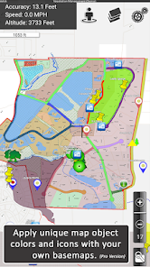
• Custom Maps & Symbology: Easily load and distribute your own mapping styles.
• Integrated Forms: Add attributes directly to map objects in the app.
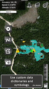
• Symbol Triggers: Auto-update map symbols as forms are completed.
• Custom Reports: Generate branded PDF or email reports with maps, photos, and form data.
• Advanced GIS Tools: Work with buffers, splits, donuts, and more.
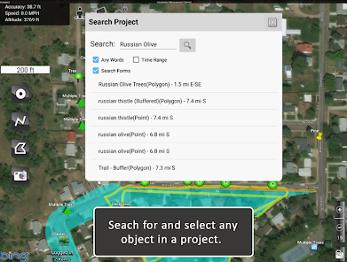
• Flexible Data Management: Search, sort, edit, copy, and move objects across projects.
• Shapefile Import/Export: Bring in shapefiles or export to KMZ, SHP, and GPX.
• Two-Way Sync: Real-time updates between field devices and your online account.
• User Permissions: Control project access and roles at individual or group levels.
Extend Your Capabilities
Enhance MapItFast’s capabilities with AgTerra’s hardware devices for real-time equipment activity tracking and mapping:
• SprayLogger: Automate pesticide application data logging and generate detailed reports.
• SnapMapper: Quickly create points and lines in MapItFast from any mechanical switch.
MapItFast is Perfect for Agriculture and Natural Resource Entities Performing:
• Vegetation management & pesticide reporting
• Mosquito trap inspection & vector control
• Field surveys & inspections
• Crop scouting
• Wildfire/disaster response & prevention
• Rangeland & water management
• Utilities & forestry operations
Simplify your field mapping process and streamline data management across your team or organization. Learn more about all our solutions at www.agterra.com.
Key Free Features:
• Tap the icon to map objects instantly via GPS, or long-press to draw them by hand.
• Capture geophotos, measure distances, and calculate areas in real time.
• Pause or resume GPS tracking at any moment, and work on multiple lines or polygons simultaneously.
• Choose from aerial, street, and topo basemaps for a clear reference in any environment.
MapItFast Professional
Upgrade to the paid version for enterprise-level functionality and organize your work into projects, add custom basemaps and digital forms, and automatically sync everything to your private cloud account. MapItFast Professional includes web-based mapping features that seamlessly synchronize projects and user data across Android and iOS devices, fostering collaboration on unlimited projects and enabling custom form creation.
Key Paid Features
• Cloud-Based Sync: Access maps and data across devices and on the web.
• Real-Time Collaboration: A web portal shows projects, users, and updates as they happen.
• Custom Maps & Symbology: Easily load and distribute your own mapping styles.
• Integrated Forms: Add attributes directly to map objects in the app.
• Symbol Triggers: Auto-update map symbols as forms are completed.
• Custom Reports: Generate branded PDF or email reports with maps, photos, and form data.
• Advanced GIS Tools: Work with buffers, splits, donuts, and more.
• Flexible Data Management: Search, sort, edit, copy, and move objects across projects.
• Shapefile Import/Export: Bring in shapefiles or export to KMZ, SHP, and GPX.
• Two-Way Sync: Real-time updates between field devices and your online account.
• User Permissions: Control project access and roles at individual or group levels.
Extend Your Capabilities
Enhance MapItFast’s capabilities with AgTerra’s hardware devices for real-time equipment activity tracking and mapping:
• SprayLogger: Automate pesticide application data logging and generate detailed reports.
• SnapMapper: Quickly create points and lines in MapItFast from any mechanical switch.
MapItFast is Perfect for Agriculture and Natural Resource Entities Performing:
• Vegetation management & pesticide reporting
• Mosquito trap inspection & vector control
• Field surveys & inspections
• Crop scouting
• Wildfire/disaster response & prevention
• Rangeland & water management
• Utilities & forestry operations
Simplify your field mapping process and streamline data management across your team or organization. Learn more about all our solutions at www.agterra.com.
Oxirgi yangilanish
Xavfsizlik — dastur ishlab chiquvchilar maʼlumotlaringizni qanday jamlashi va ulashishini tushunishdan boshlanadi. Maʼlumotlar maxfiyligi va xavfsizlik amaliyotlari ilovadan foydalanish, hudud va yoshga qarab farq qilishi mumkin. Bu axborot dastur ishlab chiquvchi tomonidan taqdim etilgan va keyinchalik yangilanishi mumkin.

Tashqi hamkorlarga hech qanday axborot ulashilmagan
Dastur ishlab chiquvchilar axborot ulashilishini qanday aytishi haqida batafsil

Ushbu ilova quyidagi axborot turlarini toʻplashi mumkin
Joylashuv va Suratlar va videolar

Maʼlumotlar uzatish vaqtida shifrlanadi

Maʼlumotlarni oʻchirishni soʻrashingiz mumkin
Reytinglar va sharhlar
4,2
50 ta sharh
Nima yangiliklar
Display Fixes
Fixes for SprayLogger Readings
Rapid Zoom
Fixes for SprayLogger Readings
Rapid Zoom
Ilova yuzasidan yordam
phone
Telefon raqami
+13076731050
Dasturchi haqida
Agterra Technologies, Inc.
ratherton@agterra.com
212 W Burkitt St
Sheridan, WY 82801
United States
+1 307-673-1050


