
geoportail.lu
4,0star
130 ta sharh
10 ming+
Yuklanmalar

Hamma uchun
info


Bu ilova haqida
The official mapping app from Luxemburg’s national geoportal, developed by the Cadastre & Topography Administration (ACT).
This app enables you to view topographic maps, aerial photos, and cadastral parcels as well as many other interesting datasets about Luxemburg via your mobile device.
✓SEARCH FOR PLACES: Search for places by names, toponymes, parcel numbers, coordinates etc…
✓Chose among more than 100 different data layers (as available on our website http://map.geoportal.lu)
✓Share your maps
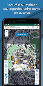
✓ Use maps in offline mode
!
Offline functionality:
Choose a specific zone to download to your device. The active map layers for this area will be available to use even when offline, for example when hiking in areas without network coverage. This functionality is also ideal to download our maps via Wi-Fi at home, without incurring excessive mobile data download charges or exceed your data quota.
!
✓ ACCESS QUALITY TRAILS
✓VISUALIZE HEIGHT PROFILES
✓ ENJOY A LOT OF OTHER FUNCTIONS
✓ create POIs on the map (thanks to the GPS, by coordinates , e.g Geocaching or inventories )
✓ Export GPX/KML files
WARNING: Continued use of GPS running in the background can dramatically decrease battery life. Continued use of maps in online mode may lead to unexpected costs due to high download traffic.
Check our PRIVACY POLICY at:
https://geoportail.lu/en/applications/mobile-apps/privacy-policy
This app enables you to view topographic maps, aerial photos, and cadastral parcels as well as many other interesting datasets about Luxemburg via your mobile device.
✓SEARCH FOR PLACES: Search for places by names, toponymes, parcel numbers, coordinates etc…
✓Chose among more than 100 different data layers (as available on our website http://map.geoportal.lu)
✓Share your maps
✓ Use maps in offline mode
!
Offline functionality:
Choose a specific zone to download to your device. The active map layers for this area will be available to use even when offline, for example when hiking in areas without network coverage. This functionality is also ideal to download our maps via Wi-Fi at home, without incurring excessive mobile data download charges or exceed your data quota.
!
✓ ACCESS QUALITY TRAILS
✓VISUALIZE HEIGHT PROFILES
✓ ENJOY A LOT OF OTHER FUNCTIONS
✓ create POIs on the map (thanks to the GPS, by coordinates , e.g Geocaching or inventories )
✓ Export GPX/KML files
WARNING: Continued use of GPS running in the background can dramatically decrease battery life. Continued use of maps in online mode may lead to unexpected costs due to high download traffic.
Check our PRIVACY POLICY at:
https://geoportail.lu/en/applications/mobile-apps/privacy-policy
Oxirgi yangilanish
Xavfsizlik — dastur ishlab chiquvchilar maʼlumotlaringizni qanday jamlashi va ulashishini tushinishdan boshlanadi. Maʼlumotlar maxfiyligi va xavfsizlik amaliyotlari ilovadan foydalanish, hudud va yoshga qarab farq qilishi mumkin. Bu axborot dastur ishlab chiquvchi tomonidan taqdim etilgan va keyinchalik yangilanishi mumkin.

Tashqi hamkorlarga hech qanday axborot ulashilmagan
Dastur ishlab chiquvchilar axborot ulashilishini qanday aytishi haqida batafsil

Ushbu ilova quyidagi axborot turlarini toʻplashi mumkin
Qurilma yoki boshqa identifikatorlar

Maʼlumotlar uzatish vaqtida shifrlanadi

Maʼlumotlarni oʻchirishni soʻrashingiz mumkin
Nima yangiliklar
- Download our vectortile style maps to use them in offline mode
- Small bug fixes
- Small bug fixes
Ilova yuzasidan yordam
phone
Telefon raqami
+352449011