
Wildfire Info
3,8star
191 ta sharh
50 ming+
Yuklanmalar

Hamma uchun
info


Bu ilova haqida
Disclaimer: This unofficial app does not represent any government agency and is not affiliated with any government agency. The sources of the data are the publicly accessible sources listed below.
Browse current wildfire and prescribed burn activity throughout all of the world.
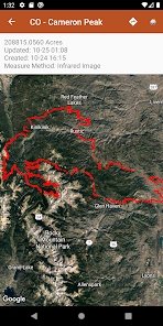
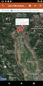
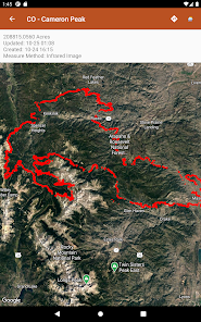
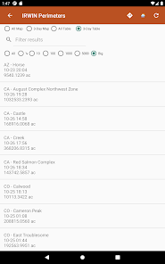
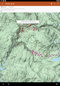
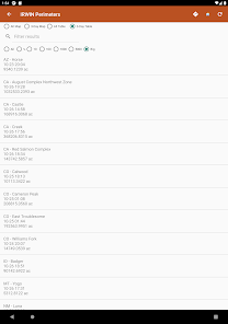
Active Wildfire Perimeter data from NIFC WFIGS. Tagged by state, search by name, and filter by acres burned. WFIGS stands for the Wildland Fire Interagency Geospatial Services (WFIGS) Group. NIFC stands for the National Interagency Fire Center. NIFC WFIGS Source URLs: https://www.nifc.gov/ with data hosted at https://data-nifc.opendata.arcgis.com/datasets/nifc::wfigs-current-interagency-fire-perimeters/about
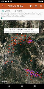
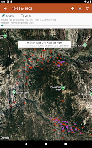
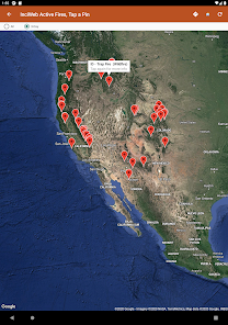
NASA MODIS and VIIRS satellite instruments data: Thermal hotspot maps by region show wildfire activity in the past 48 hours. See hotspot info including fire radiance power, brightness temperature, and confidence. NASA MODIS/VIIRS Source URL: https://firms.modaps.eosdis.nasa.gov/active_fire/ . MODIS stands for Moderate Resolution Imaging Spectroradiometer. VIIRS stands for Visible Infrared Imaging Radiometer Suite.
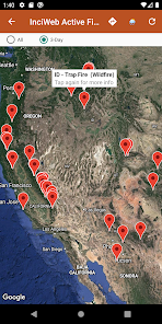
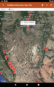
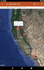
InciWeb & CAL FIRE active fire maps: hot-link to the corresponding official incident webpage. Inciweb Source URL: https://inciweb.wildfire.gov/ , CAL FIRE Source URL: https://www.fire.ca.gov/incidents
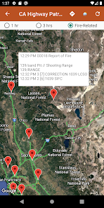
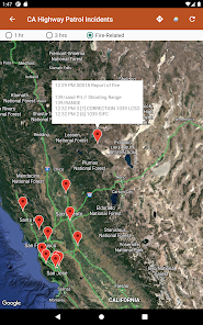
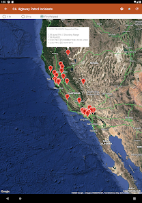
CHP (California Highway Patrol): Incidents in the past 3 hours related to fires are filtered out separately, all traffic incidents are included viewable by last 1 or 3 hours.CHP Source URL: https://cad.chp.ca.gov/Traffic.aspx
NESDIS GOES 16/17 Satellite Animations show wildfire smoke plumes, drought conditions, etc. from the satellite's perspective. NESDIS GOES Source URL: https://www.star.nesdis.noaa.gov. NESDIS stands for National Environmental Satellite, Data, and Information Service. GOES stands for
Geostationary Operational Environmental Satellite.
Links to current hyper-local weather summary conditions from NWS, NOAA, Government of Canada, and Government of Australia: including temperature, wind and gust conditions, and local forecasts anywhere in the USA, Canada, or Australia at your centered map location. NWS/NOAA Source URL: https://forecast.weather.gov/, Government of Canada Weather Source URL: https://weather.gc.ca/, Government of Australia Weather Source URL: http://www.bom.gov.au/
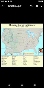
Wildfire Situation Reports section with mirrored PDFs from NIFC. NIFC Source URL: https://www.nifc.gov
Pull up the Google Maps app for an area with the embedded deep links.
There is a section for wildfire-related US government Twitter accounts viewable by map by approximate location or sorted into national and state sources in a table view. Twitter Source URLs: https://twitter.com
Information is posted as soon as it becomes available from WFIGS, NIFC, NASA, InciWeb, CAL FIRE, CHP, NESDIS, NOAA, NWS, Government of Canada, and Government of Australia.
Privacy Policy: https://davidgrossapps.com/privacy-policy.html
Browse current wildfire and prescribed burn activity throughout all of the world.
Active Wildfire Perimeter data from NIFC WFIGS. Tagged by state, search by name, and filter by acres burned. WFIGS stands for the Wildland Fire Interagency Geospatial Services (WFIGS) Group. NIFC stands for the National Interagency Fire Center. NIFC WFIGS Source URLs: https://www.nifc.gov/ with data hosted at https://data-nifc.opendata.arcgis.com/datasets/nifc::wfigs-current-interagency-fire-perimeters/about
NASA MODIS and VIIRS satellite instruments data: Thermal hotspot maps by region show wildfire activity in the past 48 hours. See hotspot info including fire radiance power, brightness temperature, and confidence. NASA MODIS/VIIRS Source URL: https://firms.modaps.eosdis.nasa.gov/active_fire/ . MODIS stands for Moderate Resolution Imaging Spectroradiometer. VIIRS stands for Visible Infrared Imaging Radiometer Suite.
InciWeb & CAL FIRE active fire maps: hot-link to the corresponding official incident webpage. Inciweb Source URL: https://inciweb.wildfire.gov/ , CAL FIRE Source URL: https://www.fire.ca.gov/incidents
CHP (California Highway Patrol): Incidents in the past 3 hours related to fires are filtered out separately, all traffic incidents are included viewable by last 1 or 3 hours.CHP Source URL: https://cad.chp.ca.gov/Traffic.aspx
NESDIS GOES 16/17 Satellite Animations show wildfire smoke plumes, drought conditions, etc. from the satellite's perspective. NESDIS GOES Source URL: https://www.star.nesdis.noaa.gov. NESDIS stands for National Environmental Satellite, Data, and Information Service. GOES stands for
Geostationary Operational Environmental Satellite.
Links to current hyper-local weather summary conditions from NWS, NOAA, Government of Canada, and Government of Australia: including temperature, wind and gust conditions, and local forecasts anywhere in the USA, Canada, or Australia at your centered map location. NWS/NOAA Source URL: https://forecast.weather.gov/, Government of Canada Weather Source URL: https://weather.gc.ca/, Government of Australia Weather Source URL: http://www.bom.gov.au/
Wildfire Situation Reports section with mirrored PDFs from NIFC. NIFC Source URL: https://www.nifc.gov
Pull up the Google Maps app for an area with the embedded deep links.
There is a section for wildfire-related US government Twitter accounts viewable by map by approximate location or sorted into national and state sources in a table view. Twitter Source URLs: https://twitter.com
Information is posted as soon as it becomes available from WFIGS, NIFC, NASA, InciWeb, CAL FIRE, CHP, NESDIS, NOAA, NWS, Government of Canada, and Government of Australia.
Privacy Policy: https://davidgrossapps.com/privacy-policy.html
Oxirgi yangilanish
Xavfsizlik — dastur ishlab chiquvchilar maʼlumotlaringizni qanday jamlashi va ulashishini tushinishdan boshlanadi. Maʼlumotlar maxfiyligi va xavfsizlik amaliyotlari ilovadan foydalanish, hudud va yoshga qarab farq qilishi mumkin. Bu axborot dastur ishlab chiquvchi tomonidan taqdim etilgan va keyinchalik yangilanishi mumkin.


Reytinglar va sharhlar
3,9
179 ta sharh
Nima yangiliklar
- Updated Google Maps
- Removed Air Quality sections
- Removed Lightning mapping in NESDIS section
- Removed some Situation Reports
- Updated the app's minimum Android SDK version from 19 to 21. The app's target Android SDK Version remains at 34.
- Removed Air Quality sections
- Removed Lightning mapping in NESDIS section
- Removed some Situation Reports
- Updated the app's minimum Android SDK version from 19 to 21. The app's target Android SDK Version remains at 34.
Ilova yuzasidan yordam
phone
Telefon raqami
+19515957097


