
Dynavix Navigation & Cameras
Ilova ichida xaridlar
3,7star
4,17 ming ta sharh
100 ming+
Yuklanmalar

Hamma uchun
info
Bu ilova haqida
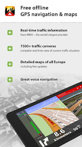
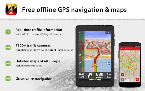
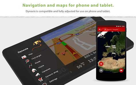
+ Online and free GPS navigation for Android including Android auto.
+ Lifetime map data updates several times a year. The maps are stored on the device, making them available anywhere, anytime.
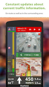
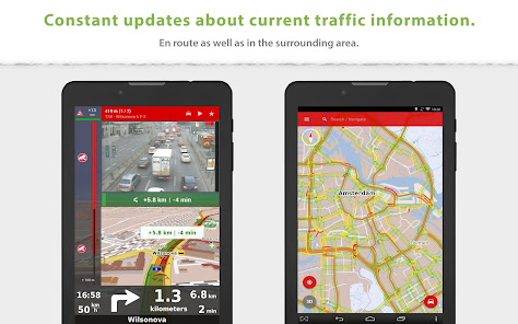
+ Real-time intelligent route guidance using traffic cameras.
______________________________________
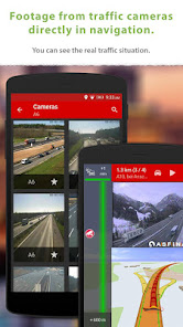
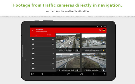
Snapshots from online traffic cameras near the planned route: Only Dynavix allows you to view data from traffic cameras located around the calculated route. In addition, Dynavix allows you to create custom lists of cameras, viewing data from cameras in the map, and other features. Dynavix currently supports access to over 7,500 traffic cameras across Europe.
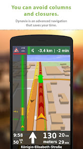
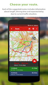
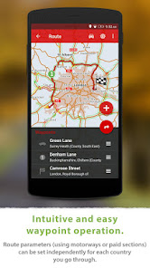
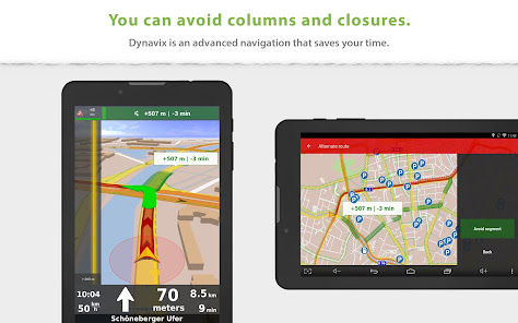
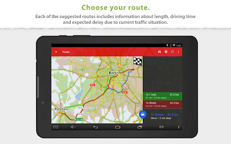
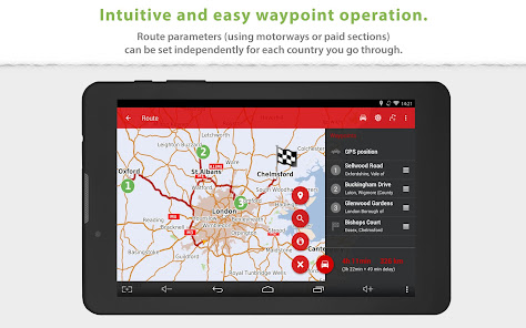
Advanced route planning using waypoints: The new Dynavix also significantly improves route planning with the use of waypoints. The planning is now very clear and adapted for use on mobile phones and tablets.
High-quality accurate maps: New Dynavix uses OpenStreetMap data. We believe the strength of the international community and current practice shows that OpenStreetMap are very detailed and often better than the maps from other providers.
The main functions of Dynavix:
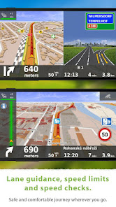
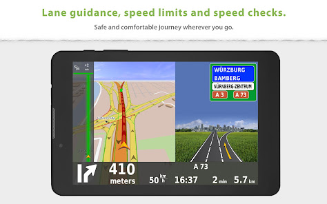
• Turn-by-turn offline voice navigation
• Views from online traffic cameras near the planned route
• Lifetime free map updates several times a year
• Android auto connectivity
• Advanced route planning using waypoints with the possibility of avoiding toll roads in certain countries or along the entire route
• Lane assistant and highway labels
• Full-text address search
• Alternative routes
• Support for voice commands via Bluetooth handsfree (Media mode or Phone call)
• Journey stats with possible export to *.csv
• Large database of points of interest
• 2D / 3D map view
• Speed check notification (with the possibility of importing community database radars)
• Speed limit warning
• Pedestrian navigation
• Wide range of view options personalization
Maps (stored in device memory):
Europe
Albania, Andorra, Belarus, Bosnia-Herzegovina, Bulgaria, Croatia, Czech Republic, Austria, Belgium, Denmark, Estonia, Finland, France, Germany, Gibraltar, Greece, Hungary, Italy, Ireland, Latvia, Liechtenstein, Lithuania, Luxembourg, Malta, Macedonia, Montenegro, Monaco, Netherlands, Norway, Slovakia, Slovenia, Spain, Poland Portugal, Romania, San Marino, Serbia, Sweden, Switzerland, Turkey, United Kingdom, Vatican City
Traffic information is available in the following countries:
Czech Republic, Belgium, Netherlands, Germany, Sweden, UK
North America
USA, Canada
______________________________________
For more information visit our website www.dynavix.com
If you like Dynavix navigation, we encourage you to write at least a short review.
Notes:
• Navigation can dramatically decrease battery life even running in the background. Make sure you keep the phone connected to the charger when using navigation.
• Using real-time traffic information requires an internet connection.
+ Lifetime map data updates several times a year. The maps are stored on the device, making them available anywhere, anytime.
+ Real-time intelligent route guidance using traffic cameras.
______________________________________
Snapshots from online traffic cameras near the planned route: Only Dynavix allows you to view data from traffic cameras located around the calculated route. In addition, Dynavix allows you to create custom lists of cameras, viewing data from cameras in the map, and other features. Dynavix currently supports access to over 7,500 traffic cameras across Europe.
Advanced route planning using waypoints: The new Dynavix also significantly improves route planning with the use of waypoints. The planning is now very clear and adapted for use on mobile phones and tablets.
High-quality accurate maps: New Dynavix uses OpenStreetMap data. We believe the strength of the international community and current practice shows that OpenStreetMap are very detailed and often better than the maps from other providers.
The main functions of Dynavix:
• Turn-by-turn offline voice navigation
• Views from online traffic cameras near the planned route
• Lifetime free map updates several times a year
• Android auto connectivity
• Advanced route planning using waypoints with the possibility of avoiding toll roads in certain countries or along the entire route
• Lane assistant and highway labels
• Full-text address search
• Alternative routes
• Support for voice commands via Bluetooth handsfree (Media mode or Phone call)
• Journey stats with possible export to *.csv
• Large database of points of interest
• 2D / 3D map view
• Speed check notification (with the possibility of importing community database radars)
• Speed limit warning
• Pedestrian navigation
• Wide range of view options personalization
Maps (stored in device memory):
Europe
Albania, Andorra, Belarus, Bosnia-Herzegovina, Bulgaria, Croatia, Czech Republic, Austria, Belgium, Denmark, Estonia, Finland, France, Germany, Gibraltar, Greece, Hungary, Italy, Ireland, Latvia, Liechtenstein, Lithuania, Luxembourg, Malta, Macedonia, Montenegro, Monaco, Netherlands, Norway, Slovakia, Slovenia, Spain, Poland Portugal, Romania, San Marino, Serbia, Sweden, Switzerland, Turkey, United Kingdom, Vatican City
Traffic information is available in the following countries:
Czech Republic, Belgium, Netherlands, Germany, Sweden, UK
North America
USA, Canada
______________________________________
For more information visit our website www.dynavix.com
If you like Dynavix navigation, we encourage you to write at least a short review.
Notes:
• Navigation can dramatically decrease battery life even running in the background. Make sure you keep the phone connected to the charger when using navigation.
• Using real-time traffic information requires an internet connection.
Oxirgi yangilanish
Xavfsizlik — dastur ishlab chiquvchilar maʼlumotlaringizni qanday jamlashi va ulashishini tushinishdan boshlanadi. Maʼlumotlar maxfiyligi va xavfsizlik amaliyotlari ilovadan foydalanish, hudud va yoshga qarab farq qilishi mumkin. Bu axborot dastur ishlab chiquvchi tomonidan taqdim etilgan va keyinchalik yangilanishi mumkin.

Tashqi hamkorlarga hech qanday axborot ulashilmagan
Dastur ishlab chiquvchilar axborot ulashilishini qanday aytishi haqida batafsil

Ushbu ilova quyidagi axborot turlarini toʻplashi mumkin
Joylashuv, Men haqimda va yana 4 ta

Maʼlumotlar uzatish vaqtida shifrlanadi

Maʼlumotlarni oʻchirishni soʻrashingiz mumkin
Reytinglar va sharhlar
3,6
3,81 ming ta sharh
Nima yangiliklar
+ Improved application stability