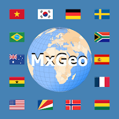
World atlas & world map MxGeo
4,2star
4,42 ming ta sharh
1 mln+
Yuklanmalar
Ustozlar tasdiqlagan

Hamma uchun
info
Bu ilova haqida
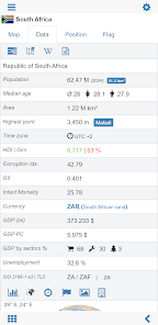
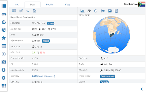
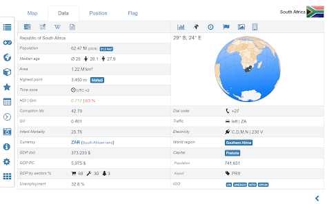
World atlas, world map and educational app for geography. Flags, position maps and basic data about 260 countries and territories of the world. Political maps with regional units and comprehensive economic and statistical country data for all African countries.
Designed for smartphones and tablets.
• Flags, essential maps and basic data for more than 250 countries and territories of the world
• Search for countries, major cities, rivers, mountains, lakes or coordinates
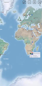
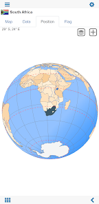
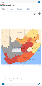
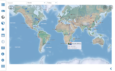
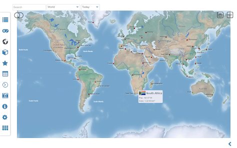
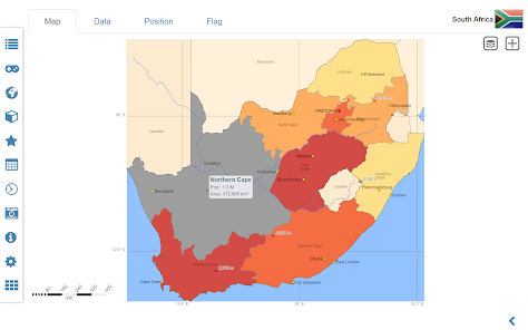
• Interactive political world and continent maps
• Shaded relief layer for world and continent maps
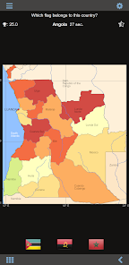
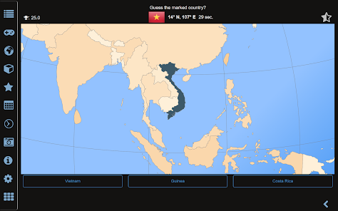
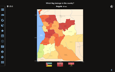
• Geography quiz challenge for playful learning
• Country comparison, favorites and distance calculator
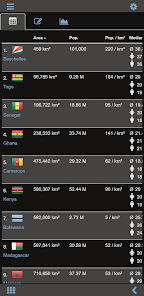
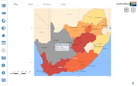
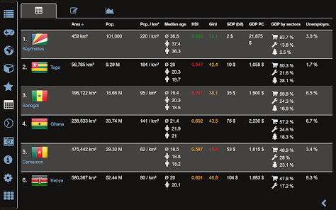
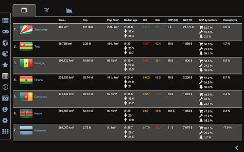
• Comprehensive maps and data of all African countries
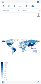
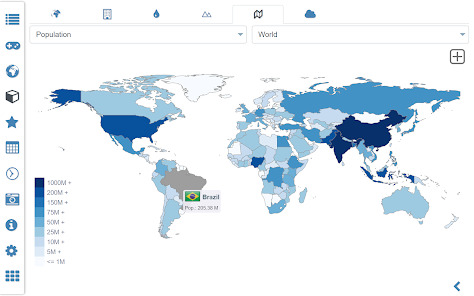
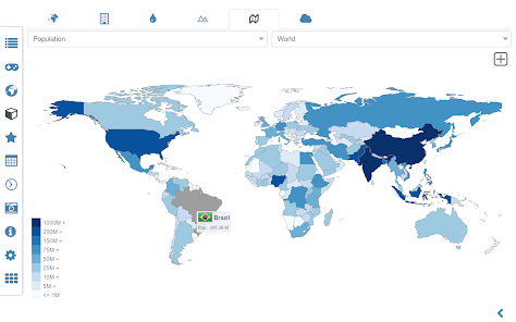
• Choropleth maps: area and population
• World clock and distance calculator
• World-explorer: the smallest, largest, ... countries
• No online connection required
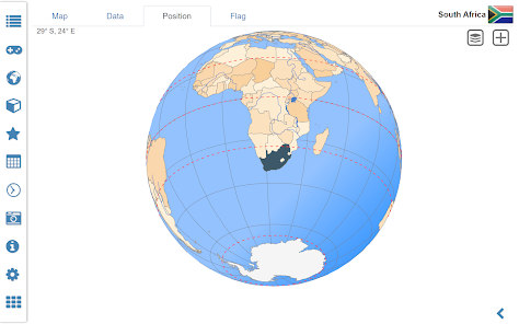
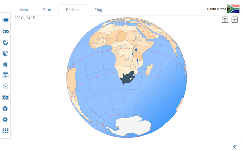
Explore the world by political world and continent maps offline maps. Learn where each country in the world is located. View its position highlighted on a digital globe. Create your favorite color theme or choose from different color schemes for map display.
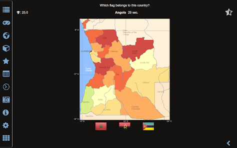
Do you know the flag of Zambia? Yes? Perfect. Do you also know in which country Mount Kilimanjaro is located? “World atlas & world map MxGeo Free” Quiz helps you acquire a geographic literacy in a playful manner.
Choose from six geo guessing games:
• Test your knowledge about the capitals of Africa
• Do you know the ISO countries codes?
• Recognize the proper country flag based on the outline map
• Do you know the top-level domains of each country?
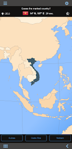
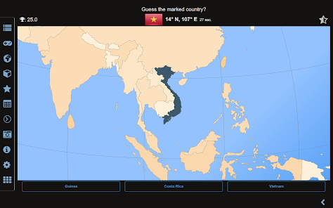
• Guess the highlighted country on the virtual globe
• Do you know the mountains of Africa?
Geo learning app and educational game which is fun for everyone whether children, adults, seniors or teachers. Get ready for your next stay abroad while enjoying this great world almanac including time zones and statistical data, such as population growth and other key figures. Or prepare for your next geography lesson with this genius digital world map. If not traveling our world atlas lets you explore the world just only virtually.
Free version includes comprehensive data and maps for all African countries. Get “World atlas & world map MxGeo Pro” with detailed data and maps including regional units and capitals for more than 260 countries and territories of the world: Europe, Asia, North America, Africa, Oceania and South America.
Designed for smartphones and tablets.
• Flags, essential maps and basic data for more than 250 countries and territories of the world
• Search for countries, major cities, rivers, mountains, lakes or coordinates
• Interactive political world and continent maps
• Shaded relief layer for world and continent maps
• Geography quiz challenge for playful learning
• Country comparison, favorites and distance calculator
• Comprehensive maps and data of all African countries
• Choropleth maps: area and population
• World clock and distance calculator
• World-explorer: the smallest, largest, ... countries
• No online connection required
Explore the world by political world and continent maps offline maps. Learn where each country in the world is located. View its position highlighted on a digital globe. Create your favorite color theme or choose from different color schemes for map display.
Do you know the flag of Zambia? Yes? Perfect. Do you also know in which country Mount Kilimanjaro is located? “World atlas & world map MxGeo Free” Quiz helps you acquire a geographic literacy in a playful manner.
Choose from six geo guessing games:
• Test your knowledge about the capitals of Africa
• Do you know the ISO countries codes?
• Recognize the proper country flag based on the outline map
• Do you know the top-level domains of each country?
• Guess the highlighted country on the virtual globe
• Do you know the mountains of Africa?
Geo learning app and educational game which is fun for everyone whether children, adults, seniors or teachers. Get ready for your next stay abroad while enjoying this great world almanac including time zones and statistical data, such as population growth and other key figures. Or prepare for your next geography lesson with this genius digital world map. If not traveling our world atlas lets you explore the world just only virtually.
Free version includes comprehensive data and maps for all African countries. Get “World atlas & world map MxGeo Pro” with detailed data and maps including regional units and capitals for more than 260 countries and territories of the world: Europe, Asia, North America, Africa, Oceania and South America.
Oxirgi yangilanish
Xavfsizlik — dastur ishlab chiquvchilar maʼlumotlaringizni qanday jamlashi va ulashishini tushinishdan boshlanadi. Maʼlumotlar maxfiyligi va xavfsizlik amaliyotlari ilovadan foydalanish, hudud va yoshga qarab farq qilishi mumkin. Bu axborot dastur ishlab chiquvchi tomonidan taqdim etilgan va keyinchalik yangilanishi mumkin.

Tashqi hamkorlarga hech qanday axborot ulashilmagan
Dastur ishlab chiquvchilar axborot ulashilishini qanday aytishi haqida batafsil

Hech qanday maʼlumot jamlanmagan
Dastur ishlab chiquvchilar axborot jamlanishini qanday aytishi haqida batafsil

Google Play “Butun oila uchun” dasturi qoidalariga amal qiladi
Reytinglar va sharhlar
4,3
4,03 ming ta sharh

Gerakl
- Nomaqbul deb belgilash
26-avgust, 2022
Rus tili yogakan
10 kishi bu sharhni foydali deb topgan

Akmal Bóriyev
- Nomaqbul deb belgilash
20-yanvar, 2023
Ilova zoʻr
12 kishi bu sharhni foydali deb topgan

Ramazon Xaydarov
- Nomaqbul deb belgilash
12-oktabr, 2021
Zor ilova shu ekan lekin haritalar ichida
19 kishi bu sharhni foydali deb topgan
Nima yangiliklar
• Updates for maps and data
• Bug fixes and improvements
• Enhanced chart visualization
8.x:
• Improved quiz questions choice
• Country comparison and World Explorer new key indicator: population density
• New choropleth map: population density
• Search for countries, major cities, rivers, mountains, lakes and coordinates
• World Explorer: largest cities, longest rivers and highest mountains


