LunarMap Lite
Reklamalar mavjud
3,7star
258 ta sharh
50 ming+
Yuklanmalar

Hamma uchun
info

Bu ilova haqida
Moon maps galore! Scroll, zoom and search through high resolution US Geological Survey and NASA maps. LunarMap is fun for anybody who wants to see and know more about earth's lovely satellite and is a great companion for amateur astronomy observations through a telescope.
The Lite version watermarks zoom levels above 8X and does not include terminator (shadow line) display and satellite features (e.g., it includes Plato but not Plato B).
Features of LunarMap include:
- Nearside and farside of the moon
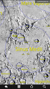
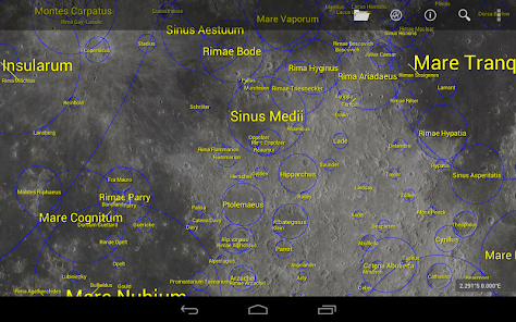
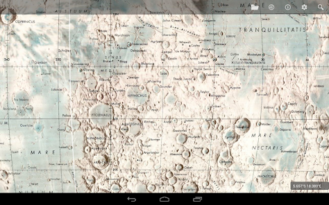
- Realistic US Geological Survey relief map (5120x5120 resolution)
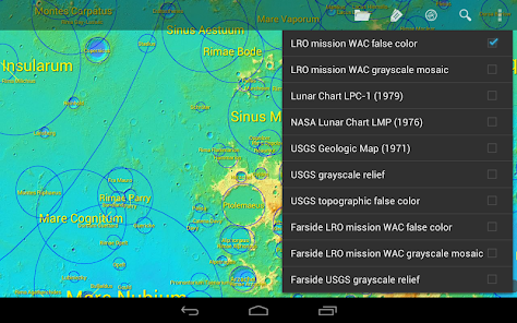
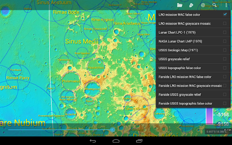
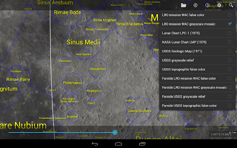
- Beautiful photographic map from the Lunar Reconnaissance Orbiter's Wide Angle Camera (nearside 20480x20480)
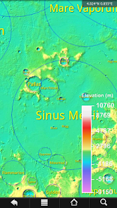
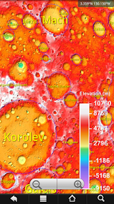
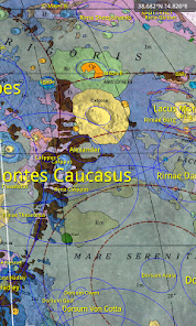
- Color-coded topological maps from both the USGS and NASA
- Realtime terminator (shadow) line
- Searchable labels for over 1900 craters, maria, mountains, valleys, Apollo landing sites and more, based on International Astronomical Union data; tap on feature for more information or to lookup in Wikipedia
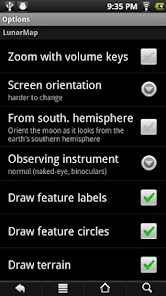
- Rotate and/or flip the map to match your telescope's eyepiece view, or for users in the southern hemisphere
- Zoom with two fingers (multitouch devices only), on-screen buttons or volume keys
- Customize colors, labels shown and other features
- Optionally lock screen rotation or make it harder to change so you need to turn the device further than usual to rotate to prevent accidental screen rotations while observing
- The maps are 2D. The nearside maps are projected to show a small portion of the farside, since libration can reveal a small portion of the farside
Note: To save app download time, maps other than the USGS relief nearside map involve an additional free in-app download, hence the Internet permission.
The Lite version watermarks zoom levels above 8X and does not include terminator (shadow line) display and satellite features (e.g., it includes Plato but not Plato B).
Features of LunarMap include:
- Nearside and farside of the moon
- Realistic US Geological Survey relief map (5120x5120 resolution)
- Beautiful photographic map from the Lunar Reconnaissance Orbiter's Wide Angle Camera (nearside 20480x20480)
- Color-coded topological maps from both the USGS and NASA
- Realtime terminator (shadow) line
- Searchable labels for over 1900 craters, maria, mountains, valleys, Apollo landing sites and more, based on International Astronomical Union data; tap on feature for more information or to lookup in Wikipedia
- Rotate and/or flip the map to match your telescope's eyepiece view, or for users in the southern hemisphere
- Zoom with two fingers (multitouch devices only), on-screen buttons or volume keys
- Customize colors, labels shown and other features
- Optionally lock screen rotation or make it harder to change so you need to turn the device further than usual to rotate to prevent accidental screen rotations while observing
- The maps are 2D. The nearside maps are projected to show a small portion of the farside, since libration can reveal a small portion of the farside
Note: To save app download time, maps other than the USGS relief nearside map involve an additional free in-app download, hence the Internet permission.
Oxirgi yangilanish
Xavfsizlik — dastur ishlab chiquvchilar maʼlumotlaringizni qanday jamlashi va ulashishini tushunishdan boshlanadi. Maʼlumotlar maxfiyligi va xavfsizlik amaliyotlari ilovadan foydalanish, hudud va yoshga qarab farq qilishi mumkin. Bu axborot dastur ishlab chiquvchi tomonidan taqdim etilgan va keyinchalik yangilanishi mumkin.


Reytinglar va sharhlar
3,8
224 ta sharh
Nima yangiliklar
1.45: Modern devices
1.40: Optimization; new map format; giant farside WAC map
1.34: Giant 20480x20480 nearside WAC map
1.30: Actionbar
1.21: Restore some missing labels
1.20: Lite version now watermarks the map at zoom levels above 8X (the previous version pixelated at that point) but now includes all the maps from the HD version!
1.14: Minor optimization and bug fixes
1.12: Add option to remove zoom buttons
1.11: Add astronaut named features
1.10: Add over 7000 satellite features
Ilova yuzasidan yordam
Dasturchi haqida
Alexander Pruss
omegacentaurisoftware@gmail.com
82 Cottonwood St
Waco, TX 76706-1645
United States
undefined


