
TcpGPS - Surveying with GNSS

1万+
次下载

适合所有人
info


关于此应用
TcpGPS 是一款面向测量专业人士的应用程序,可促进地块、城市地区和基础设施的数据收集和放样。它需要高精度的 GPS/GNSS 接收器。
主要特点:
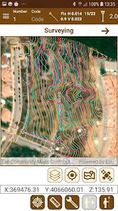
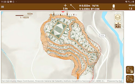
底图🗺
使用覆盖全球的 ESRITM 底图,可以以街道、卫星或地形模式查看。您还可以在本地和云端上传 DXF、DWG、GML、KML、KMZ 和形状格式的文件,并添加 Web 地图服务 (WMS)。
该程序包括大地测量系统的 EPSG 数据库,能够与各国组织的不同坐标参考系统配合使用,还可以定义本地系统。
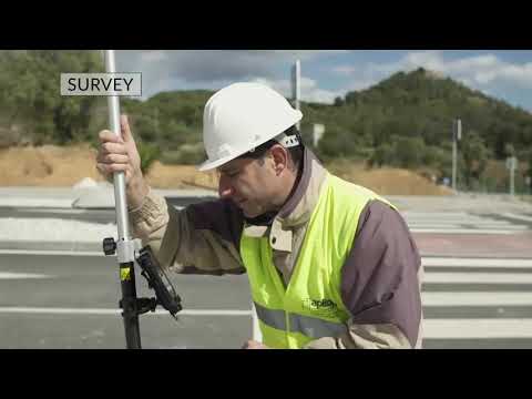
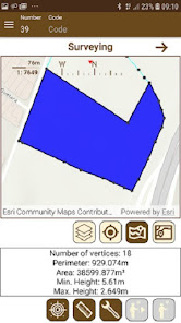
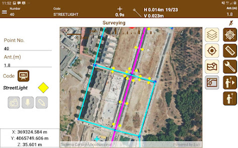
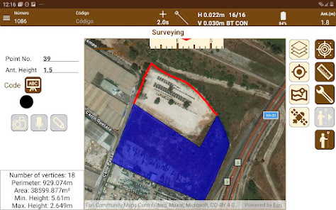
测量🦺
该应用程序可以非常轻松地测量地形点以及线性和多边形实体,这些实体是分层绘制并使用自定义符号系统的。连续模式允许您自动记录点,指定距离、时间或坡度间隔。
TcpGPS始终控制位置类型、水平和垂直精度、卫星数量、实时年龄等,并在任何指标超出容差时发出警告。还可以设置最短观察时间并使用纪元。
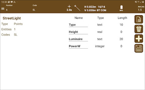
照片、语音注释和可选代码可以与对象以及用户定义的属性相关联,非常适合 GIS 项目。
所有收集到的数据都可以导出为多种格式并在应用程序内共享、存储在云中或通过电子邮件或其他方式发送。
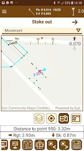
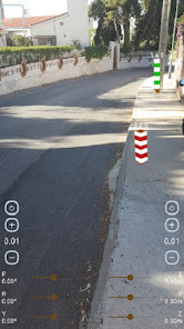
监视📍
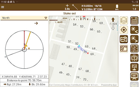
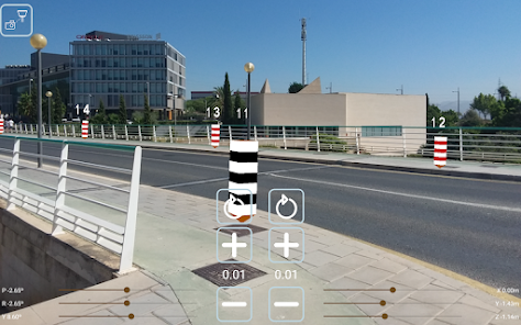
可以对制图的点、线和折线进行放样,以图形方式指定它们或通过各种标准选择它们。该应用程序提供了不同的帮助模式,例如地图、指南针、目标和增强现实。还可以激活语音提示或声音。
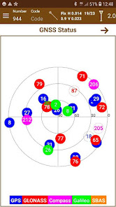
GNSS 接收器📡
该软件可让您轻松连接到任何符合 NMEA 标准的接收器。此外,您可以配置集成在设备中或通过蓝牙连接的各种接收器,以在基站、流动站或静态模式下工作,并通过无线电或互联网对来自收集器或设备本身的数据进行修正。
状态栏时刻显示位置类型、精度、IMU状态等,支持GPS、GLONASS、北斗、伽利略和SBAS星座。
专业版
雄心勃勃的项目需要处于技术前沿的工具来最大限度地提高生产力并取得成功。
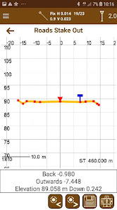
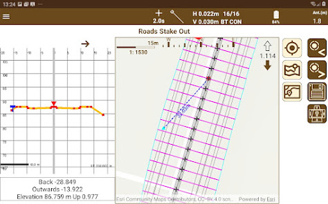
TcpGPS 专业版对于处理一般公路、铁路和线性项目非常有用,能够导入 LandXML 文件和其他格式。可以相对于路线或特定顶点(例如道路边缘、路肩、路缘、路面基础)放样点......还可以使用坡度控制的特定选项。
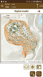
该程序从可选点和断裂线生成数字地形模型和等高线。还可以将当前标高与参考表面的标高进行比较。
主要特点:
底图🗺
使用覆盖全球的 ESRITM 底图,可以以街道、卫星或地形模式查看。您还可以在本地和云端上传 DXF、DWG、GML、KML、KMZ 和形状格式的文件,并添加 Web 地图服务 (WMS)。
该程序包括大地测量系统的 EPSG 数据库,能够与各国组织的不同坐标参考系统配合使用,还可以定义本地系统。
测量🦺
该应用程序可以非常轻松地测量地形点以及线性和多边形实体,这些实体是分层绘制并使用自定义符号系统的。连续模式允许您自动记录点,指定距离、时间或坡度间隔。
TcpGPS始终控制位置类型、水平和垂直精度、卫星数量、实时年龄等,并在任何指标超出容差时发出警告。还可以设置最短观察时间并使用纪元。
照片、语音注释和可选代码可以与对象以及用户定义的属性相关联,非常适合 GIS 项目。
所有收集到的数据都可以导出为多种格式并在应用程序内共享、存储在云中或通过电子邮件或其他方式发送。
监视📍
可以对制图的点、线和折线进行放样,以图形方式指定它们或通过各种标准选择它们。该应用程序提供了不同的帮助模式,例如地图、指南针、目标和增强现实。还可以激活语音提示或声音。
GNSS 接收器📡
该软件可让您轻松连接到任何符合 NMEA 标准的接收器。此外,您可以配置集成在设备中或通过蓝牙连接的各种接收器,以在基站、流动站或静态模式下工作,并通过无线电或互联网对来自收集器或设备本身的数据进行修正。
状态栏时刻显示位置类型、精度、IMU状态等,支持GPS、GLONASS、北斗、伽利略和SBAS星座。
专业版
雄心勃勃的项目需要处于技术前沿的工具来最大限度地提高生产力并取得成功。
TcpGPS 专业版对于处理一般公路、铁路和线性项目非常有用,能够导入 LandXML 文件和其他格式。可以相对于路线或特定顶点(例如道路边缘、路肩、路缘、路面基础)放样点......还可以使用坡度控制的特定选项。
该程序从可选点和断裂线生成数字地形模型和等高线。还可以将当前标高与参考表面的标高进行比较。
更新日期


新功能
Drawing of line and polygonal entities graphically linking points
Volume calculation of terrain movement
Definition of local systems by parameters (translations, rotations and scale)
Geodesy files have been added to the application itself
Voice recognition for point codes in Android 13 or above has been improved, transform numbers from letters to single characters
Request attributes after taking a point
Ntrip servers by URL instead of IP
Bugfixes