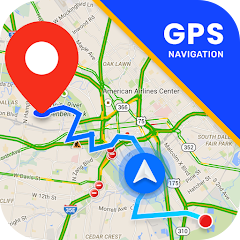
Maps Navigation
包含广告
3.8star
286条评价
10万+
次下载

适合所有人
info
关于此应用
GPS Maps Navigation is a mobile application for the Android that uses an Internet connection to a GPS navigation system to provide turn-by-turn voice-guided instructions on how to arrive at a given destination.
The application requires a connection to Internet data (e.g. 3G, 4G, 5G, WiFi, etc.) and normally uses a GPS satellite connection to determine its location.
A user can enter a destination into the application, which will plot a path to it. The app displays the user's progress along the route and issues instructions for each turn.
Features
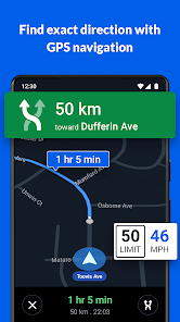
Get there faster with real-time updates
• Beat traffic with real-time ETAs and traffic conditions
• Catch your bus, train, or ride-share with real-time transit info
• Save time with automatic rerouting based on live traffic, incidents, and road closure
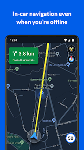
• Offline maps to search and navigate without an internet connection
• Street View and indoor imagery for restaurants, shops, museums and more
• Indoor maps to quickly find your way inside big places like airports, malls and stadiums
Know what’s open in your area and their latest business hours
• Find local restaurants offering delivery and takeout
Find the best route with automatic rerouting based on live traffic, incidents, and road closure
• Create lists of your important places
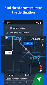
Search
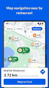
Instead of searching for an address or a street name, the application can also search by name, for example guide the user to a nearby restaurant by being given the name of the restaurant. The application can also take phrases such as “a place with burgers” and suggest nearby destinations that match the phrase.
The application can receive a voice input instead of typing the destination on the device.
Multiple views
Traffic: The application's traffic congestion map shows the route marks with different colours based on the current traffic along the route.
The traffic is measured by data from local road services such as highway cameras, as well as speed and location information from other Android devices that are accessing Maps for Mobile.
Satellite: The application displays a route from a bird’s eye view using satellite imagery.
Street: The Street View feature displays a route from first-person view as which automatically changes as the user travels along the route.
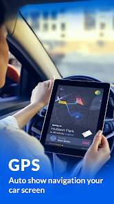
Car dock mode
Users can dock their Android device in a car using a special car dock for the device (which may or may not come with the device). Once docked, the device will enter this mode, enabling for easier access to the navigation features at an arm’s length.
Walking and transit
The application provides voice navigation for walking and previously for transit directions. In its current iteration navigation is not available for transit, only a list of directions is provided. The transit directions are available in 400 cities around the world.
Offline guidance
Once the user has searched for a destination, the map will cache along the intended route. It is also possible to download a map over a certain area and store it on the phone, which can be useful when there are high roaming charges or expected slow connection. The application requires an Internet connection to search for the route unless an offline map is downloaded, but once a route has been found the user no longer requires an Internet connection as the route is temporarily saved onto the device, unless an offline map has been downloaded to the device's local storage.
The application requires a connection to Internet data (e.g. 3G, 4G, 5G, WiFi, etc.) and normally uses a GPS satellite connection to determine its location.
A user can enter a destination into the application, which will plot a path to it. The app displays the user's progress along the route and issues instructions for each turn.
Features
Get there faster with real-time updates
• Beat traffic with real-time ETAs and traffic conditions
• Catch your bus, train, or ride-share with real-time transit info
• Save time with automatic rerouting based on live traffic, incidents, and road closure
• Offline maps to search and navigate without an internet connection
• Street View and indoor imagery for restaurants, shops, museums and more
• Indoor maps to quickly find your way inside big places like airports, malls and stadiums
Know what’s open in your area and their latest business hours
• Find local restaurants offering delivery and takeout
Find the best route with automatic rerouting based on live traffic, incidents, and road closure
• Create lists of your important places
Search
Instead of searching for an address or a street name, the application can also search by name, for example guide the user to a nearby restaurant by being given the name of the restaurant. The application can also take phrases such as “a place with burgers” and suggest nearby destinations that match the phrase.
The application can receive a voice input instead of typing the destination on the device.
Multiple views
Traffic: The application's traffic congestion map shows the route marks with different colours based on the current traffic along the route.
The traffic is measured by data from local road services such as highway cameras, as well as speed and location information from other Android devices that are accessing Maps for Mobile.
Satellite: The application displays a route from a bird’s eye view using satellite imagery.
Street: The Street View feature displays a route from first-person view as which automatically changes as the user travels along the route.
Car dock mode
Users can dock their Android device in a car using a special car dock for the device (which may or may not come with the device). Once docked, the device will enter this mode, enabling for easier access to the navigation features at an arm’s length.
Walking and transit
The application provides voice navigation for walking and previously for transit directions. In its current iteration navigation is not available for transit, only a list of directions is provided. The transit directions are available in 400 cities around the world.
Offline guidance
Once the user has searched for a destination, the map will cache along the intended route. It is also possible to download a map over a certain area and store it on the phone, which can be useful when there are high roaming charges or expected slow connection. The application requires an Internet connection to search for the route unless an offline map is downloaded, but once a route has been found the user no longer requires an Internet connection as the route is temporarily saved onto the device, unless an offline map has been downloaded to the device's local storage.
更新日期
安全始于了解开发者如何收集和分享数据。数据隐私保护和安全措施可能会因您的使用情况、所在地区和用户年龄而异。此类信息由开发者提供,可能会随时间更新。


评分和评价
3.9
282条评价


