
Farsider: Offline Navigation
In-app purchases


Everyone
info
10+
Downloads


About this app
Farsider is offline navigation for the roads worth the trip: curvy roads and gravel, maps that work without signal, and your crew on the map. Made by motorcyclists, for anyone who rides or drives for the road itself.
ROUTES WORTH THE TRIP
• Pick between route alternatives, each with its time, distance and how curvy it is.
• Avoid motorways, prefer back roads, or go looking for gravel.
• Hairpins, climbs and descents with the height profile ahead, and the speed limit always in view.
• Clear turn-by-turn voice, lane guidance in cities, and a big, glanceable cockpit you lay out yourself.
• Zoom the navigation view out to see more of the road ahead, or in for busy towns.
OFFLINE MAPS
• Download whole countries and ride without signal: maps, routing and search all work offline.
• Road and topographic maps: contour lines, relief, and passes with their heights.
• Day and night themes that switch by themselves, smoothly, at dusk and in tunnels.
GRAVEL AND ADVENTURE
• Know every kilometre of unpaved road before you reach it: the surface ahead, how much is gravel, and where it ends.
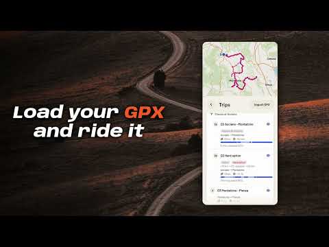
• Multi-day trips show each day's distance, time and share of gravel, with the hard options marked.
TOGETHER ON THE ROAD
• Create a group, share a QR code or a link, and see your friends live on the map with their speed and heading, on bikes or in cars.
• Send the group a route, or share a whole GPX trip so everyone rides the same days.
• No account needed: a name and an avatar are enough.
GPX TRIPS
• Import GPX files from Files, mail or messages. Farsider splits them into days and sections with km, time and surface, shows your waypoints on the map, and starts any day with one tap.
• Ride a track as drawn, reversed, or from where you join it.
WEATHER ON YOUR WAY
• Live rain radar with a short-term forecast you can scrub through.
• Weather along your route: where and when you'll meet rain, before you leave.
• A heads-up while riding when rain is ahead, and a place to wait out a short shower.
THINGS WORTH STOPPING FOR
• "Coming up" shows viewpoints, passes and places of interest ahead; one tap adds a stop.
• Fuel, food and coffee along the route, with opening hours.
• Search by what you need ("breakfast", "tyre repair", "pharmacy"), offline.
• Home and Work one tap away.
BUILT FOR THE RIDE
• A navigation notification on Android and a Live Activity on iPhone, on the lock screen.
• Keeps guiding when the GPS drops in a tunnel.
• Anonymous usage statistics only, with an off switch. No ads, no tracking.
FARSIDER PRO
Farsider is free to ride with. Farsider Pro adds:
• Local guide: short spoken stories about the places you ride through, timed between your turns.
• Satellite view, to scout gravel roads and tracks before you ride them. Pro is a monthly or yearly subscription, with a 7-day free trial for new subscribers. Payment is charged to your App Store or Google Play account when you confirm the purchase (after the trial, if you take it). The subscription renews automatically unless it is cancelled at least 24 hours before the end of the current period; you can manage or cancel it in your account settings.
Terms: https://farsider.app/terms
Privacy: https://farsider.app/privacy
Map data © OpenStreetMap contributors.
Offline maps and navigation for adventure, curvy roads, gravel and group rides
Updated on
Safety starts with understanding how developers collect and share your data. Data privacy and security practices may vary based on your use, region, and age. The developer provided this information and may update it over time.
- No data shared with third partiesLearn more about how developers declare sharing
- This app may collect these data typesLocation
- Data is encrypted in transit
- Data can’t be deleted


What’s new
• A tidier menu: four groups, an icon on every row, and clearer names (Map display, Offline maps, Ride log).
• Alerts has one row per warning, with its own settings under it.
• A recorded ride's page charts height and speed along the ride (with Pro).
• Voice is Off, Alerts or Full on the Ride sheet too, and cards step aside while you pan the map.
• Runs on Android 9 and newer.
• Alerts has one row per warning, with its own settings under it.
• A recorded ride's page charts height and speed along the ride (with Pro).
• Voice is Off, Alerts or Full on the Ride sheet too, and cards step aside while you pan the map.
• Runs on Android 9 and newer.
App support
About the developer
Verano Solutions B.V.
hola@patabrava.app
Korte Lijnbaanssteeg 1 K.4439
1012 SL Amsterdam
Netherlands
+971 54 755 2099