
Bahía Arbolado
100+
Downloads

Everyone
info


About this app
Arbolado Bahía is an application developed by the Secretariat of Modernization and Open Government of the Municipality of Bahía Blanca (Buenos Aires, Argentina).
It was designed for the General Directorate of Public Areas with the idea of conducting a census of public trees and knowing the general condition of the trees in the city.
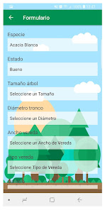
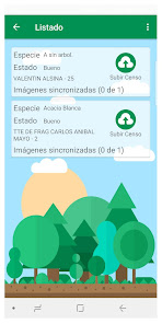
It is a simple and agile tool that, through a very simple form, seeks to collect the most important data of each tree: species, diameter, size, etc. These basic data are completed, one or several photos are taken and sent, and that's it!
Now each tree will appear georeferenced on the map of the city, with its information and its photos.
It was designed for the General Directorate of Public Areas with the idea of conducting a census of public trees and knowing the general condition of the trees in the city.
It is a simple and agile tool that, through a very simple form, seeks to collect the most important data of each tree: species, diameter, size, etc. These basic data are completed, one or several photos are taken and sent, and that's it!
Now each tree will appear georeferenced on the map of the city, with its information and its photos.
Updated on
Data safety
Developers can show information here about how their app collects and uses your data. Learn more about data safety

No information available