Mappt: GIS Data Collection
In-App-Käufe
3.4star
279 Rezensionen
50 Tsg.+
Downloads

Jedes Alter
info


Über diese App
Mappt™ is a powerful GIS (Geographic Information System) data collection app that allows users to create, edit, store and share location-based data with one light, compact device.
Mappt™ is used in industries spanning from environmental and agriculture, to mining and local government in over 130 countries worldwide.
They choose Mappt™ because it integrates with popular desktop GIS including ArcGIS and QGIS, and the user friendly interface hosts easy to use features that even those new to field data collection will master in minutes, including:
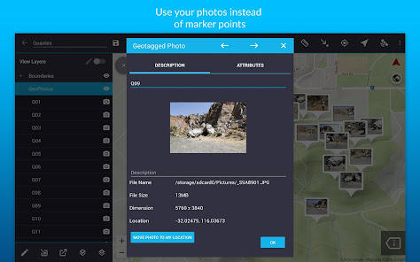
- Geotagged photos to give your important data a far more visual element than just a marker point
- Drop down forms for faster data collection
- Offline GPS tracking
- On-screen annotation tools to draw, add text and create shapes over your data
- Read and download a full suite of WMS/WFS & WMTS datasets
- Points, polygons and polylines
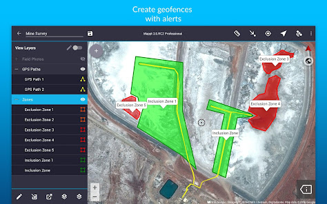
- Geofencing capabilities make sure you never breach a boundary
- Overlay coordinate grids see the exact distance between areas
- Street view mode with on-screen annotations available
- Import unlimited sized satellite, aerial, geological, topographic, elevation and other types of imagery in ECW and JP2 format
- Import and export popular GIS formats such as Shapefiles, JP2 and KML/KMZ
- Share your data between popular cloud storage such as Google Drive
Our clients have used our offline GIS app for a range of in-field tasks including:
- Field mapping
- Land surveying
- Vegetation management
- Forestry planning
- Environmental management
- Incident reporting
- Mine management
- Farm mapping
- Utility mapping
- Government planning
- Asset management
Leave internet worries, bulky equipment and inaccurate data in the past, and experience a more efficient future of data collection with Mappt™.
***NOTE: You are free to trial Mappt™ for 120 minutes. Once this time is up, you can either wait 8 hours for another 120 minutes, or purchase a monthly licence from US$29 to unlock full functionality. For more information about features and licensing tiers, please visit www.mappt.com.au/pricing.***
Mappt™ is used in industries spanning from environmental and agriculture, to mining and local government in over 130 countries worldwide.
They choose Mappt™ because it integrates with popular desktop GIS including ArcGIS and QGIS, and the user friendly interface hosts easy to use features that even those new to field data collection will master in minutes, including:
- Geotagged photos to give your important data a far more visual element than just a marker point
- Drop down forms for faster data collection
- Offline GPS tracking
- On-screen annotation tools to draw, add text and create shapes over your data
- Read and download a full suite of WMS/WFS & WMTS datasets
- Points, polygons and polylines
- Geofencing capabilities make sure you never breach a boundary
- Overlay coordinate grids see the exact distance between areas
- Street view mode with on-screen annotations available
- Import unlimited sized satellite, aerial, geological, topographic, elevation and other types of imagery in ECW and JP2 format
- Import and export popular GIS formats such as Shapefiles, JP2 and KML/KMZ
- Share your data between popular cloud storage such as Google Drive
Our clients have used our offline GIS app for a range of in-field tasks including:
- Field mapping
- Land surveying
- Vegetation management
- Forestry planning
- Environmental management
- Incident reporting
- Mine management
- Farm mapping
- Utility mapping
- Government planning
- Asset management
Leave internet worries, bulky equipment and inaccurate data in the past, and experience a more efficient future of data collection with Mappt™.
***NOTE: You are free to trial Mappt™ for 120 minutes. Once this time is up, you can either wait 8 hours for another 120 minutes, or purchase a monthly licence from US$29 to unlock full functionality. For more information about features and licensing tiers, please visit www.mappt.com.au/pricing.***
Aktualisiert am
Was die Sicherheit angeht, solltest du nachvollziehen, wie Entwickler deine Daten erheben und weitergeben. Die Datenschutz- und Sicherheitspraktiken können je nach Verwendung, Region und Alter des Nutzers variieren. Diese Informationen wurden vom Entwickler zur Verfügung gestellt und können jederzeit von ihm geändert werden.

Keine Daten werden mit Drittunternehmen oder -organisationen geteilt

Diese App kann die folgenden Datentypen erheben
Personenbezogene Daten, App-Aktivitäten und 2 andere

Daten werden bei der Übertragung verschlüsselt

Du kannst das Löschen der Daten beantragen
Bewertungen und Rezensionen
3.2
239 Rezensionen
Neuigkeiten
- Improved Security: We've updated our app's security to protect your user license keys.
- New Feature: Now you can add detailed SOAR maps to your projects!
- Clearer EULA: We've made the End User License Agreement (EULA) easier to understand.
- Fixed Android Access: You can now access your media files properly, even on the latest Android versions.
- Other minor bug fixes and improvements
