GA Flight Tracker
Ilova ichida xaridlar
3,2star
49 ta sharh
5 ming+
Yuklanmalar

Hamma uchun
info


Bu ilova haqida
*** VERSION 4.0 RELEASED!
** Visit our website for your interactive experience and Flight Planning **
https://www.gaflighttracker.com
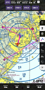
* Now with VFR sectional charts, obstacle avoidance and real-time weather radar *
Primarily meant for GA Pilots flying under 10,000 feet or within cell reception, GA Flight Tracking will allow enthusiasts to track and follow GA aircraft transmitting it's position and altitude. Great for pilots and student pilots flying in busy circuits or uncontrolled aerodromes to see other aircraft in the vicinity.
GA Flight Tracker now has in-app flight planning tools on VFR Charts. Create a flight plan and active the route instantly for navigation guidance.
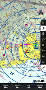
We now deliver offline VFR sectional charts reducing the need for data for navigation.
Offline VFR Sectional Map Coverage:
- 18 European Countries
- All of North America, including Alaska, Hawaii and the Caribbean
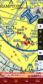
Obstacle Avoidance
Navigate with a piece of mind, knowing GA Flight Tracker will keep an eye out for any obstacles that may be around you within a 5nm radius, at or above your current altitude. Warnings displayed on the screen so you can see their position and be notified of the closest danger.
Obstacle data is updated daily to ensure you have the latest data available for your flight
Precipitation Radar
Overlay worldwide precipitation radar data to avoid areas of heavy rain and thunderstorm activity. The radar data is updated in 10 minute intervals to reduce data usage, and provide you with useful radar imagery.
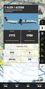
Track & Transmit
Track airborne flights, and transmit your position in real time.
Flight Review & Sharing
Store, review and share unlimited past flights, with on-board audio.
Flight Planner
Plan your flight interactively online and print out professional VFR/IFR navigation logs, weight and balance and fuel endurance calculations.
Real-time Route Mapping
Easily navigate with GPS level flight plan route mapping within the app to assist you and keep you on track during your flight.
With easy to see distance to go for leg, leg ETA, total distance to go and ETA to destination, you can quickly update your ETA's en route based on your current ground speed.
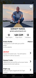
Stored Flight Logs
Keep history of your flight logs automatically with duration of flight, departure and arrival airports, and any custom notes.
More features of GA Flight Tracker:
- Flight Planning tools
- 5 Minute distance meter
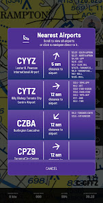
- Offline Airport and Frequency data
- Offline obstacles database (Updated daily)
- Accurate altitude detection using barometer and current area metar data
- Automatic barometric readings from the closest station for absolute altitude readings
- ADS-B aircraft tracking in real-time
- Get route tracks for your flight plan
- Playback of saved flights with audio
- Multi-speed playback of saved flights
- Share saved flights
- Automatic flight logs
- Rank up Gafty levels with logging hours of flight
** Visit our website for your interactive experience and Flight Planning **
https://www.gaflighttracker.com
* Now with VFR sectional charts, obstacle avoidance and real-time weather radar *
Primarily meant for GA Pilots flying under 10,000 feet or within cell reception, GA Flight Tracking will allow enthusiasts to track and follow GA aircraft transmitting it's position and altitude. Great for pilots and student pilots flying in busy circuits or uncontrolled aerodromes to see other aircraft in the vicinity.
GA Flight Tracker now has in-app flight planning tools on VFR Charts. Create a flight plan and active the route instantly for navigation guidance.
We now deliver offline VFR sectional charts reducing the need for data for navigation.
Offline VFR Sectional Map Coverage:
- 18 European Countries
- All of North America, including Alaska, Hawaii and the Caribbean
Obstacle Avoidance
Navigate with a piece of mind, knowing GA Flight Tracker will keep an eye out for any obstacles that may be around you within a 5nm radius, at or above your current altitude. Warnings displayed on the screen so you can see their position and be notified of the closest danger.
Obstacle data is updated daily to ensure you have the latest data available for your flight
Precipitation Radar
Overlay worldwide precipitation radar data to avoid areas of heavy rain and thunderstorm activity. The radar data is updated in 10 minute intervals to reduce data usage, and provide you with useful radar imagery.
Track & Transmit
Track airborne flights, and transmit your position in real time.
Flight Review & Sharing
Store, review and share unlimited past flights, with on-board audio.
Flight Planner
Plan your flight interactively online and print out professional VFR/IFR navigation logs, weight and balance and fuel endurance calculations.
Real-time Route Mapping
Easily navigate with GPS level flight plan route mapping within the app to assist you and keep you on track during your flight.
With easy to see distance to go for leg, leg ETA, total distance to go and ETA to destination, you can quickly update your ETA's en route based on your current ground speed.
Stored Flight Logs
Keep history of your flight logs automatically with duration of flight, departure and arrival airports, and any custom notes.
More features of GA Flight Tracker:
- Flight Planning tools
- 5 Minute distance meter
- Offline Airport and Frequency data
- Offline obstacles database (Updated daily)
- Accurate altitude detection using barometer and current area metar data
- Automatic barometric readings from the closest station for absolute altitude readings
- ADS-B aircraft tracking in real-time
- Get route tracks for your flight plan
- Playback of saved flights with audio
- Multi-speed playback of saved flights
- Share saved flights
- Automatic flight logs
- Rank up Gafty levels with logging hours of flight
Oxirgi yangilanish
Xavfsizlik — dastur ishlab chiquvchilar maʼlumotlaringizni qanday jamlashi va ulashishini tushinishdan boshlanadi. Maʼlumotlar maxfiyligi va xavfsizlik amaliyotlari ilovadan foydalanish, hudud va yoshga qarab farq qilishi mumkin. Bu axborot dastur ishlab chiquvchi tomonidan taqdim etilgan va keyinchalik yangilanishi mumkin.

Tashqi hamkorlarga hech qanday axborot ulashilmagan
Dastur ishlab chiquvchilar axborot ulashilishini qanday aytishi haqida batafsil

Ushbu ilova quyidagi axborot turlarini toʻplashi mumkin
Men haqimda va Suratlar va videolar

Maʼlumotlar uzatish vaqtida shifrlanadi

Maʼlumotlarni oʻchirishni soʻrashingiz mumkin
Reytinglar va sharhlar
3,2
44 ta sharh
Nima yangiliklar
Performance improvements
Fixed VFR Maps
Updated Weather Precip to include Snow
Updated UI design for flight tracking
Ability to Focus on a specific flight and filter out all other flights
Fixed offline Airports and Obstacle data downloads
Added colour coded labels:
Red - within 500 feet of your current altitude
Green - Climbing
Light Blue - Descending
Dark Blue - Cruise

